Download
1 / 13
130 likes | 254 Views
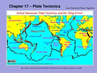
Ch. 17 Plate Tectonics. Are land masses actually moving? Examples: 1. S. America is moving away from Africa at a rate of 2 to 3 cm/yr. 2. Hawaiian islands are moving NW at 8 to 9 cm/yr. How many years would it take these land masses to move a mile?

E N D
Ch. 17 Plate Tectonics Are land masses actually moving? Examples: 1. S. America is moving away from Africa at a rate of 2 to 3 cm/yr. 2. Hawaiian islands are moving NW at 8 to 9 cm/yr. How many years would it take these land masses to move a mile? S. America = 53,333 years or 5,333,300 years/100 miles Hawaiian islands = 17,778 years or 1,777,800 years/100miles In the 1500s a scientist had already noticed that the land masses seemed to fit together like a puzzle, but the understanding of why was not developed yet.
Continental Drift – the concept of the Earth’s continents been joined as a single landmass. • The single land mass (supercontinent) was called Pangaea. • Greek for “all the earth” • This separation occurred approximately 200 MYA • Fig. 17-1 (pg.444) • Wegener was the founder of the theory of Pangaea. He hypothesized that rock types were similar on both sides of the Atlantic. • Observations were made to show that rocks from the Appalachian Mountains were similar to rocks in Greenland and Europe.
Wegener also found fossils that were similar in the U.S., Europe, & Greenland. • Fig. 17-2 (pg. 445) • Evidence of coal deposits in Antarctica also gives evidence of Pangaea. How? • Swampy plant die off to produce coal deposits over time. This means that Antarctica must have been closer to the equator to support plant life. • Most scientist people and scientist didn’t believe Wegener’s theory of continental drift; he couldn’t explain what caused the land masses to move and how could they move without shattering.
Wegener die in 1930. In 1960 scientist discovered evidence on the ocean floor that could explain why and how continents move. • Sonar allowed scientist to study the ocean floor, which allowed scientists to evaluate the peaks and valleys along the ocean floor. • Fig. 17-6 (pg. 449) • The longest continuous mountain ranges are found along the ocean floor. • Volcanoes and earthquakes commonly occur in these areas. • Huge trenches (11 km deep) were also found from the sonar. 6 times greater than the Grand Canyon.
Other technology that supported the evidence was a magnetometer. This device is used to detect small changes in magnetic fields. • This instrument was towed by ships to map the ocean floor. • Rock sediments were also taken from the ocean floor. This proved that rocks near the ocean ridges were younger (volcanoes) than the trenches. Fig. 17-7 • Another discovery showed that the floor sediments on the oceanic floor ( a few 100 m) weren’t as thick as continental deposits (about 20 km).
Magnetism • Before ocean studies were done scientists knew that rocks containing iron-bearing minerals provided a record of the Earth’s magnetic field. • Paleomagnetism is the study of the Earth’s magnetic record. • Basalt is used a lot because of its iron composition. • As basalt cools, the iron-bearing minerals become oriented parallel to the Earth’s magnetic field. • The Earth’s magnetic field can change direction, this is called a magnetic reversal.
In the 1960s scientists found some basalt flows that had showed the Earth’s magnetic field was reversed at one time. • A magnetometers showed that the magnetic field of the ocean floor was much stronger in some areas and very weak in others. Why? • Strong areas match the present magnetic field. • Weak areas show a reversed magnetic field. • Fig. 17-8 • A pattern is evident as the polarity is constant as you work your way out from an ocean ridge. • Can you explain Fig. 17-10 • The polarity matches the basalt flows on Fig. 17-8
Scientists could easily determine the age of the ocean floor due to the magnetic recordings. • The age of the ocean floor is developed as an isochron. Fig. 17-11. • The theory that new ocean crust is formed at ocean ridges and destroyed at deep-sea trenches is called seafloor spreading. • As magma comes up from the ridge it fills and is dispersed out making new crust. This explains the questions of how continents move. • Fig. 17-12 • Continents move with the ocean crust as it moves away from the ocean ridges.
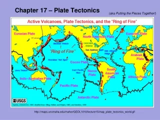
Theory of Plate Tectonics • The theory of plate tectonics refers to the Earth’s crust and rigid upper mantle are broken into huge slabs called plates. • Fig. 17-13 (pg. 455) • Notice that the plates move in several directions and at different rates over the Earth’s surface. • These tectonic plates have plate boundaries were they come together, move away from one another, or move horizontally past one another.
Divergent Boundaries • Plates move away from one another • Fig. 17-14 (pg. 456) • New crust forms. Associated with high heat flow, volcanism, and earthquakes. • The Atlantic Ocean, which has a large divergent boundary, is moving at about 2 to 3 cm/yr.
Convergent Boundaries • The plates are moving towards each other. • 3 Types • 1. oceanic crust converging on oceanic crust. • 2. oceanic crust converging on continental crust. • 3. continental crust colliding with continental crust. • Subduction occurs when one of the 2 plates descends beneath the other plate • Fig. 17-15 (pg. 457) 3 Types • Fig. 17-16 (pg. 458) ocean to ocean
Transform Boundaries • Where plates slide horizontally past each other. • At a transform boundary the crust is only deformed or fractured. • Fig. 17-17 (pg. 459) • At a divergent boundary new crust formed • At a convergent boundary old crust is destroyed by subduction.
Causes of Plate Motions • The question still not totally understood is what cause the plates to move. • It is proposed that large-scale motion in the mantle is the mechanism that drives the movement of tectonic plates. • Convection current in the mantle are the driving force of this. This is caused by the cooler exterior mantle and hotter inner mantle. • Fig. 17-18 (pg. 460) – convection • The unanswered questions include: • 1. How these currents originate? • 2. How big are they? • 3. Are mantle convection currents permanent? • 4. Do they change positions over time? • 5. How do they start and stop? • 6. Does this happen only in the upper mantle?