Download
1 / 8
80 likes | 157 Views
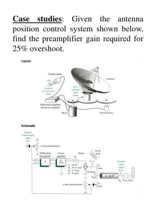
Menemsha Pond System Modeling. By Mitchell Buck. Model . RMA-2 – hydrodynamic numerical model Developed by William Norton and Ian King for the USACE Integrated with Surface-Water Modeling System (SMS) version 10.1

E N D
Menemsha Pond System Modeling By Mitchell Buck
Model • RMA-2 – hydrodynamic numerical model • Developed by William Norton and Ian King for the USACE • Integrated with Surface-Water Modeling System (SMS) version 10.1 • Simulates 2D depth-averaged hydrodynamics using simplified Navier-Stokes Equations
Model Input • Bathymetry • USACE NAE 2013 LIDAR data • USACE NAE 2013 Bathymetric Survey • GEODAS Bathymetric Survey #H11920 • Woods Hole Group 2001 Survey • Boundary Condition – Woods Hole Group 2001 Tide survey • Model Grid – 2001 Model grid with updates
New versus old bathy 2001 2013