Download
1 / 12
120 likes | 288 Views
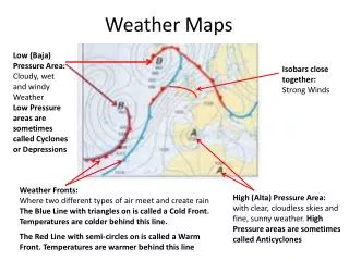
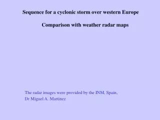
Sequence for a cyclonic storm over western Europe Comparison with weather radar maps. The radar images were provided by the INM, Spain, Dr Miguel A. Martinez.

E N D
Sequence for a cyclonic storm over western Europe Comparison with weather radar maps The radar images were provided by the INM, Spain, Dr Miguel A. Martinez
The data rendering is done to maximize the similarity between day and night color interpretation of clouds, using RGB composite for the following cloud properties: Red: Cloud depth and amount of cloud water and ice. Day: Visible reflectance at 0.6 mm. Night: Optical depth, approximated by 12.0-10.8 mm channels. Green: Cloud particle size and phase. Day: Approximated by 1.6 mm or 3.9 mm solar reflectance component. Night: Approximated by 10.8 –3.9 mm brightness temperature. Blue: Temperature is provided by 10.8 mm day and night. Linked to: using MSG channels
1. Multilayer mature cloud. Low cirrus above Low Cu+Sc. Little or no rain. 2. Thunderstorms. 3. Mature rain cloud, moderate rain. 4. Supercooled Sc+Cu. Little or no precip. 5. Local heavy rain shower. 6. Frontal rain band (red) under broken water layer (yellow) cloud. 7. High level shield (orange) overlying frontal rainband (red), raining on the east side. 8. Mid-level orographic clouds (yellow). No rain. 9. Ciro-cumulus. No rain. 1 1 2 4 3 7 5 4 6 9 8 MSG200310311127_05W40N_149
1 1. Multilayer mature cloud. Low cirrus above Low Cu+Sc. Little or no rain. 2. Thunderstorms. 3. Mature rain cloud, moderate rain. 4. Supercooled Sc+Cu. Little or no precip. 5. Local heavy rain shower. 6. Frontal rain band (red) under broken water layer (yellow) cloud. 7. High level shield (orange) overlying frontal rainband (red), raining on the east side. 8. Mid-level orographic clouds (yellow). No rain. 9. Ciro-cumulus. No rain. 1 2 4 3 7 5 4 6 9 8 MSG200310311142_05W40N_149
1 1. Multilayer mature cloud. Low cirrus above Low Cu+Sc. Little or no rain. 2. Thunderstorms. 3. Mature rain cloud, moderate rain. 4. Supercooled Sc+Cu. Little or no precip. 5. Local heavy rain shower. 6. Frontal rain band (red) under broken water layer (yellow) cloud. 7. High level shield (orange) overlying frontal rainband (red), raining on the east side. 8. Mid-level orographic clouds (yellow). No rain. 9. Ciro-cumulus. No rain. 1 2 3 4 3 7 5 4 6 9 8 MSG200310311157_05W40N_149
1. Multilayer mature cloud. Low cirrus above Low Cu+Sc. Little or no rain. 2. Thunderstorms. 3. Mature rain cloud, moderate rain. 4. Supercooled Sc+Cu. Little or no precip. 5. Local heavy rain shower. 6. Frontal rain band (red) under broken water layer (yellow) cloud. 7. High level shield (orange) overlying frontal rainband (red), raining on the east side. 8. Mid-level orographic clouds (yellow). No rain. 9. Ciro-cumulus. No rain. 1 1 2 3 4 3 7 5 6 4 9 8 MSG200310311212_05W40N_149
1. Multilayer mature cloud. Low cirrus above Low Cu+Sc. Little or no rain. 2. Thunderstorms. 3. Mature rain cloud, moderate rain. 4. Supercooled Sc+Cu. Little or no precip. 5. Local heavy rain shower. 6. Frontal rain band (red) under broken water layer (yellow) cloud. 7. High level shield (orange) overlying frontal rainband (red), raining on the east side. 8. Mid-level orographic clouds (yellow). No rain. 9. Ciro-cumulus. No rain. 1 1 2 3 4 3 7 5 6 4 9 8 MSG200310311227_05W40N_149
2 1. Multilayer mature cloud. Low cirrus above Low Cu+Sc. Little or no rain. Dark red above yellow-white. 2. Thunderstorms. Orange tint on red. 3. Mature rain cloud, moderate rain. Dark red + magenta. 4. Sc+Cu. no-precip. Yellow-white. 5. Local heavy rain shower. Bright Red. 6. Light warm rain showers. Bright Magenta. 7. High level shield, raining on the east side. Orange riding over red. 8. Mid-level orographic clouds. No rain. Intense yellos. 9. Ciro-cumulus. No rain. Dirty yellow. 1 1 3 4 2 7 4 3 Echo Top [km] 2 7 5 4 3 4 6 9 7 8 Reflectivity [dBZ] MSG200310311127_05W40N_149
2 1 1. Multilayer mature cloud. Low cirrus above Low Cu+Sc. Little or no rain. Dark red above yellow-white. 2. Thunderstorms. Orange tint on red. 3. Mature rain cloud, moderate rain. Dark red + magenta. 4. Sc+Cu. no-precip. Yellow-white. 5. Local heavy rain shower. Bright Red. 6. Light warm rain showers. Bright Magenta. 7. High level shield, raining on the east side. Orange riding over red. 8. Mid-level orographic clouds. No rain. Intense yellos. 9. Ciro-cumulus. No rain. Dirty yellow. 1 3 4 2 7 4 3 Echo Top [km] 2 7 5 4 3 4 6 9 7 8 Reflectivity [dBZ] MSG200310311142_05W40N_149
2 1 1. Multilayer mature cloud. Low cirrus above Low Cu+Sc. Little or no rain. Dark red above yellow-white. 2. Thunderstorms. Orange tint on red. 3. Mature rain cloud, moderate rain. Dark red + magenta. 4. Sc+Cu. no-precip. Yellow-white. 5. Local heavy rain shower. Bright Red. 6. Light warm rain showers. Bright Magenta. 7. High level shield, raining on the east side. Orange riding over red. 8. Mid-level orographic clouds. No rain. Intense yellos. 9. Ciro-cumulus. No rain. Dirty yellow. 1 3 4 2 7 4 Echo Top [km] 3 2 7 5 4 3 4 6 9 7 8 Reflectivity [dBZ] MSG200310311157_05W40N_149
2 1. Multilayer mature cloud. Low cirrus above Low Cu+Sc. Little or no rain. Dark red above yellow-white. 2. Thunderstorms. Orange tint on red. 3. Mature rain cloud, moderate rain. Dark red + magenta. 4. Sc+Cu. no-precip. Yellow-white. 5. Local heavy rain shower. Bright Red. 6. Light warm rain showers. Bright Magenta. 7. High level shield, raining on the east side. Orange riding over red. 8. Mid-level orographic clouds. No rain. Intense yellos. 9. Ciro-cumulus. No rain. Dirty yellow. 1 1 3 4 2 7 4 3 Echo Top [km] 2 7 5 4 3 6 4 9 7 8 Reflectivity [dBZ] MSG200310311212_05W40N_149
1. Multilayer mature cloud. Low cirrus above Low Cu+Sc. Little or no rain. Dark red above yellow-white. 2. Thunderstorms. Orange tint on red. 3. Mature rain cloud, moderate rain. Dark red + magenta. 4. Sc+Cu. no-precip. Yellow-white. 5. Local heavy rain shower. Bright Red. 6. Light warm rain showers. Bright Magenta. 7. High level shield, raining on the east side. Orange riding over red. 8. Mid-level orographic clouds. No rain. Intense yellos. 9. Ciro-cumulus. No rain. Dirty yellow. 1 1 3 4 2 7 4 Echo Top [km] 3 7 5 3 4 6 4 9 7 8 Reflectivity [dBZ] MSG200310311227_05W40N_149