Download
1 / 53
530 likes | 816 Views
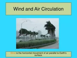
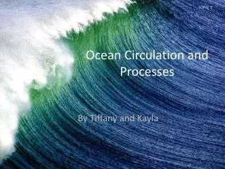
Wind and Ocean Circulation. Density of air is controlled by temperature, pressure and moisture content. Warm air is less dense than cold air and moist air is less dense than dry air.

E N D
Density of air is controlled by temperature, pressure and moisture content. • Warm air is less dense than cold air and moist air is less dense than dry air. • Air pressure is the weight of the air from Earth’s surface to the top of the atmosphere and equals 1.04kg/cm2 (standard air pressure, one atmosphere) at sea level. • Low pressure zone is where air density is lower than in surrounding areas because the air is warmer or has a higher moisture content. • High pressure zone is where air pressure is higher than in surrounding area because of cooling or lower moisture content.
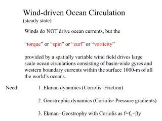
6-1 Atmospheric Processes • Fluids (air and water) flow from areas of high pressure to areas of low pressure. • Change in pressure across a horizontal distance is a pressure gradient. • Greater the difference in pressure and the shorter the distance between them, the steeper the pressure gradient and the stronger the wind. • Movement of air across a pressure gradient parallel to Earth’s surface is called a wind and winds are named for the direction from which they come. In contrast, ocean currents are named for the direction towards which they travel.
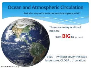
Rotation of the Earth strongly influences winds. • Global winds blow in response to variation in pressure related to uneven solar heating (insolation) of Earth’s surface. • Coriolis deflection is the apparent deflection of objects moving across Earth’s surface to the right of direction of travel in the northern hemisphere and to the left of direction of travel in the southern hemisphere.
Three major convection cells are present in each hemisphere. • The Hadley cell extends from the Equator to about 30o latitude. • The Ferrel Cell extends from 30 o to about 50 o latitude. • The Polar Cell extends from 90 o to about 50o latitude.
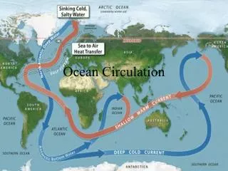
Wind-driven currents are produced by the interaction between the wind and the water. • As wind moves across the water, collision of air molecules with water molecules inefficiently transfers energy from the air to the water. • Water moves at about 3-4% of the wind speed. • Zonal wind flow is wind moving nearly parallel to latitude as a result of Coriolis deflection. • Westerly-driven ocean currents in the trade winds, easterly-driven ocean currents in the Westerlies and deflection of the ocean currents by the continents results in a circular current, called a gyre, which occupies most of the ocean basin in each hemisphere.
Pressure gradients develop in the ocean because the sea surface is warped into broad mounds and depressions with a relief of about one meter. • Mounds are caused by convergences, places where water flows together and sinks. • Depressions are caused by divergences, places from where water rises to the surface and flows outward. • Water flowing down pressure gradients on the ocean’s irregular surface are deflected by Coriolis and the amount of deflection is a function of location and speed.
With time, wind-driven surface water motion extends downward into the water column, but speed decreases and direction changes because of Coriolis deflection. • Eckman Spiral is the spiraling pattern described by changes in water direction and speed with depth. • Eckman transport is the net transport of water by wind-induced motion. • Net transport of the water in an Eckman spiral has a Coriolis deflection of 90o to the direction of the wind. • Along coastal areas Eckman transport can induce downwelling or upwelling by driving water towards or away from the coast, respectively.
Langmuir circulation is a complex horizontal helical (spiral) motion that extends parallel to the wind. • Adjacent helices rotate in opposite directions creating alternating zones of convergence and divergence. • Material floating on the surface becomes concentrated in the zones of convergence and form sea stripes which parallel the wind direction.
Geostrophic flow allows currents to flow long distances with no apparent Coriolis deflection. • Coriolis deflects water into the center of the gyres, forming a low mound. • As height of the mound increases, the pressure gradient steepens pushing the water outward in an attempt to level the mound. • When the pressure gradient equals coriolis deflection, the current flows parallel to the wind around the mound as a geostrophic current and this is called geostrophic flow. • Gyres in the northern hemisphere rotate clockwise and in the southern hemispheres counterclockwise.
The current flow pattern in gyres is asymmetrical with narrow, deep and swift currents along the basin’s western edge and broad, shallow slower currents along the basin’s eastern edge. • The geostrophic mound is deflected to the western part of the ocean basin because of the eastward rotation of the Earth on its axis. • The Sargasso Sea is a large lens of warm water encircled by the North Atlantic gyre and separated from cold waters below and laterally by a strong thermocline. • Western boundary currents, such as the Gulf Stream, form a meandering boundary separating coastal waters from warmer waters in the gyre’s center.
The biology of these rings has been the subject of a concerted research effort. This work examined how the communities of plankton (both phytoplankton and zooplankton) changed as the ring aged. The physical characteristics of the ring also changed -- the water in the core slowly mixed with the surrounding circulating ring, modifying to become warmer or colder depending on the type of ring.
In general, the rings are about 100-300 km in diameter, and they extend to considerable depths. They should be visualized as concentric cylinders, rather than simply surface features. Rings are examples of mesoscale phenomena in the oceans,
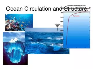
Deep water gradually mixes with other water masses and eventually rises to the surface. • The Atlantic Ocean has the most complex ocean stratification containing the following layers: Antarctic Bottom Water, Antarctic Deep Water, North Atlantic Deep Water, Arctic Intermediate Water, and Mediterranean Intermediate Water • The Pacific Ocean has a less complex stratification, is weakly layered, displays sluggish circulation and is remarkably uniform below 2000m. • The Indian Ocean has the simplest stratification consisting of Common Water, Antarctic Intermediate Water, and Red Sea Intermediate Water.
Thermohaline circulation is a density driven flow of water generated by differences in salinity or temperature. • Water at the surface is exposed to more rapid changes in salinity through evaporation or precipitation and in temperature through cooling or heating. • Once water is isolated from the atmospheric influences, salinity and temperature are largely set for an extended period of time. • Based upon depth, surface water masses can be broadly classified as Central waters (from 0 to 1 km), Intermediate waters (from 1 to 2 km), and Deep and bottom waters (greater than 2 km).
Most deep and bottom water originated at the surface where cooling and increased salinity raised their density until they sank. • Ocean basins interconnect and exchange water with each other and with the surface. Inter-ocean basin circulation and exchange between surface and deep water appears largely driven by waters of the North Atlantic.
The major thermohaline currents appear to flow mainly equatorward, but this is because they originate in the polar regions and their outward flow is confined between the continents. • Warmer water (>10oC) is confined between 45o north and south latitude. • Poleward of 45o, density of water increases because of declining temperature and increased salinity because of evaporation or ice formation. • The water sinks to a density-appropriate level and then slowly flows outward in all directions across the basin until they are blocked by a continent.
Most seas are indentations into continents, partially isolated from the ocean and strongly influenced by continental climate and river drainage. • As Atlantic Ocean water flows through the Straits of Gibraltar into the Mediterranean Sea at the surface, warm, highly saline Mediterranean Sea water flows out through the Straits at the bottom. • In the Black Sea the surface water is brackish because of excess precipitation and river inflow.