Download
1 / 43
440 likes | 664 Views
Vegetation monitoring of the wetland reconstruction area in Hanság (Hungary). Katalin Margóczi ( University of Szeged, Department of Ecology ) Gábor Takács ( Fertő-Hanság National Park Directorat e) László Körmöczi ( University of Szeged, Department of Ecology ). The hiStory of Hanság.

E N D
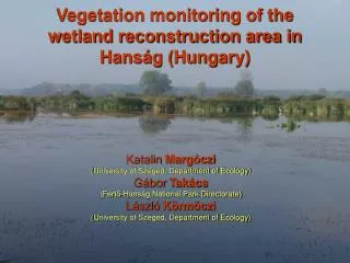
Vegetation monitoring of the wetland reconstruction area in Hanság (Hungary) Katalin Margóczi (University of Szeged, Department of Ecology) Gábor Takács (Fertő-Hanság National Park Directorate) László Körmöczi (University of Szeged, Department of Ecology)
The hiStory of Hanság Wien Bratislava Lake Fertő (Neusiedler see) Till the 19th century Hanság was a 50 000 ha large wetland, connected with the Lake Fertő. Today only the Fertő is indicated as wetland on the map. Hanság
There are tree plantations, meadows, ploughlands on the former fen area (outlined by red line)The blue line shows the outline of wetland reconstruction.
The area of wetland reconstruction (red line) on the military map from 1783-84. The ancient Hanság was a large, mostly floating fen, with small lakes, sedges, reeds and some alder forest patches.
In 1883-1884 the main drainage channels can be seen on the map, and mainly wet meadows instead of floating fen The drastic drying-out of the fen was „successful” only in the early 20th century, using machines to dig channels. Secondary meadows formed in the place of the fen, and most of the lakes disappeared. A large part of the area was ploughed, afforested, and peat mines were opened.
Nature protection In spite of drainage and a lot ofhuman disturbance, the Hanság could save a relatively large part of its natural values. Patches of natural vegetation survived in the wet meadows and forests, and the aquatic communities partly survived in drainage channels. Hanság became a protected natural area in 1976, and since 1994 it has been a part of the Fertő-Hanság National Park. Hottonia palustris in a channel
The most serious deficiency of the protected area is the very few remaining wetland, so the National Park Directorate decided to restore wetland areas. Restoration of a larger area of the former fenby closing the channels would be nice, but present human activities, demands and the changes of hydrology make it impossible. Technical possibilities, safety, ownership and economical criteria were considered in priority when choosing the 400 ha area to be flooded. The restoration was supported by Hungarian and Dutch Governments
The main goals of restoration: • To create wetland with open water, suitable habitat for water-birds and fen-plants. • To have a model area, and to get experiencies of rewetting. • To decrease invasive plant species (Solidago gigantea).
A habitat map were made before flooding. Large sedges (57%) (Carex riparia, C. acutiformis), and wet meadows (28%) (Alopecurus pratensis, Festuca arundinacea) were the dominant vegetation types and some reeds(5%) (Phragmites australis, Glyceria maxima) alsooccured.
Technical aspects of reconstruction Dikes were built around the planned wetland pools, and water was transported by gravitation through sluices from the river Rábca and the channel Kismetszés. The 1st and 2nd unit was flooded in spring 2001, and the 3rd unit in autumn.
The water-level is intended to keep constant. The water depth is between 0-100 cm. The year 2001 and 2003 was very dry, so the water level was about 20 cm lower.
2001.06.15. 2001.04.27. 2001.09.19. Aerial photos from the first year of flooding.
The landscape of the reconstructed area is really beautiful, it is one of the main „attractions” of the National Park.
Autumn wiev of sedges Open water area Tussoks of sedges Persicaria amphibia field
Monitoring methods • Small scale monitoring: 5x5 m phytosociological relevés along 21+4 permanent transects every year. • Large scale monitoring: vegetation mapping using aerial ortophotos in every 3rd year, and developing GIS database.
Small scale monitoring method: permanent transects The percent cover of plant specieswererecorded in 20 pieces of 5x5 m quadrates along each transect. The end of the transects were marked by wooden sticks, and positioned using GPS. 5 m 100 m
Results of small scale monitoring Each of the 420 relevés were categorized into vegetation types, named according to the dominant species. The vegetation is slightly different in the three units of restoration area.
The main vegetation categories Water-plants Glyceria (maxima) Phragmites (australis) Typha (latifolia, angustifolia) Sedges (Carex acutiformis, C. riparia)
The depth of the water is one of the main environmental factor affecting vegetation development Finer categories, differentiated by cluster analysis
Changes of vegetation in the first 3 years after flooding • Dryland vegetation disappears (2nd year) • Typha increases • Open water and water-plants increase • Sedges decrease (3rd year)
The permanent transect method is suitable for fine detection of local vegetation changes Percent cover of species Species Sample Sequence of individual relevés
Transect 1.2 Glyceria overgrows in the deep water, Carex survives at 50 cm water depth. 2001 2002 2003 Water depth (cm)
Transect 1.5Glyceria overgrows Phalaroides, but disappears in the 3rd year in 80 cm deep water 2001 2002 2003 Water depth (cm)
Transect 2.4 Carex disapperars in the 3rd year from 80 cm deep water, Persicaria grow up in the open place. 2001 2002 2003 Water depth (cm)
Transect 2.3 Typha latifolia outcompetes Carex riparia in the 3rd year at 40-50 cm water depth. 2001 2002 2003 Water depth (cm)
Large scale monitoring Parameters of the aerial photograph: • Service: Telecopter Kft. • Date of flight: 2003.07.15. (12:00 – 12:15) • Film material: K color III 2444 • Flying height: 1200m • Camera: Wild RC-10 (f=153,1mm) • Overlap: 60% • Resolution: 1 m
Processing of the aerial photoghraph • Scanning with 18μm resolution and 16 bit color depth. Ortorectification with field reference points by ERMAPPER 6.1 and DIGITERRA (Hungary) softwares. • Outline the possible patch contours in the computer.
Developing GIS data base (ESRI ArcView 3.2) • Identification and correction in the field. (vegetation category, main species and their cover, total vegetation cover) • Data processing by raster analysis (One pixel is 1x1 m) • GRID statistics
Results of large scale monitoring • Detailed description of vegetation categories. • Thematic maps about the restored area. • Statistics.
Detailed description of vegetation categories Sample 62 vegetation types were distinguished and described
Thematic maps about the restored area. Total plant cover above the water level
Raster statistics Area (in ha) of vegetation categories in the whole restored area in 2003.
Do the permanent transects represent appropriately the whole restored area ? Glyceria is overrepresented Water plants are underrepresented
Evaluation of restoration • Natural wetland communities are developing in the area. • The landscape is beautiful. • It is a very important breeding and feeding area of birds. (Zoological monitoring is being made as well!) • The hydrology is considerably different from the original situation. • Natural communities are not the same, than before drainage of the ancient fen.
Future • The National Park is ready to follow wetland restoration! • Forestry and agriculture cause severe soil degradation in this area, so wetland restoration would become soon the only logic land use in Hanság! • The change of the water management in the whole area of Hanság is necessary for saving the natural values.
Gábor TAKÁCS Katalin MARGÓCZI László KÖRMÖCZI Thank you for your attention!