Download
1 / 34
410 likes | 665 Views
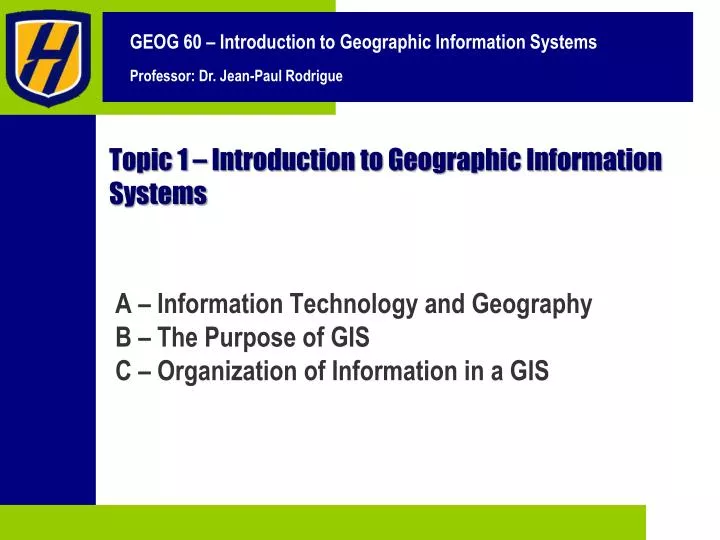
Topic 1 – Introduction to Geographic Information Systems. A – Information Technology and Geography B – The Purpose of GIS C – Organization of Information in a GIS. The Objectives of this Topic. Understand GIS as an information technology.

E N D
Topic 1 – Introduction to Geographic Information Systems A – Information Technology and Geography B – The Purpose of GIS C – Organization of Information in a GIS
The Objectives of this Topic • Understand GIS as an information technology. • Understand the basic methods of information analysis in a GIS.
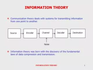
Information Technology and Geography A • 1. What is Information? • 2. What is Geographical Information? • 3. What are Geographic Information Systems?
1 What is Information? • Information • Knowledge about something. • Recorded in some way. • Information age • The computer has become the main mean of storing and accessing information. • Tremendous amounts of digital information created: • Spreadsheets. • Databases. • Internet. • Most of the “interesting” jobs involve information processing. Database A Part No. Qty Description 103521 5 Wheel spoke 105322 1 Ball bearing 106832 6 Wheel rim 104338 2 Tire 103922 7 Handlebars Database B Date Address Type 1/22 123 James St. Robbery 1/26 22 Smith St. Noise 2/24 9 Elm Dr. #4A Assault 3/02 12 Fifth Ave. Vandalism 3/10 1067 Park Robbery
1 What is Information? Database B Date Address Type 1/22 123 James St. Robbery 1/26 22 Smith St. Noise 2/24 9 Elm Dr. #4A Assault 3/02 12 Fifth Ave. Vandalism 3/10 1067 Park Robbery Geocoding Elm Smith 5th Park James
1 What is Information? • Information Systems • Dominant tool. • Set of computer programs that are used to input (encode) information and store it in a structured manner. • Can be retrieved, analyzed and, finally, reported as a table, graph, map or picture. Information System Encoding Low order task Repetitive Automatic Established Structure Management Analysis High order task Unique Reporting Medium order task Common
1 What is Information? • “Knowledge is power” • Having information offers a way to control the parameters of our environment. • Making decisions (resource allocation). • With perfect information, one should be able to make optimal decisions. • Impossible to be perfectly informed, so decisions are always imperfect (sub-optimal). No Information “Pure Luck” Available Information Imperfect Information Sub-optimal Decisions Optimal Decisions Perfect Information
2 What is Geographical Information? • Spatial information • Between 70 and 80% of the digital information is spatially related. • Can be placed on a map. • Tools to deal with this information are consequently very useful. • Reveal information that was previously “hidden”. Destination Customer addresses Store / factory / warehouse location Census information Environmental information Resource location
1 A Taxonomy of Information • Land Use • Name of places GIS • Population • Temperature • Distance • Density Spatial Information Qualitative Quantitative • Name of people and organizations • Qualitatives • Stock market quotes • Quantitatives Aspatial
2 What is Geographical Information? • Spatially related • Can be assigned coordinates or any spatial reference. • On the surface of the earth. • Involves location and organization. • Scale • Can be from general to specific. • Simple to complex. • A satellite can generate one terabyte (1012 bytes) of information per day. • Dynamics • Spatial dynamics (variations in space). • Temporal dynamics (variations in time). Coordinate system Scale Time 2 Time 1
B The Purpose of GIS • 1. What is a GIS? • 2. History of GIS • 3. General Purpose
1 What is a GIS? • Geographic Information System • Form of Information System applied to geographical data. • Produce information which will be useful in decision-making. • Managing use of land, resources, transportation, retailing, oceans or any spatially distributed entities. • Connection between the elements of the system is geography, e.g. location, proximity, spatial distribution. • System of hardware, software and procedures • Support the capture, management, manipulation, analysis, modeling and display of spatially-referenced data. • Solving complex planning and management problems.
1 What is a GIS? • Information Systems • Information system specializing in the input, storage, manipulation, analysis and reporting of geographical (spatially related) information. Geographic Information System Digitizing maps Encoding spatial data (census, vegetation, topography, etc…) Encoding Geographic database in a spatial data format Management Analysis Spatial analysis Reporting Thematic maps
1 Basic Structure of a GIS Data Input Query Geographic Database Transformation and Analysis Output: Display
1 What is a GIS? Information System Geographic Records Fields
2 History of GIS • Prior to 1960 • GIS’s origins lie in thematic cartography. • Many planners used the method of map overlay using manual techniques. • The 1960s and 1970s • Many new forms of geographic data and mapping software. • First GIS developed in Canada for land use inventory. • Development of the first computer cartography packages for mainframe computers. • First remote sensing images. • Mathematical Models.
2 History of GIS • The 1980s and 1990s • First commercial GIS Packages. • Diffusion of Microcomputers. • Integration with other software (mainly CAD and databases). • US Census Bureau efforts in the 1980s: • Digitize spatial, economic and demographic attributes of the United States. • Creation of the TIGER format (Topologically Integrated Geographic Encoding and Reference ). • The 2000s • Integrated Information technologies with geography. • Powerful applications on desktop computers. • Web/network based data sources. • Portable and inexpensive field GISs with GPS capabilities.
3 General Purpose • GIS is a database application • All information in a GIS is linked to a spatial reference. • Other databases may contain locational information (street addresses, zip codes, etc.). • GIS database uses geo-references as the primary means of storing and accessing information.
3 General Purpose • GIS is a tool • Must serve a purpose. • Not an end in itself but a mean (process) to achieve this end. • Should be viewed as a process rather than as software or hardware. • For decision-thinking (scenarios) and decision-making (strategies). • 75% of the time used to be spent at building the spatial database: • Acquiring data for a new GIS has become much simpler.
3 General Purpose • Advantage • Ability to integrate vast quantities of spatial information. • Provide a powerful repertoire of analytical tools to explore this data. • Ability to separate information in layers: • Combine it with other layers of information. • Good employment opportunities (information society). • Disadvantage • Long process of encoding and verifying the integrity of information. • Compatibility between different GIS (less an issue). • Technology changes rapidly. • Information overload.
3 General Purpose • GIS as an Integrating Technology • Evolved by linking a number of discrete technologies: • A whole that is greater than the sum of its parts. • Integrate geographical data and methods: • Support traditional forms of geographical analysis. • Map overlay analysis. • Thematic mapping. • New types of analysis and modeling: • Beyond the capability of manual methods. • Possible to map, model, query, and analyze large quantities of data all held together within a single database. • Integrates people, data, hardware and software.
3 General Purpose • People • Map user: end consumer. • Cartographer: producer of the end product of a GIS. • Analyst: applies methods to solve geographical problems. • Database administrator: build, update and administer databases. • Data • Remote sensing images or aerial photographs. • Topographic maps. • Land records. Etc. People GIS Software Data Hardware
3 General Purpose • The GIS Job Market • About 500,000 GIS users in the United States (another 500,000 for the rest of the world). • 10% (50,000) are using GIS full-time. • 15% growth each year. • 75,000 people a year receive GIS training. • Shortfall in training and advanced degrees. • High demands to integrate GIS in all levels of the educational system.
C Organization of Information in a GIS • 1. Layers • 2. Features • 3. Attributes • 4. Relationships
1 Representation of Geographical Information in a GIS Thematic Map of the Continental United States
States Rivers Lakes Roads Capitals 1 Maps are Composed of Layers
2 Features • Layers contain features or surfaces • Features • Real world objects. • Natural or man-made. • Represented on a map as a single entity. • Each map feature has a location, shape, and symbol that represents one or more of its characteristics. • Surfaces • Some elements do not have a distinct shape. • E.g. : elevation, slope, temperature, rainfall. • Raster is the most common surface; composed of a grid.
2 Features • Points • Points represent objects that have discrete locations and are too small to be depicted as areas. • Schools, traffic lights, crime locations, and park benches are examples of point features. • Lines • Lines represent objects that have length but are too narrow to be depicted as areas. • Freeways, streets, pipelines, and waterways are examples of line features. • Polygons • Polygons represent objects too large to be depicted as points or lines. • Parks, census tracts, postal codes, and trade areas are examples of polygon (or area) features.
2 Features in ArcMap (Data View)
3 Attributes • Attributes • Features are stored in a database along with information describing them. • The descriptive information stored with a feature. • Attributes of a street might include its name, street type, length, street code, number of lanes, and pavement type. • The attributes of a park may be its name, area, hours of operation, and maintenance schedule. Street name, Width, Direction, Lanes Address, Lot #, Type, # Rooms, Owner, Value
3 Attributes • Relationships • Features and their attributes are linked. • Types: • One feature as one record in a database. • Many features to one record. • Access the attributes for any feature or locate any feature from its attributes. • Attributes are displayed in a spreadsheet-like ArcView document called a Table. Features Attributes
3 Attributes
4 Layout • Layout • A GIS links sets of features and their attributes and manages them together in units called layout. • Consists of a collection of geographic features. • Attributes for those features. • Thematic map • A map (set of features) which visually represents a set of data (attributes) is called a thematic map.
4 Layout View in ArcMap