Severe Weather Operations
Severe Weather Operations. Severe Weather Staffing (Positions in orange are minimum needed). Severe Weather Coordinator – oversees the operations of the office during severe weather. Sometimes combined with the Public Forecaster
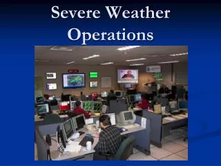

Severe Weather Operations
E N D
Presentation Transcript
Severe Weather Staffing(Positions in orange are minimum needed) • Severe Weather Coordinator – oversees the operations of the office during severe weather. Sometimes combined with the Public Forecaster • Public Forecaster – issues the public forecasts, and long term watches / advisories / warnings • Aviation forecaster • Public service – handles routine public service duties including upper air balloons, phone calls (media included), climate products, and NWR • Warning meteorologist(s) – issues convective warnings
Severe Weather StaffingOptional extra positions that may be staffed Short term forecaster – writes the Short Term Forecasts Communications coordinator – handles phone calls, notification of warnings via phone / NAWAS / radios, gathers and issues storm reports, handles media requests More recently - someone to manage our NWS Shreveport web homepage, including graphical depictions of the weather and headlines displayed on our homepage
Severe Weather Staffing • Clear assignment of job tasks during severe weather will (all have occurred at this office): • Avoid two warnings being issued for the same county or parish at the same time by different people. • Avoid two short term forecasts being issued at the same time by different people. • Avoid NO short term forecast being issued at all because it was not clear who was suppose to issue them. • Avoidance of “What we have here is, failure to communicate” between NWS staff members. • Provide clear communication between the NWS and our outside users, including the media, Emergency Managers, and first responders!
Tornado Warning Criteria In the late 1990s, Lee Harrison and I conducted a study to derive a list of factors that comprise a tornadicmesocyclone. It concentrated on about 50 tornadic and non-tornadicmesocyclones in the four state area. Since then, additional mesocyclone cases have been examined (about 80) to fine tune our suggested tornado warning criteria.
Tornado Warning Criteria • The results of one of the earlier studies were presented at the 1998 AMS Severe Storms Conference by Bill Parker and myself. • This study produced a nomogram of rotational mesocyclone shear values (calculated using AWIPS VR-Shear tool) associated with tornadoes in the four state area.
Tornado Warning Criteria • We also incorporated rotational velocity from a modified version of a previously developed nomogram.
Tornado Warning Criteria • We came up with the current Tornado Warning criteria (on the next slide). • These criteria are used as guidelines for Tornado Warnings. They are not strict criteria that have to be precisely met for a Tornado Warning to be issued. The staff have flexibility of when they feel a Tornado Warning is needed.
Tornado Warning Criteria • A cyclonic rotational couplet in the lower levels of the storm (approx. 1000 - 10,000 ft AGL). A gate to gate signature of maximum inbound and outbound wind is particularly dangerous, but not required. • A SRM velocity in either the inbound or outbound wind of the mesocyclone couplet of >40 kt at any distance from the radar. • A VR shearrotational velocity of >30 kt at any distance from the radar. • A VR shear rotational shear of .008 withing 60 miles, or .006 beyond 60 miles.
Microburst Warning Criteria • A local study was conducted on microburst warning criteria and published a SR Technical Attachment in 1997. • The study developed a conceptual model of a microburst, and radar “proof” of this model.
Microburst Warning Criteria • High reflectivity core of 50 dBz to heights of 25,000 ft AGL. • Storm core velocity convergence of >50 kt somewhere in the layer 5000 - 11,000 AGL in or near the high reflectivity core. • Severe thunderstorm warnings based on these guidelines should contain wording about strong damaging winds.
Severe Weather Briefing NWS provides weekly weather briefings on Thursday mornings to media and emergency managers. Prior to severe weather or winter weather event, NWS may provide a special briefing.
Severe Weather Operations Questions / Comments
Dual Polarization RadarMedia Training Dual Polarization is expected to be installed in the NWS Doppler Radar in January, 2013. Training for our media partners is provided by the Warning Decision Training Branch (WDTB) in Norman, OK. Training consists of going through 13 modules on a web site provided to you. The 13 modules cover the 6 new products that Dual Polarization Radar provides.
Dual Polarization RadarMedia Training The training should be completed about 1 month prior to the installation of Dual Polarization at NWS Shreveport Doppler Radar. The web site for the training modules is: http://www.wdtb.noaa.gov/courses/dualpol/ outreach/
Dual Polarization RadarMedia Training The six new products the Dual Polarization Radar provides are: Correlation Coefficient (CC) Differential Reflectivity (ZDR) Specific Differential Phase (KDP) Hydrometeor Classification (HC) Melting Layer (ML) Quantitative Precipitation Estimation (QPE)