Download
1 / 27
270 likes | 444 Views
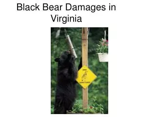
Black Bear Damages in Virginia. Executive Summary. Analyze incidents of damage performed by black bears based upon county of incidence and type of occurrence. POTENTIAL SOLUTIONS: providing more resources for counties that are shown to have an increased likelihood for bear damage and conflict

E N D
Executive Summary • Analyze incidents of damage performed by black bears based upon county of incidence and type of occurrence. • POTENTIAL SOLUTIONS: • providing more resources for counties that are shown to have an increased likelihood for bear damage and conflict • changes in land use and zoning for those counties with a higher incident rate.
Goals • Determine which Virginia counties have the most incidents of black bear damage and sightings, as well as the various types • Obtain an accurate portrayal of black bear confrontations within Virginia
Objectives • Create map of Virginia counties • Convert data from raw data into .dbf table • Join data to county shapefile and analyze
Data • County shapefile • VDGIF raw data for 2006-2007 • PROBLEMS • scattered reporting • 2 different codes used on forms
Analysis • Simple chloropleth maps • Import data as .dbf table • Join damage info with VDGIF county table • Join combined tables to county shapefile
Analysis 2 • Create new layers for various types of incidents • Select by attribute for each element and export selected features • Convert each new layer into individual chloropleth map based on number of incidents
Conclusions – Recommended Solution • Stringent monitoring and increased resources for counties with significant damage incidents • Include educational materials and trained personnel
Conclusions - Counties • SIGNIFICANT ACTIVITY • Albemarle – 233 incidents • Tazewell – 61 incidents • Campbell – 42 incidents • LOWER ACTIVITY • Clarke, Page, Madison, Lancaster, Bath, Giles, Pulaski, Wythe, Carroll, Grayson, Buchanan, Wise, and Lee
Conclusion - Problems • Problems importing tables • Geodatabase would not work • Editing tools would not work • Data problems - confusing
Conclusion - Changes • More detailed map – topology • Include surrounding cities
Future Suggestions • Compare county population vs. number of incidents • Potential population growth • Types of land use – i.e. farming vs. urban • Pinpoint more precise location within counties for each incident • Use more years in data
References • Jamie Sajecki – Black Bear Project Leader, Wildlife Division, Virginia Department of Game and Inland Fisheries • Dr. Michael Vaughan, professor of Wildlife Sciences, Virginia Tech, • GISTutorial