Download
1 / 15
150 likes | 341 Views
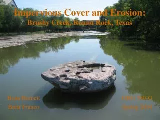
Impervious Cover and Erosion: Brushy Creek, Round Rock, Texas. GRG 360-G Spring 2004. Beau Barnett Brett Franco. Erosion and Soil Loss Due to the Increase in Impervious Cover. Increase in impervious cover can have detrimental effects on soil loss and stream erosion .

E N D
Impervious Cover and Erosion:Brushy Creek, Round Rock, Texas GRG 360-G Spring 2004 Beau Barnett Brett Franco
Erosion and Soil Loss Due to the Increase in Impervious Cover • Increase in impervious cover can have detrimental effects on soil loss and stream erosion. • Soil Infiltration rate goes down with more impervious cover. • Runoff increases when there is less soil infiltration. • With more runoff, the chance for greater soil loss increases
Area of Study Williamson County Round Rock, Texas Brushy Creek
Population Boom of Round Rock • From 1990 to 2000, population of Round Rock has more than doubled. • 1994 Dell Computers moved it’s headquarters from Austin to Round Rock, creating over 10,000 jobs for the area. • With an increase in population, rapid urbanization occurred.
Methods Used for Analysis • Delineation of Brushy Creek and morphometric analysis using ArcHydro • Model soil erosion and soil loss using the Revised Universal Soil Loss Equation (RUSLE) • Digitizing zones of impervious cover and area analysis using the Field Calculator
Sources Secondary Data: • 30 meter DEMs from TNRIS • 2.5 meter DOQQs for Round Rock, Texas • Annual Rainfall Data for Round Rock, Texas
Techniques • Revised Universal Soil Loss Equation (RUSLE) • A = R * K * LS * C * P • A = estimated average soil loss in tons per acre per yearR = rainfall-runoff erosivity factor K = soil erodibility factorL = slope length factorS = slope steepness factorC = cover-management factorP = support practice factor
RUSLE Factors • R = 94 • Estimated value from tamu.edu • K = 0.5 • Estimated value due to rocky sandy soils • LS = Grid derived from slope and flow accumulation • C = 0.75 for West Brushy Creek, 0.35 for East Brushy Creek • Value based on percentage of impervious cover in basin • P = 1 • Value constant due to size of study area
Sources of Error • More recent DOQQs • Imprecise soil data for K factor • C factor is not constant on a landscape • RUSLE equation is a model, not an exact science!
Future Research • Better defined factors for RUSLE equation • More widely available data • Study amount of soil deposition downstream • Development of environmentally sensitive construction practices • Use of newly developed pervious concrete
Conclusions • With the relocation of Dell causing a population boom in Round Rock the amount of impervious cover increased greatly. • This in turn increased runoff and soil erosion in the area and measures need to be taken to lessen the impacts of this urban sprawl.
Works Cited • http://www.tnris.state.tx.us • http://www.iwr.msu.edu/rusle/ • http://www.dell.com/ • http://www.ci.round-rock.tx.us • http://www.utexas.edu/depts/grg/hudson/grg360g/EGIS/E_grg360g.htm