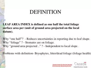
DEFINITION
DEFINITION. LEAF AREA INDEX is defined as one half the total foliage surface area per (unit of ground area projected on the local datum). Why “one half”? - Reduces uncertainties in reporting due to leaf shape. Why “foliage” ? - Stomates are on foliage.

DEFINITION
E N D
Presentation Transcript
DEFINITION LEAF AREA INDEX is defined as one half the total foliage surface area per (unit of ground area projected on the local datum). Why “one half”? - Reduces uncertainties in reporting due to leaf shape. Why “foliage” ? - Stomates are on foliage. Why “ground area projected ..” ? - Independent to local slope. Problems with definition- Bryophytes, litter/dead foliage (foliage health).
Surface Measurement Methods • Cut all leaves and measure (volume displacement + scaling by mass). • Inclined point quadrats. • Direct gap fraction. • Diffuse hemispherical. • Invert a stand ray tracing model (to complex) • Allometric methods (may not be locally representative)
Inclined Point Quadrats Gives LAI directly if we know G function!! Costly and difficult for high canopies but ... b f
Direct Gap Fraction TRAC ALSO ESTIMATES W STILL NEED G!
Diffuse Hemispherical Unlike point quadrat we must integrate over non-negligible azimuth! STILL NEED W!
Hemispherical Lens Issues Sensitivity to Zenith Sampling Sensitivity to Thresholding (exposure)
What Affects Le Estimates More: G(q) with Hemispherical or W(q) with Gap Fraction?
CCRS Re-Calibration of LAI-2000 Effective LAI (average of 7-10 samples/site)
BOREAS NSA-OBS 2m CASI Reflectance Image Red (as red), NIR (as green), Blue (as blue)
BOREAS SSA-OJP 2m CASI Reflectance Image Red (as red), NIR (as green), Blue (as blue)
CASI 2m vs. “BIGFOOT” Krigged Le: NOBS LAI-2000 Footprint (r=35m)
CASI 2m vs. “BIGFOOT” Krigged Le: SOJP LAI-2000 Footprint (r=45m)
Summary: CASI 2m vs. “BIGFOOT” Le and Arithmetic Mean Error bars = mean absolute difference between actual and kriging at 2m resolution.
0 LAI 5 TM 30m, June 6, 1996 CASI 2m, Feb 06,1996 BOREAS NSA-OBS b. a. Reflectance Color Composites d. c. Estimated LAI Figure 1
4 4 4 4 3 3 3 3 2 2 2 2 30m RSR L + Open Area 30m RSR L 1 1 1 1 0 0 0 0 0 1 2 3 4 0 1 2 3 4 CASI L CASI L 1km RSR L + Open Area 1km RSR L 0 1 2 3 4 0 1 2 3 4 CASI L CASI L Figure 7 Density Plots of CASI FLIM-CLUS vs. Aggregated TM Reduced Simple Ratio (RSR) LAI over BOREAS NOBS
“1km” AVHRR/VGT vs. Aggregated TM LAI: Worst Case Water correction - removal of sub-pixel water body effect assuming SR=1 for water.
Correction of Scaling Errors with Sub-Grid Land Cover Open area correction - removal of sub-pixel water body effect assuming constant open area SR.
Conclusions • Surface LAI needs multiple angle and transect measurements • 1km LAI/pixel is a fn of subpixel LAI distribution • Subpixel LAI governed by Land Cover as the critical factor • Land cover spatial scale varies with biome/landscape characteristics • Spatially fixed sampling design may not generally optimal • Better estimate of ‘true’ LAI for validation: • measure LAI of Land Cover types (a range for each), • multiply these by fractions of LC present/pixel • need hi-res LC data) • Similar approach can be used for calibration of models.
What’s Next for CCRS • Multitemporal Validation • Site revisits • Burn chronosequence • Forest health. • More spatial sampling • Grasslands, Tundra, Mountains • New field and airborne instruments. • LIDAR, IKONOS, TRAC II, Digital Cameras • Closer ties to reflectance calibration.