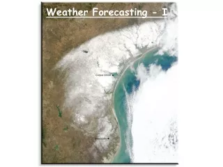
Weather Forecasting
Weather Forecasting. Know the role of weather forecasting and its implication to the field of aviation. 1. Name the major weather services used to provide weather forecasts. 2. Describe the instruments used for predicting weather.


Weather Forecasting
E N D
Presentation Transcript
Weather Forecasting Know the role of weather forecasting and its implication to the field of aviation. 1. Name the major weather services used to provide weather forecasts. 2. Describe the instruments used for predicting weather. 3. State the role of weather satellites in predicting weather. 4. Describe the communications methods used to provide weather information.
Overview 1. Weather People and Service. 2. Weather Data Collection. 3. Communicating Weather Data. 4. Forecasting as a Service.
Weather People and Service • The National Weather Service (NWS) • Part of National Oceanic and Atmospheric Administration (NOAA) • Reports the weather of the United States and possessions • Issues warnings • Supports aviation, marine, agriculture, forestry • Maintains nations basic WX network • Operates two storm-warning services
Weather People and Servicehttp://www.afweather.af.mil/shared/media/document/AFD-080827-088.wmv/ • The Air Force Weather Agency • Works in conjunction with the NWS. • The armed services have their own weather services. • Serves as DoD’s primary weather production facility. • 1000 agency members at 20 locations. • Executes a worldwide weather support mission.
Near-Surface Measuring Instruments • Barometer • Invented in 1643 to measure atmospheric pressure. • Force is transmitted in all directions through any fluid, easily measured by observing the height in a column of liquid.
Near-Surface Measuring Instruments • Thermometer • Used to measure temperature. • Most common type is the mercury thermometer. • If temperature increases, the mercury expands.
Near-Surface Measuring Instruments • Hygrometer • Instrument to measure the amount of moisture in the air. • Uses the change in length of an organic object. • The fiber tends to lengthen in damp air.
Near-Surface Measuring Instruments • Psychrometer • Used to measure relative humidity. • Two similar thermometers are mounted side by side. • Dry bulb • Wet bulb
Worldwide Sensing and Surveillance • Pilot Balloons • Pilot balloon observations (PIBALS) help determine cloud height. • Elapsed time is multiplied by standard rate to compute height. • Radiosonde • Instrument for measurement and transmission of pressure, temperature and relative humidity. • Carried into the atmosphere by balloons or rocket mounted. • Ceiling of 100,000 feet.
Worldwide Sensing and Surveillance • Dropsonde • A radiosonde that is dropped by parachute from aircraft. • Primarily used over water or areas where ground stations aren’t maintained. • Rawinsonde • Upper air observation that evaluates wind, temperature, relative humidity, and pressure aloft. • Carries a corner reflector so it can be tracked by radar.
Worldwide Sensing and Surveillance • Storm Detection Radar and Weather Aircraft • Gathers data showing rain, hail, thunderstorms, tornadoes and hurricanes. • Doppler radar detects the intensity and direction of storms.
Worldwide Sensing and Surveillance • Storm Detection Radar and Weather Aircraft • Aircraft reconnaissance results in observations and reports of critical weather data from oceanic areas. http://www.youtube.com/watch?v=KWVMcLQioQs
Worldwide Sensing and Surveillance • Solar Observation Network • Monitors the events occurring on the Sun. • Monitors solar radiation through space and the radiations effects on the Earth.
Weather Satellites • Enable weathermen to view nearly entire planet. • Carry advanced photographic and measurement equipment.
Weather Satellites • Program began in 1960 with initial launch of TIROS series. • Television InfraRed Observation Satellite (TIROS). • NIMBUS succeeded TIROS allowing 24 hr surveys. • Using these satellites cloud cover over a larger part of the Earth could be photographed 24 hours a day. • All NIMBUS satellites were launched into polar or near-polar orbit.
Weather Satellites • TIROS-N and NOAAs • Launched in 1978 in a sunsyncronous orbit. • A sunsyncronous orbit places the satellite in polar orbit at the proper time and orbital altitude to keep the craft constantly in sunlight. • TIROS-N transmits cloud cover boundaries between land and water. • It also measures the temperature of the Earth’s surface. • The NOAA-A were equipped with a Space Environment Monitor (SEM).
Weather Satellites • Geostationary Satellites • A satellite that circles the Earth above the equator at the speed as the Earth’s rotation. • In 1974 SMS-1 became the first series to be launched. • Following the SMS program, the United States began the Global Weather Watch project. • The Geostationary Operational Environment Satellites (GOES) program provides timely global and weather information.
Weather Satellites • Other weather collection sources. • Weather data is also collected from reports from aircraft and ships. • The Automatic Surface Observing System (ASOS) is a joint effort of the NWS, FAA and DoD. • ASOS has the largest and most modern complement of weather sensors and has significant expanded information available to forecaster and the aviation community. • ASOS works non-stop, updating observations every minute, 24 hours a day, every day of the year.
Radar • Radar systems gather information by bouncing radio waves off objects. • Forecasters use a special radar called Doppler. • A high-powered antenna rotates and sends out pulses or radio waves. • A computer combines the radar information with a map to show where the rain is falling.
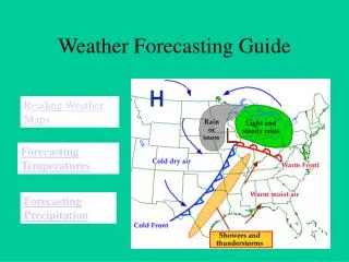
Weather Maps • Give a synoptic view of the weather showing simultaneous conditions over a large area.
Computers • Located at main forecasting centers. • Use models and statistical data to predict weather.
Sources of Weather Information • Flight Service Station (FSS). • Pilot’s Automatic Telephone Weather Answering Service (PATWAS). • Automatic Terminal Information Service (ATIS). • Transcribed Weather Broadcast (TWEB). • En Route Flight Advisory Service (EFAS).
Radar Summary Charts • Shows only precipitation. • Used mainly in pointing to areas of likely dangerous weather.
Surface Analysis Chart • Depicts pressure patterns, fronts, surface winds, temperature and dew points, restrictions to visibility, and other vital preflight planning.
Forecasting as a Service • Providing a Specific Service. • Forecasters must be prepared to give specific answers to specific questions. • Forecasting is not an exact science. • Aviators continually check weather conditions against predictions.
Forecasting as a Service • What the Forecaster Can Do. • Records show that the forecaster can predict the following weather information at least 75 percent of the time. - The passage of a fast-moving cold front within 2 hours of its arrival up to 10 hours in advance. - The passage of a warm front or a slow-moving cold front within 5 hours of its passage up to 12 hours in advance with 75 percent accuracy. - The rapid lowering of visibility in pre-warm front conditions within 4 hours of the time it occurs.
Forecasting as a Service - The beginnings of a thunderstorm within 1 or 2 hours of its arrival with the aid of radar. - The time that rain or snow will start falling within 5 hours of its actual arrival time. - The rapid deepening of a low-pressure center and its associated bad weather.
Summary 1. Weather People and Service 2. Weather Data Collection 3. Communicating Weather Data 4. Forecasting as a Service