Download
1 / 14
140 likes | 246 Views
Explore the rare and destructive Category Five hurricanes, their formation, intensity, and eye-opening characteristics, as well as the science behind their ultimate power and potential weakening. Delve into the essential ingredients and meteorological requirements that contribute to these powerful storms.

E N D
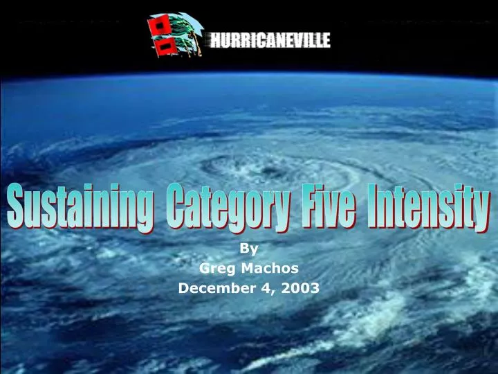
Sustaining Category Five Intensity By Greg Machos December 4, 2003
Agenda • Introduction • Hurricane Development • Essential Ingredients • Theories on Tropical Cyclogenesis • Category Five Hurricanes--Optimum Intensity • Requirements • What Happens Inside Category Five Hurricanes • Category Five Hurricanes--How They Lose Their Punch • Maximum Potential Intensity--Emanuel • Analysis of MPI--Persing and Montgomery • Causes of Weakening • Conclusion
Introduction • Hurricanes--A Combination of Beauty and Fury • Provide A Breathtaking View From Space. • Carry A Devastating Punch At The Surface. • Classifying Hurricanes--The Saffir-Simpson Scale • Categorizes Hurricanes In Terms of Wind And Pressure. • Ranges From Category One To Category Five Intensity. • Category Five Hurricanes--A Rare Breed • Account For Less Than 5% Of All Atlantic Hurricanes. • Also Represent Hurricanes At Maximum Efficiency. • Can’t Sustain Such High Intensity For Long. • Due To Changes In Its Environment and Within Itself.
Saffir-Simpson Scale* *Source: Ahrens, Meteorology Today, 2003
Long Lasting Category Five Storms* *Source: The Weather Channel, September 2003
Hurricane Development • Essential Ingredients • Sea Surface Temperatures at or above 26.5 0C. • Light Winds Aloft. • Plenty of moist air from the surface upward. • Rotation or spin--Forcing surface winds to converge. • Theories--Tropical Cyclogenesis • Organized Convection Theory. • Heat Engine Theory--Based on Carnot Cycle. • Combination of both theories. • Analysis--Heat Engine Theory Makes More Sense.
Organized Convection Theory* • Thunderstorms must be organized. • Cold air must be present aloft for instability. • Latent heat must be released at upper levels. • Latent heat at upper levels results in high pressure. • High pressure creates good outflow or exhaust for the storm. *Source, Ahrens, Meteorology Today, 2003
Heat Engine Theory* • Based on Carnot Cycle. • Transfers heat from warm ocean surface (warm reservoir). • To the upper levels of the troposphere (cold reservoir). • Transfer results from work done by small swirling air currents. • Pressure gradient results from temperature difference between the air aloft in the eye, and air aloft at periphery. *Source, Stull, Meteorology for Scientists and Engineers, 2000
Category Five Hurricanes--Optimum • Meteorological Requirements • Sustained Winds Exceeding 69 ms-1. • Minimum Central Pressure Below 920 mb or 0.91 atm. • Thermodynamic Requirements--Goldilocks Principle • Conditions are “just right.” • Sea Surface Temperatures Above 28 0C. • Adequately Moist Air at altitudes between 1.5 to 5 km. • Little or no wind shear at upper levels of atmosphere. • Rapid Intensification • Another characteristic of Category Five Storms. • Process takes hurricane from Cat 1 or 2 to Cat 4 or 5. • Occurs often in warm eddies, or deep, thick warm water.
Inside Category Five Hurricanes • Narrow and Well Defined Eye • Eye clear because of warm, sinking air in center. • Eye narrows to conserve momentum. • Classic Buzz Saw Shape • Combination of healthy outflow and organized CDO. • Outflow acts as exhaust for heat and moisture. • Organized Central Dense Overcast--Thunderstorms. • Essential for highly efficient heat engine to keep going. • Eyewall Replacement • Occurs in most major hurricanes. • Result of Rapid Intensification. • Can cause Concentric Eyewalls.
A Look At A Category Five Hurricane* Narrow Eye Central Dense Overcast Healthy Outflow *Source, NOAA, October 26, 1998
Ahrens, Donald C., 2003: Meteorology today: An introduction to weather, climate, and the environment. Thomson Learning, Inc. • Ban, Ray. 1992: Danger’s Edge. [Video] The Weather Channel. • Bister, M., and K.A. Emanuel, 1998: Dissipative heating and hurricane intensity. Meteorol. Atmos. Phys., 65, 233-240. • Elsner, J.B., and A.B. Kara., 1999: Hurricanes of the North Atlantic: Climate and society. Oxford University Press. • Emanuel, Kerry A., 2000: A statistical analysis of tropical cyclone intensity. Mon. Wea. Rev., 128, 1139- 1152. • Emanuel, Kerry A., 1999: Thermodynamic control of hurricane intensity. Nature, 401, 665-669. • Emanuel, Kerry A., 1988: The maximum intensity of hurricanes. J. Atmos. Sci., 45, 1143-1155. • Hoversten, Paul., 29 September 2000: “Scientists study why hurricanes intensify.” USA Today. [Online] http://www.usatoday.com/weather/huricane/science/whgascan.htm • Iacovelli, Debi., 1999: Concentric eyewalls of hurricanes: An interview with Dr. Hugh E. Willoughby. NOAA Mariner’s Weather Log, 43, 4-9. • Persing, J., and M.T. Montgomery, 2002: Hurricane superintensity. J. Atmos. Sci., 205, 5-50. • Remer, Fred., 2003: “Second Law of Thermodynamics.” [MS PowerPoint] University of North Dakota. • Stull, Roland B., 2000: Meteorology for scientists and engineers: Second edition. Thomson Learning, Inc. • Stewart, Stacy. 18 September 2003: Internet e-mail interview. • Wallace, J.M. and P.V. Hobbs. 1977: Atmospheric science: An introductory survey. Academic Press. • Willoughby, Hugh. 13 November 2003: Internet e-mail interview. References
Questions Feel free to use the next few minutes to ask questions.
Sustaining Category Five Intensity Hope you enjoyed the presentation.