SQL and SSQL
This document serves as a comprehensive guide to SQL (Structured Query Language) and SSQL (Spatial SQL) tailored for GIS professionals. It begins by breaking down the basic SQL commands, such as the SELECT statement and WHERE clause, and explains how to filter data using conditional operators. The introduction of SSQL highlights its ability to query spatial databases, allowing users to extract geographic features. Lastly, the guide includes recommended readings and exercises to enhance understanding of Spatial SQL's concepts and applications in Geographic Information Systems.

SQL and SSQL
E N D
Presentation Transcript
SQL and SSQL IT4GIS Keith T. Weber, GISP GIS Director, ISU
Definitions • SQL = Structured Query Language • SSQL = Spatial SQL • GPL = Graphical Presentation Language
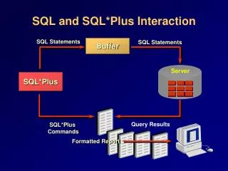
SQL- A Review • SQL is a simple language used to query (question) an ODBC-compliant database and retrieve data. • SQL is not simple or standard • S = structured
Structure • The most basic SQL statement is: • SELECT * from database.table • Let’s dissect this statement • SELECT is the command • * is a wildcard = everything and anything • Database.table is the target of the query
A Little More… • The previous SQL statement selected everything from a table • How do we select only a portion of a table? • The WHERE CLAUSE
WHERE CLAUSE • WHEREconditional operator • For example: • SELECT * from database.tableWHERECITY_NAME = ‘Pocatello’
Types of Conditional Ops • Simple (as in the previous example) • Compound • Let’s say we want to select and work with the records describing Pocatello and Blackfoot • We could select and work with them individually using two simple conditional operators…OR…
Combining Conditional Operator Expressions • Instead of: • SELECT * from database.tableWHERECITY_NAME = ‘Pocatello’ • …do some work, and then • SELECT * from database.tableWHERECITY_NAME = ‘Blackfoot’ • …do some more work
We Can Use… • A Compound expression combining two or more single expressions using either: • AND • OR • In our examples, which shall we use?
OR • SELECT * from database.tableWHERECITY_NAME = ‘Pocatello’ OR CITY_NAME = ‘Blackfoot’
Why OR? • Before a record (entity) is returned as a result of a query, the record must satisfy EACH WHERE clause if AND is used. • When OR is used, a record must satisfy only one of the WHERE clauses.
This is SQL • What is SSQL? • Spatial Structured Query Language • Or SQL for Spatially enabled relational databases • Oracle • Informix • IBM DB2 • MS SQL Server
An Example • SELECTresidence.geometry FROM residence WHEREType = ‘single family’ What is different about this expression? residence.geometry
Why is *.geometry important? • Until now, we have been returning all fields (SELECT * FROM…) • Now, we only want to see the geographic feature(s) returned by the query • To do that, we instruct SSQL to select the geometry (.geometry) of the TABLE of interest (residence)
GIS Layers are Tables? Data type for Geometry Spatial Grid Extent
Object Relational • OBJECTID inherited from Object class • SHAPE inherited from a class called Feature This could be “Boundary”
SSQL with Topology • Similar to intersect and union • These are conditional operators that are written into the WHERE clause
Key Concepts • SQL is highly structured • Spatial SQL builds upon SQL but remains within the general framework • SSQL requires an object relational, spatially enabled database • The *.geometry table is queried to return features • which are stored in the table as a LOB field • Along with other topological attributes
Questions? • Your assignment is: • Review basic SQL (if you feel it necessary) • Read Egenhofer’s early (1994) manuscript on Spatial SQL theory • Read the Spatial Data Extender white paper • Review the ArcGIS SSQL Help (use the link) • Complete the IBM DB2 SSQL exercise