Download
1 / 2
20 likes | 51 Views
Develop a suite of web-based tools to access, co-register, subset, and mine multi-sensor data for various scientific applications. Deploy in JPL, GSFC, and Langley DAACs.

E N D
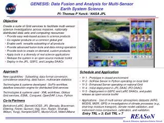
GENESIS: Data Fusion and Analysis for Multi-Sensor Earth System Science PI: Thomas P Yunck / NASA JPL Objective Create a suite of Grid services to facilitate multi-sensor science investigations across massive, nationally distributed data sets and computing resources: • Provide easy web-based access to science products • Co-register products on a common global grid • Enable swift, versatile subsetting of all products • Provide advanced fusion tools and data mining operators • Provide tools to create on-demand, custom products • Apply tools in a diversity of real science applications • Release the system in an open-source modular toolkit • Deploy in the JPL, GSFC, and Langley DAACs Insert project graphic in this quadrant… Approach New capabilities - Subsetting, data format conversion, coincidence searching, data fusion, multivariate statistics Technologies & systems developed - SciFlo workflow, dataflow execution engine for distributed Grid services Technologies & systems used - XML workflows, Globus Grid services, ESML, Conquest, OpenDAP, Linux, Python Co-Is/Partners Barkstrom/LaRC, Barnett/UCSD, JPL (Benada, Braverman, Eldering, Fetzer, Gunson, Hajj, Irion, Raskin, Shahabi, Wilson, Yung), Kempler/GSFC, Muntz/UCLA, Nittel/UMaine Schedule and Application • Yr 1 - Prototype in closed environment • Yr 2 - SciFlow Server in Python operating on local Grid • Yr 3 - Enhanced Server operating on national Grid • Yr 4 - Initial deployment in JPL DAAC (PO-DAAC) • Yr 5 - Deployment in GSFC and LaRC DAACs, and public release as open-source toolkit • Applications - Use of multi-sensor atmospheric datasets (AIRS, MODIS, MISR, GPS) in investigations of climate processes (e.g., strat-trop moisture transport), climate model validation, and instrument cross-comparison, calibration, and validation. Entry TRL = 3; Exit TRL = 7
Application of ESE Data and Tools to Particulate Air Quality Management PI: Stefan Falke / Washington University in St. Louis Objective The objective of this research proposal is to apply ESE data and tools to support air quality decision-making. This will be achieved through the use of existing monitoring data, innovative information technology, and established interoperability standards. The technology development portion of the project will extend and customize the application to end user needs using emerging web service technologies. Insert project graphic in this quadrant… Approach Highlights - Voyager spatio-temporal browser; Web service chaining; Aerosol watch system; data fusion; OGC wrapper for GCMD Technologies & systems developed – Web service chaining manager, data service wrappers (WMS/WCS), data browser tool enhancements (Voyager), catalog wrappers, aerosol watch dashboard application Technologies & systems used – Web services, AIRS, Voyager format, VIEWS, OGC WMS Co-Is/Partners COI / DaMassa, John / California Air Resources Board, COI / Khan, Maudood / Georgia DNR, COI / Tretheway, Ray / Sacramento Tree Foundation, COI / Kenna, Gordon / Georgia Cool Communities Schedule and Application • Milestone 1? • Milestone 2? TRLin = ?