Download
1 / 18
180 likes | 291 Views
Graduate Ethics Curricula for Future Geospatial Technology Professionals Dawn J. Wright Department of Geosciences Oregon State University David DiBiase Department of Geography & John A. Dutton e-Education Institute The Pennsylvania State University Francis Harvey Department of Geography

E N D
Graduate Ethics Curricula for Future Geospatial Technology Professionals Dawn J. Wright Department of Geosciences Oregon State University David DiBiase Department of Geography & John A. Dutton e-Education Institute The Pennsylvania State University Francis Harvey Department of Geography University of Minnesota Michael Solem Director of Educational Affairs Association of American Geographers D. Wright D. Dibiase F. Harvey M. Solem Award 0734903
U.S. Department of Labor highlights “geographic/geospatial technology” as key high-growth field for 21st century • $3.3 billion global market (Daratech, 2006) • Ethical issues loom large in public perception of the field • Surveillance and privacy • Social inequalities • Intellectual property rights • Citizen science, local activism GIS Profession: A Nascent Field
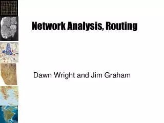
GREED, Envy, Wrath, Sloth, Gluttony, Lust, Pride Mapping the 7 Deadly Sins Average income vs. below poverty line Kansas State University Geography & Wired, 2009
Need to prepare GIS professionals for these challenges • UCGIS GIS&T* Body of Knowledge includes units on ethics among its 329 definitive topics *University Consortium for Geographic Information Science, Geographic Information Science & Technology • Recommended component at undergraduate, graduate, and professional levels • Needed as part of professional certification process (e.g., GIS Certification Institute) The Rise of Professional Ethics Education
Initial special topics, graduate seminars at OSU, PSU, Minnesota • Transition to permanent offerings • GEOG 864, Professionalism in GIS&T (PSU) • GEO 567, Responsible GIS Practice: Ethics for Future Geo Professionals (OSU) • GEOG 8291, GIS Ethics: Accuracy & Responsibility (UMn) • Develop model curricula and associated courseware • Disseminate open educational resources NSF Project Goals
Examine one’s own ideas of individual and professional responsibility • Recognize ethical implications of geospatial technologies and applications • Develop stronger and more sophisticated moral reasoning skills • Understand the “moral ecologies” of the various institutions and organizations making up the geospatial enterprise • Feel free to talk about ethics in the workplace Learning Outcomes of Courses
Intro readings: philosophy, moral reasoning • Review and discuss in-depth papers; group discussion and activities (e.g., role play) • Examine various codes of ethics • Interview training and analysis • Interaction w/ working professionals via interviews • Examine case studies • Prepare and present original case studies Pedagogical Approach
Mapping Muslim Neighborhoods: A police department’s plan to map potential terrorist enclaves brings charges of racial profiling. • Caribou Routes: A GIS analyst is asked to exclude pertinent data from maps prepared for a public hearing. • Cell Phone Tracking: Researchers track mobile phone users’ movements (w/o their knowledge) to derive predictive models of human mobility. • Submarine Crash: Inaccurate nav chart leads to deadly accident. Case Study Examples
Ethical sensitivity: Ability to identify and discriminate among ethical issues • Ethical knowledge: Familiarity with codes and rules • Ethical creativity: Ability to see “beyond the dilemma” (not all black & white) • Judgment: Increased likelihood that students will act appropriately (cannot be determined in class) Case Method: Assessing Student Learning
Each student does 1 interview • Develop original case from interview • Opens door for discussion of successful or failed approaches Interviews of Professionals
gisprofessionalethics.org Annotated bibliography, evaluation instruments
Outcomes UCGIS Model Curricula Vision Supporting Topics and Integrative Experiences GI S&T Body of Knowledge Core Learner
AM. Analytical Methods CF. Conceptual Foundations CV. Cartography and Visualization DA. Design Aspects DM. Data Modeling DN. Data Manipulation GC. Geocomputation GD. Geospatial Data GS. GI S&T and Society OI. Organizational and Institutional Aspects BoK Knowledge Areas
Unit GS6 Ethical aspects Ethics provide frameworks that help individuals and organizations make decisions when confronted with choices that have moral implications. Most professional organizations develop codes of ethics to help their members do the right thing, preserve their good reputation in the community, and help their members develop as a community. Ethics in the Body of Knowledge Topic GS6-1 Ethics and geospatial information • Describe a variety of philosophical frameworks upon which codes of professional ethics may be based • Discuss the ethical implications of a local government’s decision to charge fees for its data • Describe a scenario in which you would find it necessary to report misconduct by a colleague or friend • Describe the individuals or groups to which GI S&T professionals have ethical obligations Topic GS6-2 Codes of ethics for geospatial professionals • Compare and contrast the ethical guidelines promoted by the GIS Certification Institute (GISCI) and the American Society for Photogrammetry and Remote Sensing (ASPRS) • Describe the sanctions imposed by ASPRS and GISCI on individuals whose professional actions violate the Codes of Ethics • Explain how one or more obligations in the GIS Code of Ethics may conflict with organizations’ proprietary interests • Propose a resolution to a conflict between an obligation in the GIS Code of Ethics and organizations’ proprietary interests
Unit GS7 Critical GIS Many of the educational objectives used to define topics in this knowledge area, and in the Body of Knowledge 2006 as a whole, challenge educators and students to think critically about GI S&T. Since the 1990s, scholars have criticized GI S&T from a wide range of perspectives. Common among these critiques are questioned assumptions about the purported benefits of GI S&T and attention to its unexamined risks. By promoting reflective practice among current and aspiring GI S&T professionals, an understanding of the range of critical perspectives increases the likelihood that GI S&T will fulfill its potential to benefit all stakeholders. Philosophical, psychological, and social underpinnings of these critiques are considered in Knowledge Area CF: Conceptual Foundations. Ethics in the Body of Knowledge Topic GS7-2 Ethical critiques • Defend or refute the argument that the GI S&T professionals are culpable for applications that result in civilian casualties in warfare • Defend or refute the argument that the “digital divide” that characterizes access to GI S&T perpetuates inequities among developed and developing nations, among socio-economic groups, and between individuals, community organizations, and public agencies and private firms • Discuss the ethical implications of the use of GI S&T as a surveillance technology