Download
1 / 28
300 likes | 595 Views
Inland ENC. Content. Inland waterways Why are ENCs not sufficient? (voyage planning) Definition of Inland ENC S-100 approach New and copied features, attributes, enumerations Encoding Guide for Inland ENCs Usages and overlays Product Specification for Inland ENCs

E N D
Content • Inland waterways • Why are ENCs not sufficient? (voyage planning) • Definition of Inland ENC • S-100 approach • New and copied features, attributes, enumerations • Encoding Guide for Inland ENCs • Usages and overlays • Product Specification for Inland ENCs • Depth data and water levels • IEHG and IHO • Regulatory status • Coverage • Users of Inland ENCs
Inland waterways • Maritime navigation is governed by worldwide regulations of IMO, e.g. COLREG and SOLAS • Inland waterways (e.g. Mississippi, Amazon, Rhine, Danube, Volga, Yangtze, and all smaller navigable rivers and lakes) have specific features and specific regulations (specific signals, markings, and traffic rules, groins, groundsills, revetments, …) • The lower parts of the big inland waterways are used by both inland and maritime vessels • Inland ENCs need to meet the requirements of inland waterways, but should also be available for maritime vessels
The need for Inland ENCs • Waterborne traffic on inland waterways is not regulated by COLREG or SOLAS, but by regional or national regulations: • Europe: European Code for Inland Waterways (CEVNI) of the United Nations • USA: Code of Fed. Regulations 33 CFR • Russia: Rules of navigation along the inland waterways of RF • China and Brazil: a set of national and regional regulations • South Korea and Venezuela:national regulations • These regulations contain specificwaterway signals, signs and markings
Why Inland ENCs? • Objects such as bridges can only be encoded in a very basic form for maritime ENCs, but are extremely important for inland navigation • In inland navigation it is normally not possible to take another route, if there is a problem on the original route: detailed information is critical for voyage planning (e.g. dimensions and operating hours of locks and movable bridges)
Definition of Inland ENC the database, standardized as to content, structure and format, for use with inland electronic chart display and / or information systems operated onboard of vessels transiting inland waterways. An IENC is issued by or on the authority of a competent government agency, and conforms to standards initially developed by the International Hydrographic Organization (IHO) and refined by the Inland ENC Harmonization Group. An IENC contains all the chart information necessary for safe navigation on inland waterways and may contain supplementary information in addition to that contained in the paper chart (e.g. sailing directions, machine-readable operating schedules, etc.) which may be considered necessary for safe navigation and voyage planning. [IENC Encoding Guide, Edition 2.2, Feb 2010]
The S-57 S-100 approach • Inland ENCs are similar to ‘maritime’ ENCs, with a few exceptions: • Use of S-57 object classes, attributes and attribute values, as much as possible • Introduce new combinations of existing elements, when necessary • Include new features, attributes or enumerations, if necessary • Prior to the adoption of S-100, it was necessary to assign small case acronyms for S-57 object classes that were used with additional or new attributes/enumerations and for new elements • Small case elements will be replaced by elements from the HYDRO and the IENC domains in a future Product Specification, which will be based on S-101
Copied and new elements • The S-57 attribute VERDAT (vertical datum) only contains enumerations for vertical datums for maritime navigation • In inland navigation there are different vertical datums in use (e.g. Ohio River Datum, Russian Project Water Level, Reference Low water Level of Danube Commission, etc.) • Inland ENCs contain a copied attribute “verdat” with these additional enumerations • With this copied attribute it is also necessary to introduce a copied feature “m_sdat” • For some features that are not covered by S-57 it was necessary to introduce new features (e.g. notice marks) Features Attributes Enumerations
Encoding Guide for Inland ENCs • To ensure a common understanding and consistent encoding for all worldwide regions, there is a very detailed Encoding Guide for Inland ENCs (which replaces the section “Use of the Object Catalogue” of S-57) • See following example for the encoding of a bridge with bridge arches:
Usages • On major inland waterways, Inland ENCs are normally produced and used at a larger scale than ‘maritime’ ENCs • While the largest scale for ‘maritime’ ENCs is usage 6 (berthing), for Inland ENCs there are three usage codes: 7 - river 8 - river harbour 9 - river berthing
Usages Usage 8 Usage 7
Overlay cells • In some regions, different authorities are responsible for the maintenance of the waterway, and for the traffic regulation (e.g. buoys, beacons, notice marks, signals) • Depth information is extremely important on inland waterways (50 cm between keel and riverbed is normal) and in some areas depth are constantly changing • As such, it may be necessary to update the depth information much more frequently then the rest of the Inland ENC • Inland ENCs provide the possibility to use “overlay cells”
Overlay cells • Overlay cells do not contain skin of the earth features • They are displayed by an Inland ECDIS together with an Inland ENC of usage 1 to 9 • The Inland ECDIS uses the display priorities to compose the display • Producers have to agree on which non-skin of the earth objects are encoded in which layer + =
Product Specification for Inland ENCs • The Product Specification for Inland ENCs is based on IHO S-57, edition 3.1 • It contains the necessary amendments to enable the encoding of additional features for inland waterways • It describes the differences (e.g. in the cell header) that identify the cell as an Inland ENC, the usage, and so on • The Product Specification is comprised of the Feature Catalogue and the Encoding Guide for Inland ENCs
Depth data and water levels • Depth data in ENCs is based on a vertical datum, which is a horizontal plane • Depth data in Inland ENCs of rivers is referred to sloped and non-linear reference water level • The actual water level is irregular and can not be determined by tide tables. Instead, it has to be derived from water level gauges • Due to variations of the area of cross sections and the base slope of the riverbed different water levels are not parallel to one another • Water level models are needed to calculate the actual depth at a specific point of the waterway at a specific moment
Depth data and water levels • A standardized data exchange format is available to transmit the results derived from water level gauge readings and water level models to the on-board applications • This information can be used to display the actual water depth in the Inland ECDIS without changing the Inland ENC
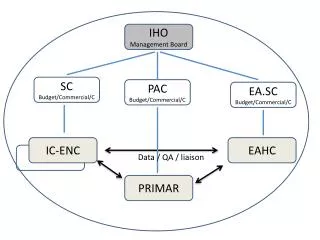
The Inland ENC Harmonization Group • Objective: to develop and to maintain a harmonized standard for Inland Electronic Navigational Charts (IENCs) suitable for inland navigation that is based on the standards of IHO for ‘maritime’ ENC • Guiding principle: to agree upon specifications for Inland ENCs that are suitable for all known inland ENC data requirements for safe and efficient navigation on inland waterways.
IEHG - recognition • As the competent international technical group on Inland ENC technical standards development, implementation and maintenance, IEHG is recognized by: • Europe - European Union and the Central Commission for Navigation on the Rhine • North America – US Army Corps of Engineers • Russian Federation - Russian Ministry of Transport • Brazil, Peru and Venezuela – Hydrography and Navigation Services • Asia – Transport Research Institute of the Ministry of Transport of PRC and KHOA of Republic of Korea • International Hydrographic Organization (IHO) • Because there are several countries with Inland Navigation that are not Member States of IHO, IEHG does not intend to become a member of IHO. • Instead, IEHG supports, advises and provides input to IHO regarding Inland ENC matters as a recognized NGIO.
IEHG – recognition (continued) • In 2009, IEHG has been recognized by IHO as a Non Governmental International Organization (NGIO) with observer status • Current members of IEHG are all European countries with connected inland waterways (17), Russian Federation, USA, Brazil, China, Republic of Korea, Peru and Venezuela
Regulatory status of Inland ENCs in Europe • The European Inland ECDIS Standard (includes the Inland ENC Product Specification and a performance and test standard for Inland ECDIS applications), has been adopted by • the United Nations www.unece.org(2007) • the Central Commission for Navigation on the Rhine www.ccr-zkr.org (2006) • the Danube Commission www.danubecommission.org (2008) • the European Union http://eur-lex.europa.eu/ (2013)Member states of the European Union are obliged to provide a complete coverage of the bigger waterways (class Va and above) within 30 months after the publication of the standard
Regulatory status of Inland ENCs • USA: The US Army Corps of Engineers (USACE) is responsible for the production and provision of Inland ENCs • Russian Federation: Federal task program on GLONASS development (Government regulation No. 587) includes the production of Inland ENCs for the inland waterways of Russian Federation (48000 km) • Brazil: The Directorate for Hydrography of the Brazilian Navy (DHN) is responsible for the production and provision of Inland ENCs
Coverage of Inland ENCs • USA: 20 inland waterways with 11 265 km have been covered with Inland ENCs • Russian Federation: 26 000 km of RF inland waterways have been covered with Inland ENCs • Brazil: DHN is capturing data for the production of Inland ENCs for approximately 4000 km of inland waterways • Europe: 10 250 km of inland waterways have been covered with inland ENCs • For more details see http://ienc.openecdis.org/
Users of Inland ENCs • There are more than 15000 users of Inland ENCs worldwide
Contact Chairpersons: Bernd Birklhuber, Austria, bernd.birklhuber@bmvit.gv.at Denise LaDue, USA, denise.r.ladue@usace.army.mil Flavia Mandarino, Brazil, flavia@chm.mar.mil.brWeijun Fei, China, fwj@wti.ac.cn Technical coordinators: Dr. Lee Alexander, University of New Hampshire, lee.alexander@unh.edu Pieta Kluytenaar, Serendipity UnLtd, p.kluytenaar@serendipity.nl Angel Terry, Jeppesen Marine, Angel.Terry@jeppesen.com Yong Baek, Korea Hydrographic and Oceanographic Administration, ybaek@korea.kr
Website:http://ienc.openecdis.org The websites provides the Terms of Reference, list of members, minutes of meetings and all the documents of the standards for download It provides a link to the discussion forum of IEHG The website also provides links to international organizations, national or regional authorities, and private companies who are dealing with Inland ENCs
Abbreviations COLREG Collission Regulations of IMO ECDIS Electronic Chart Display and Information System ENC Electronic Navigational Chart GLONASS Globalnaja Nawigazionnaja Sputnikowaja Sistema IENC Inland Electronic Navigational Chart IEHG Inland ENC Harmonization Group IHO International Hydrographic Organization IMO International Maritime Organization NGIO Non Governmental International Organization SOLAS Safety of Life at Sea Convention (IMO)