Download
1 / 2
20 likes | 126 Views
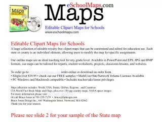
A large collection of editable royalty-free clipart maps ideal for education. Customize maps for assignments, reports, worksheets, and lessons. Available in various formats. Order online or download.

E N D
Editable Clipart Maps for Schools A large collection of editable royalty free clipart maps that can be customized and edited for education use. Each state or county is an individual element, allowing users to modify the map for specific assignments. Our outline maps are an ideal teaching tool for any grade level. Available in PowerPoint and EPS, JPG and BMP formats, our maps can be tailored for reports, student worksheets, projects, classroom lessons, and websites. To order go to: www.eschoolmaps.com order online or download an order form. • Single Unit $39.95 • check out our FREE samples • MultiUser/Site/Network Volume Licenses Available • PC Windows and MacIntosh compatible • Includes teacher take home privileges Map collection includes: World, USA, States, Globes, Regions, and Countries CIA World Fact Book Maps and Flags, plus over 150 jpg country maps, NASA space images For more information please visit www.eschoolmaps.com Or call Bruce Jones at 781-255-7179 • bruce@bjdesign.com Bruce Jones Design Inc., 661 Washington Street, Norwood, MA 02062 Thank you for your interest. Please see slide 2 for your sample of the State map
Sample USA State Map www.eschoolmaps.com WASHINGTON Columbia 5 River Spokane Lake River Chelan OLYMPIC NATIONAL Spokane PARK Seattle Columbia River Tacoma 90 Olympia MOUNT Yakima RAINIER River NATIONAL Snake PARK River 82 5 Columbia Vancouver River • Maps come ready to edit • Text is Grouped • Highways are Grouped • Rivers are Grouped • To customize you • need to Ungroup them. To Ungroup select with the pointer, choose Ungroup from the DRAW popup menu on the left of the Drawing bar at the bottom of the screen Use the BUCKET in the • Drawing tool bar to • fill the counties with color • Change Lines, add text, boxes, etc. • Holding down the SHIFT • Key will allow you to select • several objects at the same • time so you can pull them out or • color them. • To enlarge or reduce several • objects group them first. • Holding down the SHIFT Key • when you resize • will keep the map proportional • Delete this text box before customizing • www.eschoolmaps.com • For more info: 781-255-7179 Ungroup and Group is located in the DRAW popup menu located on the left of the Tool Bar below Color fills and lines located below in the Drawing Tool Bar