Download
1 / 18
180 likes | 311 Views
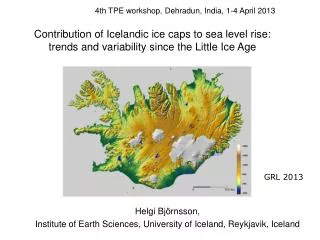
Basalt formations of the Skalamaelifell excursion, Reykjanes Peninsula, SW-Iceland and their relevance to the Weichselian glaciation of the peninsula. Leo Kristjansson, Institute of Earth Sciences, University of Iceland Agust Gudmundsson, JFS Geological Services, Reykjavik, Iceland.

E N D
Basalt formations of the Skalamaelifell excursion, Reykjanes Peninsula, SW-Iceland and their relevance to the Weichselian glaciation of the peninsula Leo Kristjansson, Institute of Earth Sciences, University of Iceland Agust Gudmundsson, JFS Geological Services, Reykjavik, Iceland A slightly amended version of a talk given at the Scientific Assembly of the European Geosciences Union, 20 April 2009, in a session commemorating Prof. Norbert Bonhommet and his discovery of the Laschamp geomagnetic reversal in 1967.
The Reykjanes peninsula is an area of active crustal rifting and volcanism. Width of the map : 60 km Red & pink : post-glacial Yellow : glacial, mostly hyaloclastite Map by J. Jónsson, 1983
In between the postglacial lavas, there are many hills and ridges of the order of 100-150 m in relief. These are largely of hyaloclastites, and are thought to have been mostly emplaced in the last (Weichselian) glaciation.Lava flows occur on top of many of the hills and ridges, and also within the hyaloclastites in some cases. The outcrops are generally a few m in thickness, and can be followed for some tens of meters. Skalamaelifell Excursion lavas Hyalocl. Intergl. lavas 11th cent. AD lava Interglacial lava sequences are found in various locations in the peninsula.
In a mapping project in the mid-1970s, Agust Gudmundsson noted the presence of intermediate remanence directions in lava flows in three hills east of the local village Grindavik.Since then, Leo Kristjansson has been sporadically collecting samples for laboratory studies of paleomagnetic directions at a large number of sites in the peninsula.By 1990, the presence of directions with low negative inclinations and westerly declinations was confirmed in lava flows (generally an olivine-rich variety) in several hills.The results provided support for the occurrence of short-lived geomagnetic excursions and reversal events in the Late Quaternary, as was first noted at Laschamp in 1967.
A paper on the Skalamaelifell excursion by Shaul Levi et al. in Earth and Planetary Science Letters in 1990 stated: • The mean direction in 97 samples was D = 258°, I = -15°, giving a VGP at 12°S in the Eastern Pacific. • The paleointensity was only 4.2 mT, in agreement with previous results by M. Marshall et al. at Bonhommet’s laboratory.This is confirmed in recent work by A. Ferk & R. Leonhardt presented in a poster at this session. • K-Ar ages on 9 samples from 7 hills by two laboratories gave an average age of 43 ka, s.d. 4 ka. No additional dates have been obtained on these sites since then.
If the current field strength in Iceland is representative for the Late Cenozoic field, it therefore seems that the paleo-intensity recorded at Skalamaelifell was unusually low. Evidence of geomagnetic excursions and short reversals is also very commonly found in the lava pile of 1 – 15 Ma age in Iceland. About 10% of all VGPs are below ±40° lat. Results from 5000 lavas of 1-15 M.y. age in Iceland show that the mean field strength there when the VGP was in low latitudes, was about ¼ of its strength when the VGP was in very high latitudes. See graph in the next slide.
Since 1990, a couple of new outcrops with similar excursion directions have been found in the same area.A mean direction from the above 97 samples plus another 49 samples from the same area, published by L.K. in 2003, is D = 261°, I = -16° (NB: only one or two cores per site).The a.s.d. of 14° is caused partly by rather poor stability and often low intensity of the remanence, as well as by the occasional occurrence of stubborn VRM, and possibly by minor movement of some of the outcrops.However, a contributor to this scatter could have been the presence of local magnetic anomalies. These now reach 1 mT at 900 m altitude (next slide), and they are probably due to remanence in rocks at depth.
Part of a map by T. Sigurgeirsson, published 1970
The hill F of up to 300 m relief is topped by lava outcrops with positive inclinations but southerly declinations. 33 sites give a VGP at 21°N on the W coast of N.-Africa In 2008-09, we intend to carry out new remanence direction measure-ments in up to 10 excursion locations. Preliminary results from the first 6 are in the next slide.
Inclinations of mean directions in six sites (results of two were combined); N = 6 to 11 cores in each mean, a95’s are 3 -7° Declinations are more clustered, at 260-266°. Do the differences in directions reflect age differences of the sites, or other factors ? Perhaps the local magnetic anomalies are a partial reason. Sites in H, A, V,... will be sampled soon. * -25° **-10° * -27° * -27° *-14°
We are ourselves even more interested in what the results tell us about the local geology, than in what they tell us about the geomagnetic field: • - The excursion outcrops may all have been emplaced in a time interval • < 1-2 centuries (cf. the Surtsey - Heimaey episode that took 10 years) • The excursion hills lie on 2-3 fissures, that were active simultaneously. • They produced lavas of fairly similar compositions, and probably belong • to a single extinct swarm • - The date of 43 ka is still the only available age determination from the • entire Late Quaternary volcanic succession in SW-Iceland • Along with other data, the excursion hills may give an idea of the glacial • conditions prevailing around their emplacement, see next two slides
The original version of this map and the sections to follow was published by A.G. in 1995
Enlarged cross-section on Line 1 of the peninsula, through mt. Fagradalsfjall (F) of the previous maps, with estimates of the shape of the glacier surface in late Weichselian time. The hatched areas indicate subaerially erupted lava caps. NW SE
A typical outcrop of a capping lava
An eroded hill of hyaloclastite, capped by a lava: Festarfjall on the S coast of the Reykjanes peninsula.The lava has a normal-polarity remanence direction. In the dry gully on the far left, there are several lava units with low-latitude reverse virtual geomagnetic poles. These lavas probably originated a couple of km to the north, in the low hill Siglubergshals.
Two views of hills in the central part of the Reykjanes peninsula, some with excursion directions