Download
1 / 95
960 likes | 1k Views
Explore the formation of coastal features, from fjords to wave-cut terraces, shaped by non-marine and marine processes. Learn about wave characteristics, generation mechanisms, and the dynamic nature of shorelines. Dive into the impact of waves and currents on energy transportation and coastal morphology. The forces shaping our coastlines are both geological and biological, creating a diverse range of coastal landscapes.

E N D
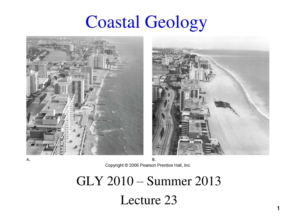
Coastal Geology GLY 2010 – Summer 2013 Lecture 23 1 1
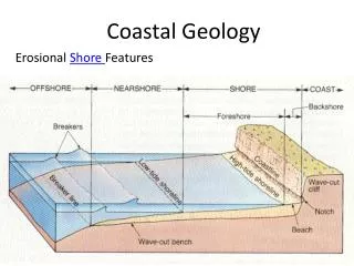
Coast • Entire land region bordering water - they extend inland until a different geologic setting is reached (plateau or mountain) • Dynamic zones, where change is constant 2 2
Interface • A boundary between different parts of a system • Transition zones between continent and ocean • Retreat of the coastline inward superimposes coastal features on pre-existing landscapes 3
Primary Coast • Coasts shaped by non-marine processes 4 4
Fjord Formation • Fjords drown coastal valleys scooped out by glacial erosion 5 5
Delta Formation • Deltas are formed by stream deposition, a non-marine process 6 6
Isostatic Rebound • Rebound following glaciation raised former beaches 7 7
Tectonic Uplift • Plate collisions may raise coast terraces 8 8
Carbonate Reefs • Growth of reefs can shape a coast 9 9
Secondary Coast • Coasts shaped by marine erosion or deposition 10 10
Wave Erosion • Breaking waves, especially when refracted, can shape a coast 11 11
Coastal Features - Headland • Created by wave cut benches breaking the force of waves, thus cutting the energy before the cliff is reached • Slower erosion produces a headland 13 13
Coastal Features - Cove • In the absence of wave-cut benches, water quickly erodes the rock - may also be the result of less resistant rocks 14 14
Platforms and Terraces • Wave erosion creates wave-cut platforms • Tectonic uplift or falling sea-level changes them to marine terraces 15
Straightening Coastlines • Waves perform a double action, simultaneously wearing away the headlands and filling up the bays or coves • USGS animation with sound – click to play 16 16
Coastal Features - Sea Cave • Formed in cove areas where waves pass unimpeded to the rock, battering and tearing away less resistant rocks 17 17
Sea Arch Formation • Further erosion can create a sea-arch 18 18
Coastal Features - Sea Arch • Formed by caves on adjacent sides of a headland joining 19 19
Sea Stacks • Collapse of the arch forms sea-stacks 20 20
Coastal Features - Sea Stack • Results from further erosion and collapse of the arch 21 21
Tombolo Formation • An off-shore sea stack protects the beach from wave action, sometimes allowing sand deposits to reach out to the sea-stack 22
Tombolo Photograph • Mont St. Michel in France 23 23
Depositional Features • Longshore currents deposit sand across bays, creating spits, bars, and hooks 24 24
Baymouth Bar Photo • A baymouth bar on the Michigan side of Lake Michigan • Cut through the bar is man-made • Photo: Steven Dutch 25 25
Coastal Spit and Hook • Northern tip of Cape Cod shows a well-developed hook, caused be refraction of waves around the spit • Photo: Steven Dutch 26 26
Spit Formation Video • A sand-spit has formed off the end of this breakwater (with sound) 27 27
Organic Coasts • Coasts formed by erosion or deposition in conjunction with active biological processes 28 28
Shoreline • Boundary between a body of water (marine or fresh water) and adjacent dry land 29 29
Waves and Currents • We will examine several aspects of waves and currents: • Energy Transportation • Wave generation • Wave characteristics 30 30
Energy Transportation • Waves and currents transport energy • Energy sources • Solar radiation • Gravity (tides) 31 31
Wave Generation - Wind • Winds moving over the surface of water pile the water up into waves • The stronger the wind, and the longer it acts on the water, the higher the waves • Hurricanes forming off the African coast are usually the strongest 32 32
Wind Driven Waves • Wind driven waves breaking on rocky outcrop 33 33
Wave Generation - Seismic Disturbance • Earthquakes can trigger seismic sea-waves (tsunamis) • Sometimes this happens because the earthquake generates underwater landslides 34 34
Wave Generation - Tidal Forces • The sun and moon exert gravitational forces on the earth • Water tends to pile up on the line between the earth-moon and earth-sun centers - thus producing “tidal waves” 35 35
Tidal Change Video • Time lapse animation of a changing tide • Tidal waves can be substantial in some areas (Bay of Fundy - 20 meters) and Puget Sound (3-4 meters) 36 36
Wave Characteristics – Parts of a Wave • Waves have two parts • The crest is the top of the wave • The trough is the bottom of the wave
Wave Characteristics - Measurements • Waveheight – Vertical distance between crest and trough • Wavelength – Horizontal distance between adjacent crests • Velocity - Distance a wave travels per unit time (30 to 90 km/hr in mid-ocean) 38 38
Refraction of Waves • Bending of waves as they approach a shoreline - waves refract so they are more nearly parallel to the shoreline 39 39
Wave Refraction Video • Video shows waves approaching a beach and their refraction (with sound) 40 40
Wave Types - Tsunami • Seismic sea-waves • Large wavelength and small waveheight in mid-ocean • Very large waveheight and small wavelength in coastal regions 41 41
Chile Tsunami, 1960 • One of the more destructive Pacific-wide tsunamis of our time was the Chilean tsunami of 1960 42 42
Aerial View of Tsunami Damage • Aerial view of the coastal area of Isla Chiloe, Chile 43 43
Tsunami at Hilo, Hawaii 44 44
Wave Types - Tides • Waves produced by gravitation interaction, principally with the moon • High tides on opposite sides of the earth • Tides move as earth rotates • Tidal range is the difference between high and low tides 45 45
Tidal Inlets • Tidal inlets are periodically flooded, followed by withdrawal of water 47 47
Wave Types - Rip Currents • Water moving toward shore goes over a barrier, such as a sandbar or reef • The lower-energy return flow is blocked, and channeled so that a strong current flows directly away from shore • Great for surfers wanting a fast ride to the breaker zone • Impossible to swim against - instead swim sideways to get out of the narrow flow 48 48
Rip Current Diagram • After a set of waves break, a lot of water and energy is pushed towards the shoreline • Displaced water will move along the beach with the long-shore current until it finds its way back out to sea 49 49
Spotting Rip Currents • Narrow, river-like, currents that have been fed by the long-shore current and sets of waves • Between 50 feet and 50 yards wide and can flow up to hundred of yards past the surfline • Rip current produce foamy and choppy surface • The water in a rip current can be dirty brown (from the sand being turned up) and moves rapidly out to sea 50 50