Hafize Gunsu Gemesi 1 (hggulden@iastate), Charles R. Hurburgh 2 (tatry@iastate)
GIS Based Agricultural Geo-Traceability Model. w w w. g r a i n l a b. o r g. Hafize Gunsu Gemesi 1 (hggulden@iastate.edu), Charles R. Hurburgh 2 (tatry@iastate.edu) 1 Department of Agricultural and Biosystems Engineering, Iowa State University, Ames, IA, 1,2. IOWA STATE UNIVERSITY.


Hafize Gunsu Gemesi 1 (hggulden@iastate), Charles R. Hurburgh 2 (tatry@iastate)
E N D
Presentation Transcript
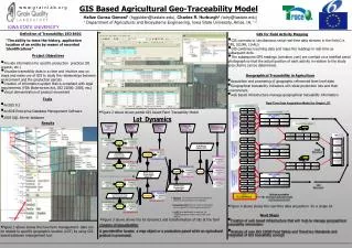
GIS Based Agricultural Geo-Traceability Model w w w. g r a i n l a b. o r g Hafize Gunsu Gemesi1(hggulden@iastate.edu), Charles R. Hurburgh2 (tatry@iastate.edu) 1 Department of Agricultural and Biosystems Engineering, Iowa State University, Ames, IA, 1,2 IOWA STATE UNIVERSITY Definition of Traceability: ISO 8402 GIS for Field Activity Mapping “The ability to trace the history, application location of an entity by means of recorded Identifications” • GIS connects to simultaneous serial real-time data streams in the field (i.e. GPS, SCUFA, 10-AU) • GIS combines incoming data and maps the readings in real-time as subsequent dots. • The subsequent GPS readings (combine, cart) are overlaid on a rectified aerial photograph so that the actual position of each activity in relation to the study area (Farm) can be determined. Project Objectives • Provide information for specific production practices (IP, organic, etc.) • Visualize traceability data in a clear and intuitive way on maps and make use of GIS to study the relationships between environment and the production parcels • Creation of information system that is compliant with legal requirements (FDA Bioterrorism Act, ISO 22000: 2005, etc.) • Visual demonstration of product movement Geographical Traceability in Agriculture • Acquisition and processing of geographic referenced farm level data • Geographical traceability indicators will relate production lots and their environment. • web based infrastructure manage geographical traceability information Tools • ArcGIS 9.2 • ArcSDE Enterprise Database Management Software • 2005 SQL Server database • Figure 2 above shows partial GIS based Farm Traceability Model Results • Figure 4 above shows the real-time data acquisition for a single lot Next Steps • Figure 3 above shows the lot dynamics and transformation of lots at the farm • Creation of web based infrastructure that will help to manage geographical traceability information Creation of Geo-identifier A geo-identifier locates a map object or a production parcel while an agricultural product is processed. • Figure 1 above shows the how farm management data can be related to specific geographic location (LOT) by using GIS based database management tool • Analysis of new ISO 22000 Food Safety and TraceCore Standards and integrated of GIS traceability concept