Download

1 / 11
110 likes | 130 Views
Learn how to apply TOPMODEL over the Mt. Sterling River Basin, OH, focusing on data collection, model calibration, and validation. Includes insights on model structure, assumptions, and data requirements.

E N D
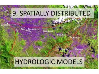
Modeling a Spatially Distributed Water Balance Using TOPMODEL Nduhiu
Introduction • Spatial Hydrology: • Spatial Hydrology is: • “the study of the motion of the earth’s waters and the transport of their constituents using the spatial data structures and functions of a geographic information system” (Maidment, R,D; 1997)
Topics of Discussion • I will be applying a modified version of TOPMODEL – TOPNET over the Mt. Sterling River Basin, OH. • This version, (adapted by David Tarboton), applies the classical lumped TOPMODEL over each sub-watershed in a river network.
Topic One • TOPMODEL assumptions: • Decreasing hydraulic conductivity with depth, • Saturated lateral flow driven by topographic gradient and controlled by depth to water table, • Steady state, saturated lateral flow related to equilibrium recharge rate.
Project Overview • Objectives: • Collect and prepare data to run TOPMODEL over the Mt. Sterling River basin. • Calibrate model using multi-objective criteria • Compare model output to existing stream flow and soil moisture data (model validation).
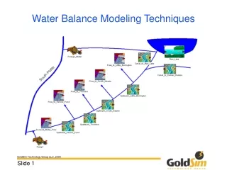
Model Structure • Schematic of model structure
Model Inputs • Data Requirements: • Elevation data (NED) – USGS • Stream flow data (NHD) – USGS • Vegetation data (LULC) – USGS • Soils data (STATSGO) – • Precipitation data (NEXRAD stage III) - • Energy forcing data – DMIP (UW)
Data Preparation • Stream network and elevation data • Prepare DEM (DEM reconditioning); • Fill sinks in DEM; • Run TauDEM for Stream network and Watershed delineation • Verify results.
Data Preparation cont. Vegetation • In Arc Toolbox convert to grid • In Arc Map, use spatial analyst raster calculator Soils • From STATSGO soils data, export coverage to shape file in Arc Toolbox. • In Arc map, add this to active data frame. • Program fitf (Ross Woods, 2001) is then used to compile soils information for input to TOPMODEL.
Data Preparation Precipitation • NEXRAD Stage III precipitation data OHRFC. • Process 12 months of stage III radar data to create a year long file. • Run make_raindat.exe to process raw radar data • Energy forcing data • Two data files created for use with TOPMODEL; • i) temper.dat – temperature(ºC), • Dew Point temperature, date & time. • ii) clipar.dat – Latlong of Basin center, temp. gage elevation, monthly diurnal temp. range.
TopSetup • Run from within TauDEM and compiles spatial data to be used in TOPMODEL. • Model parameters distributed over the basin by subwatershed.