Download
1 / 21
210 likes | 302 Views
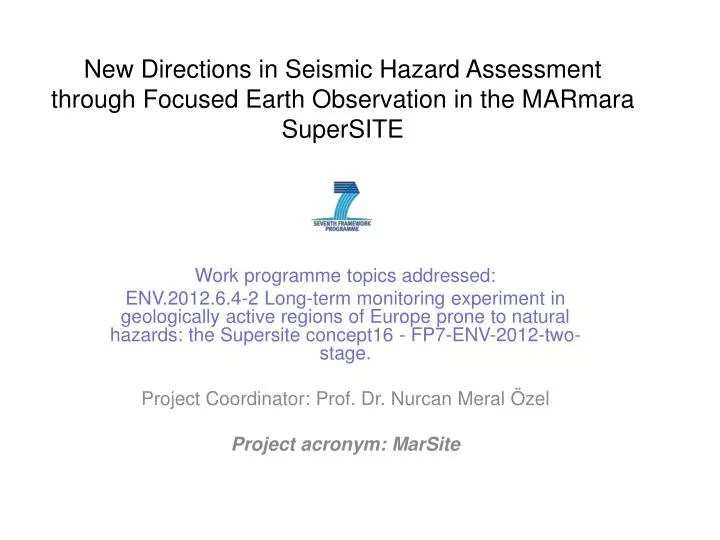
New Directions in Seismic Hazard Assessment through Focused Earth Observation in the M AR mara Super SITE. Work programme topics addressed:

E N D
New Directions in Seismic Hazard Assessment through Focused Earth Observation in the MARmara SuperSITE Work programme topics addressed: ENV.2012.6.4-2 Long-term monitoring experiment in geologically active regions of Europe prone to natural hazards: the Supersite concept16 - FP7-ENV-2012-two-stage. Project Coordinator: Prof. Dr. NurcanMeralÖzel Project acronym: MarSite
B) The seismicity of the Marmara Region from combined catalogues of KOERI and TUBITAK (1964-2011, M≥2.5). Instrumental observation infrastructure of Marmara A) The occurrence years and possible locations of historical earthquakes .
The MARsite projectproposes to identify the Marmara region as a ‘Supersite’ within European initiatives to aggregate on-shore, off-shore and space-based observations, comprehensive geophysical monitoring, improved hazard and risk assessments encompassed in an integrated set of activities to respond to all priorities identified in the ENV.2012.6.4-2 call.
OBJECTİVES MARsite aims to: 1) harmonize geological, geophysical, geodetic and geochemical observations to provide a better view of the post-seismic deformation of the 1999 Izmit earthquake (in addition to the post-seismic signature of previous earthquakes), 2) investigate loading of submarine and inland active fault segments and transient pre-earthquake signals, related to stress loading with different tectonic properties in and around Marmara Sea. 3) explore earthquake/landslide triggering mechanisms and tsunami hazard modelling. 4) obtain rapid source-mechanism solutions and slip models, 5) develop new algorithms for early warning and rapid-response studies, 6) establish a risk management cycle with the creation of a link between the scientific community and end users. 7) to develop novel geo-hazard monitoring instruments including high-resolution displacement meters, novel borehole instrumentation and sea-bottom gas emission and heat-flow measurement systems, in association with the relevant industrial sectors and SMEs.
MARsite WPs JICA-JST Meeting, 26 June 2012 7
MARSite The monitoring of the 'Supersites' should be conducted through a fully integrated conceptual approach based on collaboration with existing monitoring networks and international initiatives, developing new instrumentation such as in-situ sensors, and aggregating space and ground-based observations (including from subsurface), and geophysical monitoring. The project(s) will develop and demonstrate the next generation of geo-hazards monitoring/observing systems, and contribute to establishing comprehensive natural hazards observatories through a cross-cutting approach. MARsite will use the power of -dense seismological, geochemical and GPS networks -experts on PSInSAR and SBAS analysis -combination of the remote-sensing and ground-based data -developing and demonstration of new systems -Integration of different data sources, uses of data etc. -early warning and rapid response system for Istanbul -Real-time data provision during crisis period (e.g. aftershocks)
MARSite Geological Geophysical Models .Collection of Multidisiplinary Data from avaliable networks .Developing of new systems .Contribution of SMEs The projects will establish a chain from observations to end users. The outcomes will be applied to the phases of the risk management cycle relevant for this region. Hazard estimation Optimization of Risk Cycle under this project Risk Studies&Vulnerability Estimation EVENT Links to end users &Risk Mitigation Harmonzation&Re-evaluation of the avaliable data Collobrative efforts in the frame of the Marsite
Work Packages Coordinaton and link to other projects Data from available networks, Satellite data/Harmonization and modeling for hazard studies To develop new technologies and methodologies
Work Packages To estimate real time hazard To study the triggering between natural hazards, experiences from 1999 eq. (Avcilar) To create a link to end-users To understand the Marmara tectonics and upgrade the avaliable models
the locations of borehole (red star) earthquake recording stations (triangles are permanent KOERI stations; rectangles are TUBITAK temporary stations and red circles are the surface array stations, which will be installed in the frame of this project)
Establishment of Borehole Observation System and High Resolution Seismic Studiesin the Western part of the main Marmara Fault in the frame of a EU-FP7 project titled as MARSITE
MARsite will adopt Advancing GEOSS Data Sharing Principles • MARsite will adopt Advancing GEOSS Data Sharing Principles and will incorporate related GEOSS strategic targets defined as “Provide a shared, easily accessible, timely, sustained stream of comprehensive data of documented quality, as well as metadata and information products, for informed decision making….” in GEOSS Strategic Targets - Document 12 (Rev,1), page 8. • The high level Data Sharing Principles represents on of the foundations for GEOSS, and their effective yet flexible implementation remains a major challenge. MARSite will be a good chance to experiment their application. The 10-year implementation plan sets out the GEOSS Data Sharing Principles: • There will be full and open exchange of data, metadata and products shared within GEOSS, recognizing relevant international instruments and national policies and legislation • MARSite partners will actively share their data among themselves, through suitable tools such as the shared repository on the project web site, and will experiment and tune the data sharing models and interfaces that will potentially be used for data sharing at large within the GEO Supersite iniziative
Outcomes of the MARsite project: .Geodetic monitoring of 4D deformations in order to understand earthquake cycle processes, to develop probabilistic earthquake forecasting models and to constrain the seismic hazard models in the Marmara region; • High resolution data acquired by a new generation deep multidisciplinary complete digital borehole seismic station; • Rapid and quantitative ShakeMap scheme by implementing finite-source descriptions and calibrating with multiple geodetic/seismic data; • Characterization of activated and reactivated Deep-seated Gravitational Slope Deformations (DGSD) determined through the integration of geological and geomorphological analyses with high-resolution DInSAR; • Knowledge on the distribution of active structures in the Marmara Region and the amount of motion they localize; • Geophysical, seismological, physical and geochemical data from automatic sea-floor devices (e.g. OBS, Piezometers, acoustic station and multidisciplinary SN4-type observatory) including data from periodical cruises for water column sampling and laboratory analyses, for seafloor degassing measurements; and • Results on earthquake early-warning (EW) and rapid-response systems in the Marmara Region (Istanbul) with the addition of a pilot landslide monitoring and EW system and introduction of new space technologies for monitoring and assessment of vulnerabilities. • Therefore, MARsite will surely have an important impact on the regional response for seismic risk prevention, but also plays a scientific/technical significant role as a European supersite.
JICA-JST Project (Japan-Turkey) • Theme 1: Seafloor Observations for Earthquake Source Models in the Marmara Sea Region • Subgroup 1.1: Long-term sea-bottom seismic observation • 1.1.a Micro-Earthquake activity • 1.1.b Stress field evaluation • 1.1.c Seismic tomography • Subgroup 1.2: Electromagnetic observation • Subgroup 1.3: GPS-acoustic observation • Subgroup 1.4: Geo chemical studies (water chemistry, radon, temperature, gas exhalations, current etc. • Theme 2: Estimation of Strong Ground Motion for Earthquake Source Models • Subgroup 2.1: Micro-tremor observation and subsoil structure • Subgroup 2.2: Observation of strong ground motion • Subgroup 2.3: Theoretical estimation of ground motion • Theme 3: Experimental Study of Building Response to Strong Ground Motion • Theme 4: Forecasts of Earthquake and Tsunami Occurrences in the Marmara Sea Region • Subgroup 4.1: Incorporation of seafloor seismic data into Earthquake Early Warning (EEW) • Subgroup 4.2: Simulation of large earthquake occurrence along the North Anatolian Fault beneath the Marmara Sea and estimation of possible rupture parameters • Subgroup 4.3: Tsunami simulations and hazard assessment. • Subgroup 4.4: Tsunami monitoring • Theme 5: Understanding of historical large earthquakes at on-land branches of the western part of the North Anatolian Fault • Subgroup 5.1: Trenching studies • Subgroup 5.2: InSAR studies • Theme 6: Effective Dissemination of Earthquake Hazard Information • Subgroup 6.1: Earthquake monitoring in the Yalova-Izmit-Bursa-Sakarya area • Subgroup 6.2: Rapid information with collaboration of mass-media • Subgroup 6.3: Hazard and risk assessment with collaboration of administration • Subgroup 6.4: Disaster Education Program
JST superiority object Istanbul& Local regions around Marmara Sea ⇒ Nationwide in Turkey Implementing the proposed disaster prevention plan by Turkish Government Objective of JST Project Proposing a Disaster Prevention Plan against Marmara Earthquake on the basis of scientific research analyses Awareness training and disaster prevention plan against Marmara Earthquake 100% Creating reference materials for disaster education and for disaster prevention countermeasures Broadcasting the preliminary information through mass-media, telecommunication and internet ⇒Rapid response in the case of a disaster Improvement of hazard maps and visualizations Visualization Numerical modelling Development of rapid analysis process Visualization 80% source region of the anticipated Marmara earthquake Seismic assessment: Seismic evaluation considering retrofitting and seismic isolation Analysis of the anticipated Marmara earthquake and tsunami generation process Evaluation of linkage of the anticipated Marmara earthquake based on the estimated source region Information disseminationStudy Committee ・ Prediction of building Vibration ・ Evaluation of existing structures Extraction of necessary information from rapid analysis 60% Development and enlargement of the numerical simulation Estimation of the source region Disaster education program and organizing the Content Theoretical prediction of strong ground motion of the anticipated Marmara earthquake Integration of land and sea data: ・Shape of fault and bathymetry ・Friction characteristics・Plate motion velocity・Historical seismic activity Disaster experience.Reflect the regional issues 40% Estimation of fault shapes and fault brunches beneath the Sea of Marmara based on integrated data Identification of the vibration characteristics of buildings based on design documents and experimental study Estimation of subsurface structure Regional disaster prevention community Integration of the data observed in (sea bottom) and around (land) the Sea of Marmara Preliminary numerical simulation Of tsunami and earthquake cycle⇒ extraction of lack of data Determine each regions needs and problems 20% Microtremor and earthquake observation in and around the existing buildings (schools, hospitals, etc.) Disaster management symposium Numerical modeling of the active Faults beneath the Sea of Marmara based on the existing observational data Japan-Turkey Joint seafloor observatory On the ground surface (around the building) In the building 1st Floor and Top Floor Sharing experiences of earthquake – tsunami victims from Japan and Turkey 0% 2. Tsunami prediction based on earthquake scenarios 3. Seismic characterization and damage prediction 4. Disaster education using research resultvisuals 1. Earthquake Source Model
Boğaziçi UniversityKandilli Observatory and Earthquake Research Institute Thank you yThank you...