Download
1 / 1
10 likes | 145 Views
ANALYZING GLACIAL TILL: AN INQUIRY-BASED PROJECT FOR HIGH SCHOOL EARTH SCIENCE STUDENTS. Kurtz K. Miller 1,2 and Alex C. Cook 1 1 Department of Teacher Education, University of Dayton, Dayton, OH 45469 2 Department of Educational Leadership, Miami University, Oxford, OH 45356. Introduction

E N D
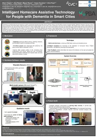
ANALYZING GLACIAL TILL: AN INQUIRY-BASED PROJECT FOR HIGH SCHOOL EARTH SCIENCE STUDENTS Kurtz K. Miller1,2 and Alex C. Cook1 1 Department of Teacher Education, University of Dayton, Dayton, OH 45469 2Department of Educational Leadership, Miami University, Oxford, OH 45356 Introduction ●The fact that Quaternary glacial deposits, including glacial till, are widely distributed throughout much of the Midwest makes it possible for high school earth science teachers to instruct students about how glacientic sediments help geologists to interpret climatic conditions during the Pleistocene. This poster presentation will outline an inquiry-based, glacial till project conducted with junior and senior high school earth science students at the Miami Valley Career Technology Center (MVCTC) in Clayton, Ohio. Results – Group #1 Glacial Till Site Location – Holes Creek Park, Centerville, Ohio ●Glacial till for the inquiry-based project was collected from Holes Creek Park, which is part of the Washington-Centerville Park District, Centerville, Ohio. The outcrop location is within easy walking distance of Alex-Bell Road – the road visible in the site aerial photograph. ●To further understand the last ice advance, Cook (2007)1 studied the till provenance of two tills at Holes Creek. By determining where the clasts in the till matrix came from a flow line and distance of travel analysis was made. Clastswere analyzed by rock type, shape, size, and roundness to show statistical differences in two different till layers found at the outcrop. The results demonstrate that the two till layers may be from two different depositional events. One idea that fits well with the data is that the upper layer is a melt out till and the lower layer is determined to be a lodgement till. 1 Cook, A.C. (2007). Unpublished Senior Thesis, University of Dayton, Dayton, Ohio. Results – Group #2 Figure 1: The relative location of Holes Creek. Holes’s Creek, Washington Township-Centerville Park District Park Here Glacial till outcrops. Holocene alluvium sitting On top of a layer of glacial till. Figure 2: Google Earth image showing Holes Creek. Student Data ● The earth science students were amazed to discover that student-collected data could help them to draw conclusions about how the Ice Sheet moved, what it picked up, and how it operated. ● The grains of the rocks became more rounded the further they traveled in the till matrix - the igneous and metamorphic rocks. The erraticswere rounded and the local bedrock in the till was more angular. The larger clasts tended to be the local bedrock since it didn't get a chance to be broken down by the glacier over hundreds of miles of travel in the ice. The Glacial Till Project ● MVCTC junior and senior earth science students were asked to compile a “cheat sheet” of common geomorphic glacial features, including but not limited to bullet boulders, erratics, glacial grooves, glacially polished surfaces, glacial striations, and tillites. ● Next, students were challenged to determine the “characteristics” of glacial till. Each student group received a 1 – 2 liter bag of glacial till. ● Each group had access to a set of sieves, grain size cards, hand lenses, and grain size shape cards. ● Students independently developed strategies to determine the “characteristics” of glacial till, and then they plotted the collected data using Microsoft Excel. Conclusions ● The glacial till, inquiry-based project empowered earth science students to draw connections between the shape, genesis, and composition of till clasts and how the Pleistocene Ice Sheet moved through the Miami Valley in Southwestern Ohio. Figure 3: One group of MVCTC earth science students displaying a bag of glacial till, a glacial erratic boulder, and a preserved Late Pleistocene stick. References ● National Research Council (NRC). (2012). A Framework for K-12 Science Education: Practices, Crosscutting Concepts, and Core Ideas. Washington, D.C.: National Academies Press.