Height Mod in Kentucky
180 likes | 200 Views
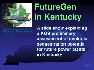
Kentucky's Height Modernization Program enhances geodetic control for accurate heights using GPS, allowing for various applications such as floodplain management and infrastructure monitoring. The program aims to establish control points, develop accurate Digital Elevation Models, and provide accessible products statewide. Funding and responsibilities are split among various agencies to ensure successful implementation.

Height Mod in Kentucky
E N D
Presentation Transcript
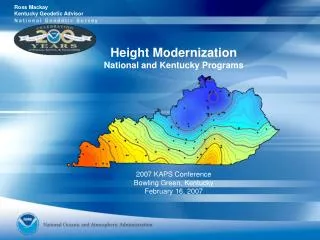
Ross Mackay Kentucky Geodetic Advisor Height Mod in Kentucky Height Modernization Forum Flint, Michigan January 26, 2006
National Height Modernization Program Kentucky Height Modernization Program
National Height Modernization Program • Significant time savings in field surveying using GPS • Accurate determination of floodplain boundaries • Precise control for digital ortho imagery • Accurate control for reliable Digital Elevation Models • Improved elevation control for GIS base maps • Subsidence monitoring in mining and karst regions • Infrastructure monitoring (e.g. dam and floodwall) Height Modernization will provide accurate, reliable heights using GPS with traditional leveling. • Facilitate mapping and planning for • Floodplain management • Homeland Defense • Economic Development Falmouth, KY - 1997 The Cincinnati Enquirer
National Height Modernization Program FY06 funding
Kentucky Height Modernization Program 10,461 benchmarks remain in NGS database 20 % reported “not found” or in “poor condition” 23 % in last 25 years were reported as “good” Only 12 % reported as “good” in last 10 years NSRS benchmarks in Kentucky
Kentucky Height Modernization Program Congressman Hal Rogers October 25, 2004 "I am pleased to announce today that Kentucky will receive funding for Height Modernization in NOAA’s fiscal 05 budget." and in FY06 too!
Kentucky Height Modernization Program • The goal of the Kentucky Height Modernization Program • is to bring accurate and reliable heights • to any location in the Commonwealth at any time. • The realization of this goal has three Phases: • Establishment of geodetic control to improve the regional geoid model and provide a reference frame for surveying and remote sensing measurements. • Development of an accurate Digital Elevation Model (DEM) from data collected by Light Detection and Ranging (LIDAR) and calibrated to the geodetic control. • Creation of products which make the geodetic control and DEM accessible to a broad range of users, by packaging it with state-wide digital orthophotography.
Kentucky Height Modernization Program H = Orthometric Height(elevation) N H = h - N h = Ellipsoidal Height (from GPS) N = Geoid Height (from Geoid model) Topographic Surface H h N Geoid Geoid03 Ellipsoid GRS80
Kentucky Height Modernization Program Kentucky regional geoid model
Kentucky Height Modernization Program FY 2005 Appropriation $492,829 Responsibility split between National Geodetic Survey & Morehead State University KY Div of Geographic Information Kentucky Transportation Cabinet CORS antenna poured concrete post mount
Kentucky Height Modernization Program • Division of Responsibilities • Morehead State University • Grant recipient from NOAA. • Submit application and project reports for Grant, • Develop Kentucky CORS Data Archive Center. • KY Division of Geographic Information • Provide overall Height Modernization Project management • Develop project charters, plans and agreements, • Coordinate with related organizations such as the flood map modernization committee. • Kentucky Transportation Cabinet • Install and provide ongoing support of the CORS sites (to be located at Highway District Offices) • Manage the award of contracts and oversight of the work. CORS antenna building wall mount
Kentucky Height Modernization Program National CORS Morehead State U. CORS (National CORS in December 2005) KY Transportation Cabinet CORS (KY-HMP FY05)
Kentucky Height Modernization Program in FY 2006 $498,101 Begin leveling to FBN and CORS
Kentucky Height Modernization Program in FY 2006 Begin leveling to FBN and CORS
DEM - Digital Elevation Model Kentucky Height Modernization Program in FY 20?? LIDAR and it’s Products
Ross Mackay Kentucky Geodetic Advisor ross.mackay@noaa.gov on the web at ngs.ky.gov (502) 573-0189 x3473