Download
1 / 20
200 likes | 303 Views
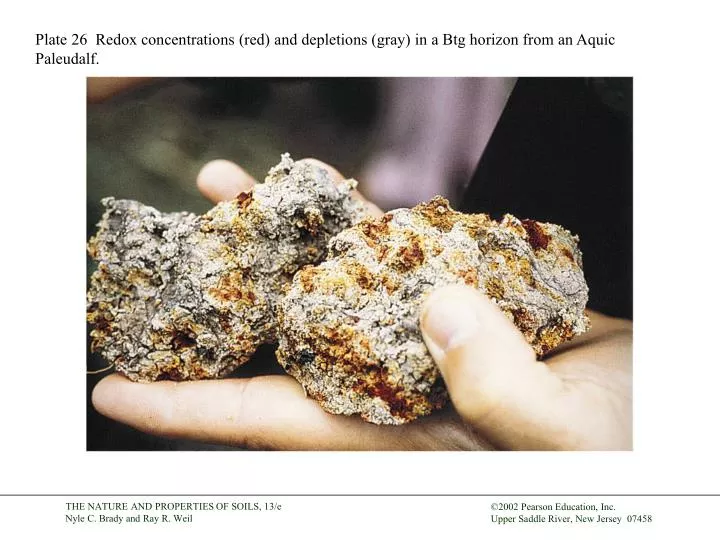
Plate 26 Redox concentrations (red) and depletions (gray) in a Btg horizon from an Aquic Paleudalf. Plate 27 The waxlike ped surfaces in this Bt horizon from an Ultisol are clay skins (argillans). Bar = 1 cm.

E N D
Plate 26 Redox concentrations (red) and depletions (gray) in a Btg horizon from an Aquic Paleudalf.
Plate 27 The waxlike ped surfaces in this Bt horizon from an Ultisol are clay skins (argillans). Bar = 1 cm.
Plate 28 Erosion of convex sites by tillage and water has exposed red B-horizon material.
Plate 29 Oxidized (red) root zones in the A and E horizons indicate a hydric soil. They result from oxygen diffusion out from roots of wetland plants having aerenchyma tissues (air passages).
Plate 30 Dark (black) humic accumulation and gray humus depletion spots in the A horizon are indicators of a hydric soil. Water table is 30 cm below the soil surface.
Plate 31 Urban soils (referred to by some as Urbents) often hold surprises in their profiles. Here a tree planting hole reveals a buried A horizon (top) and buried asphalt (lower).
Plate 32 Soil saturated beyond its liquid limit by torrential rains caused a landslide and mudflow that pushed huge tropical cloud forest trees downslope like toothpicks and demolished a village at the foot of this mountain in Honduras.
Plate 33 The red, kaolinitic soil in the foreground was hauled in to build up a stable roadbed across this low-lying landscape in South Central Tanzania. The black soils are rich in expansive clays, which would break up the pavement if used for the subbase.
Plate 34 Mass wasting of clayey soils on steep slope may occur when saturated with water, as in this rotational block slide in East Africa. Note man in center for scale.
Plate 35 Two large soil stockpiles on a construction site. The brown A horizon was set aside for landscaping topsoil; the redder B horizon (back) was stockpiled for use as fill and road base.
Plate 36 An uneven layer of silt blankets a glacial deposit of coarse sand and gravel in this Rhode Island Inceptisol. The profile water-holding capacity varies with the thickness of the silt, causing an irregular pattern of drought-stricken turf grass (inset).
Plate 37 Influence of soil fauna on microstructure in O (left) and A (right) horizons of a forested Ultisol in Tennessee. Particulate organic matter (POM) includes leaf fragments (lf), fecal pellets (fp) and root fragments (rf).
Plate 38 Roots from sweet pepper plants follow organic-matter-lined earthworm burrows through the compacted B horizon of a Pennsylvania Inceptisol. Earthworm activity was encouraged by 15 years of no-till practices and cover crops.
Plate 39 Plant roots grow along the gleyed coating of a fragipan prism whose reddish interior is too dense for roots to grow. The roots are squeezed flat between the prisms.
Plate 40 This cicada nymph, nestled 60 cm deep in the B horizon of a forested Ultisol, will feed on oak tree roots for several years before emerging as an adult. Free water in the macropore bathes the cicada, whose burrowing promotes drainage and enhances root growth.
Plate 41 Traditional humid-region farmers use slash-and-burn systems. They chop down patches of forest and burn the dead vegetation, returning many nutrients in the ash. Note fire in the background and burned logs in the foreground of this Sri Lankan woman’s new clearing. See Section 20.7.
Plate 42 Drought-stressed grass shows importance of soil depth. The rectangular area of brown grass is underlain by a shallow (25-cm) layer of soil atop the roof of an underground library. The trees and green grass at right grow in deeper soil.
Plate 43 The soil on the left of this hydrangea was limed, that on the right was acidified (with FeSO4). After a year, blue flowers formed on the low-pH side, pink on the high-pH side.
Plate 44 Leaves from near the bottom of nitrogen-deficient (yellow tip and midrib), potassium-deficient (necrotic leaf edges), and normal corn plants. All the leaves came from the same field.
Plate 45 This iron-deficient azalea was sprayed with FeSO4 on one side 3 days before being photographed. Soil pH higher than 5.5 can induce such iron deficiency.