Download

1 / 141
1.41k likes | 1.43k Views
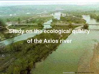
This study examines the water quality of the Axios River using benthic macro-invertebrate samples, physicochemical variables, vegetation survey, and river habitat survey. The river is impacted by human interference and pollution from urban centers, industries, and agricultural activities. The study aims to estimate the ecological quality of the river and propose management strategies.

E N D
Study on the ecological quality of the Axios river www.corinthia-net.gr/ecology/axios.htm
THE TEAM Introduction: Phillip Buckley and Eva Mourgi Materials and Methods: Janina Welsch and Frederic Mineur Evzoni: Sabina-Raluca Datcu and Joan Oudry Axioupoli: Vasilis Dakos, Lina Tzimiri and Danai Paleologou Gorgopi: Alexander Dzubaj and Markos Sarris Katanti: Silvia Markova Overview: Silvia Markova, Phillip Rogers and George-Dragos Zaharescu Statistics: Christos Koukoumidis and Simon Burandt Discussion: Giorgos Anasontzis, Thibault Vannier and Vasilis Dakos Management: Fotis Sgouridis
CONTENTS Slide number 4- 12: Introduction 13- 22: Materials and Methods 23- 89: Results 90- 91: Orders and families in each station 92- 94:Comparison between the water quality of the stations in 1997 and 2000 95- 110: Overview 111- 119: Statistics 120- 134: Discussion 135- 137: Managerial Proposals 138- 140: Bibliography 141: Acknowledgements
Introduction Many of the streams and rivers in the European Union suffer from the anthropogenic effects of abstraction andpollution. Many countries of the EU employ specialized organizations to undertake regular monitoring of running waters (e.g. the Environment Agency in the U.K.). Greece isone of the EU countries that does not have a national or regional monitoring network (Lazaridou et al. 2000). In the present study an attempt was made to estimate the water quality of the Axios river. This was doneusing benthic macro-invertebrate samples, physicochemical variables, a vegetationsurvey and a river habitat survey. This river was chosen because in addition to the natural variation found between upland and lowland river sites there were obvious areas of interference by man. http://www.fourmilab.ch/cgi-bin/uncgi/Earth?i mgsize=320&opt=-z&lat=37.9667&ns=North& lon=336.267&ew=West&alt=29&daynight=-d& img=learth.evif
Study Area General Description The Axios River has its source in the Sar mountains in the Former Yugoslavian Republic of Macedonia (FYROM). The river runs for 320km, of which 240km are in FYROM. The remaining 80km of the river run through Greek territory. Most of the water in the river is drained from FYROM, with only 5% of the water introduced to the river coming from Greece (Argiropoulos, 1991). The river flows south-east, entering Greek territory through a gently undulating plain and discharging into the sea at the Thermaikos Gulf. The Axios estuary, with the estuaries of the rivers Aliakmon and Loudiascreate a wetland of great importance. This wetland is protected under both the RAMSAR convention (1971), and the “Natura 2000” directive of the European Union (Lazaridou, 1998).
Land Uses • The Greek part of Axios river system can be divided into three regions according to the human activity on the land through which it flows. • The first 20km of the river in Greek territory, from the border to Polikastro is primarily used for drinking. • Thesecond region which extends from the city of Axioupoli to the demarcation line between the cities of Kilkis and Thessaloniki is used for agricultural irrigation. • The final region leading to the Gulf is mainly utilized for industrial purposes (Agiropoulos 1991, Pitsavas and Ganidou, 1996). 1 2 3 Fragma Ellis dam http://egnatia.ee.auth.gr/~akalatha/thmap.htm
The main channel is obstructed by the Fragma Ellis dam, 40km downstream of the border, next to the town of Koufalia. This dam provides water to an extensive network of irrigation channels from May to September (Argiropoulos, 1991). • In addition to removal of water from the river there is also extensive abstraction of sand. The river deposits annually approximately 3.500.000 m3 of sand, this extends the delta into the sea at a rate of 30m annually (Argiropoulos, 1991). • In the agricultural land that borders the river several different crops are grown: 28.4% of the land is used for cotton, 22.2% for corn, 21.3% is given over to orchards, 12.3% is used for rice, 3.6% for tobacco, and 12.2% for other vegetables (Albanis et al 1994). • This places a heavy abstraction strain on the river.
Sources of Pollution The Axios river accepts waste from Polikastro, Axioupoli and Koufalia. These are the largest urban centres in the region. Polikastro and Axioupoli are also the industrial centres for the area. Several tributaries of the river also introduce pollution. Approximately 2km above the Fragma Ellis dam, the Anthofito channel deposits municipal and industrial effluent into the main channel (Lazaridou, 1998). The Vardarovasi ditch takes effluent from Koufalia. Agricultural waste is also introduced to the river both through drainage channels and contaminated ground water. The main sources of pollution are shown in the following table (Lazaridou, 1998):
Sampling stations • The sample sites were chosen according to the physical characteristics, land use and accessibility. Four sites weresampled over the course of one day. • The first site was approximately 1km below the border with FYROM, near the village of Evzoni. The sample area was adjacent to agricultural land and characterized by low vegetation. The site was not significantly influenced by anthropogenic activities in Greek territory and was chosento demonstrate the quality of the water coming from FYROM. • The second station was located 20km from the Greek border, near Axioupoli. Three samples were taken from this site. One sample was taken from a channel (canal in) leading into the main channel. 50m above this sample site the channel accepted the effluent from an abattoir. The second sample was taken from the main channel (mainflow) immediately upstream of a mature island, just above the entrance of the channel. The thirdsample was taken from the outflow of the same channel (canal out). Station two was chosen because it examined the first major pollutionoccurrence in Greek territory. (Lazaridou 1998) Sand was also removed from the river at this site.
The third station was located on the Gorgopi river, a tributary that runs into the main channel 25km from the border. This station was characterized by rich bank side vegetation, small width and depth and high flow. The tributary is thought to accept some agricultural waste from nearby land, but is notheavily polluted by runoff from the land (Lazaridou, 1998). Four samples were taken at this site. The first sample was taken 10m down stream of a weir and 20m downstream of a bridge (downstream) The second sample was taken just above the bridge and just below a side channel (middle).The third sample was taken just above this source (upstream). A final sample was taken in a side channel (side channel). This site waschosen toexamine the quality of the water that comes from the Gorgopi river to the Axios river. • The fourth station was located near the village of Anatoliko, 1km from the point were the Vardarovasi ditch discharges into the Axios river, and approximately 64km from the border. This site was characterized by thick, low vegetation. One sample was taken from this site. The site was chosen because it is located below both the third main source of pollution, the Vardarovasi ditch and the Fragma Ellis dam.
Materials and Methods Sampling of Macroinvertebrates The first three sites were sampled using a 3-minute kick-sweep method (Armitage et al., 1983) with a standard pond net (surface 575 cm2, mesh size 90 μm, depth 27,5 cm). During these three minutes all kinds of substrate habitats were sampled. For special habitats like big stones, tree roots or wooden debris a supplementary 1-minute sampling (by hand) was carried out, according to the relative frequency of these habitats. At Katanti – Anatoliko, due to the depth, a 3-minute sample was taken standing on the riverbank. A standard pond net was used for agitating the ground while it was pulled towards the bank.
3 minute kick-sweep method Photo:Maria Lazaridou
The samples were stored in plastic bottles and fixed in 4% formaline. In the laboratory the samples were washed using a 50 μm mesh sieve and then sorted with the aid of magnifying lenses. All invertebrates were identified to the family level using a stereoscope. They were preserved in ethanol.
Physicochemical parameters The following physicochemical parameters were measured in situ using a digital multimeter: temperature, total dissolvedsolids (TDS), pH and dissolved oxygen (DO2). Relative abundance of each category of substrate (boulders, cobbles, pebbles, gravel, sand, silt, clay) was estimated visually according to the Wentworth scale. Water velocity was measured at the sampling stations using a flow meter. Discharge was calculated using measurement of velocity and depth at each tenth of the width of the river.
Physicochemical analysis Photo:Maria Lazaridou
Statistical analysis Three multivariate analyses known as FUZZY (Equihua, 1990), CANOCO (Ter Braak 1988) and PRIMER (Field 1982) were used to obtain both ordination and classification. FUZZY is a clustering technique. It was chosen because it is suited for ecological analysis where there is no clear-cut transition from one class to another. It does not assume the existence of discrete benthic populations between the various stretches of a river system. Instead, it identifies the continuum and gradual change in their faunal composition (Equihua, 1990). The relationships between the macroinvertebrate taxa [transformed by ln(x+1)], physicochemical parameters and sampling sites were analyzed using the Canonical Correspondence Analysis (program CANOCO).
The statistical package PRIMER was used to compare the similarity between the different invertebrate communities. First, a Dendrogram was formed to amalgamate the sites into groups according to similarity of their benthic communities. Then a second part of PRIMER, known as SIMPER took the results of this dendrogram and expressed the similarities and differences, as a percentage, between these groups.
Bioticscores The Biological Monitoring Working Party (BMWP) score (Chesters, 1980) and the Greek Evaluation System (GES) (Artemiadou, unpublished) were performed on all biotic data in order to evaluate the water quality.The BMWP take into account the presence/absence of families whereas the GES take also into account the abundance of each family. *ASPT IS REFFERED AS BMWP INDEX Sampling of macrophytes Macrophytes were collected between the riverbanks along a transect (5 m width) around sampling stations. According to the size and access of the station plants were reported only on one river side and partly on the substrate of the channel. Abundance was estimated visually.
River Habitat Survey At the first three sites an evaluation of the habitats took place, using the River Habitat Survey field method, or RHS (Environment Agency UK, 1997). The RHS field method is a systematic collection of data associated with the physical structure of watercourses based on a standard 500m length of a river channel. Observations were done at an interval of 50m (spot-checks). Physical features were assessed from 1m wide transect across the channel while vegetation structure, land-use and channel vegetation types were assessed within a 10m wide transect. In addition the general habitat of the channel and the management of adjacent land-use were reported (sweep up).
Finally, cross-section measurements of water and bankfull, bank height and water depth were made at one representative location. For each site the Habitat Quality Assessment (HQA) score was evaluated, according to the 1.2 version. This score is based on the presence and extent of habitat features of known wildlife value recorded during the survey. At the same time the Habitat Modification Score (HMS) was also calculated (version 1.1). This score expresses the extent of artificial modification to the physical structure of the channel. Afterwards the sites were categorized according to the 6 HMS categories used in the UK (Raven et al ., 1998).
HMS:6 Predominantly unmodified HQA:57 R.H.S.-EVZONI
RHS-EVZONI The first site at Evzoni was located on a symmetricalfloodplain with a channel width of about 90m and banks that reach from 1 to 5 meters. This morphology, along with the fact that the predominant material consists of gravel and pebbles almost at the full extent of the channel and at the reach studied, is responsible for its rippled surface, meaning there is a general downstream flow with disturbed rippled surface(run). Glides and riffles are also reported as well as marginal deadwaters but very restricted. The vegetation in the channel is limited to 3 different types, mainly at the banksides. Deposition features, such as point-, side- and mid-channel bars, (vegetated and not) had also a dominant presence at this site.
The banks have a physical profile, mostly undercut and steep, although there are reinforcements at the toe, because of gabions at various locations. The bankfaces have vegetation mostly on the right side with occasional clumps of trees, underwater roots and woody debris. The banktops on the other hand are uniform with tall herbs or bare earth predominate. Land-use beyond the banks is dominated by field and agricultural land.
EVZONI VEGETATION Shown here are two profiles, one transect covering the riverbank and a cross profile at Evzoni. The vegetation characteristics of Evzoni were mainly grasses and herbs. Where the survey was conducted, over-grazing had occurred by sheep.
Terestrial vegetation (EVZONI) Herbs 15% Grasses 35% Unvegetated 50%
Station 1 - Evzoni Xanthium strumarium Paspalum paspaloides www.agralin.nl/prosroni/paspalum.html * All the photos (except those taken from the Internet) are from Polunin Oleg, Oxford University,1969, Flowers of Europe Myriophyllum spicatum
The high discharge and various substrates could explain the high percentage of Hydropsychidae and Caenidae and the presence of Heptageniidae. According to both indices Evzoni is characterized as a site of good water quality.
HMS:7 Predominantly unmodified R.H.S.-AXIOUPOLI HQA:52
RHS-AXIOUPOLI The second site at Axioupoli was also located on a symmetrical floodplain with a channel width of about 86m and banks that reach up to 2 meters. The predominant material consists of gravel and pebbles almost at the full extent of the channel and at the reach studied, and the flow is smooth, meaning there is just a perceptible flow (glide) with disturbed rippled surface because of the wind. Runs and riffles are also reported, as well as marginal deadwaters. The vegetation in-channel consists of 4 different types limited at the banksides. Deposition features are also important such as side bars and a mid-channel one but the predominant in-channel feature is a big mature island which actually divides the river in a main channel and a side one, where extensive filamentous algae persists in an anoxic environment.
The banks have a physical profile, mostly steep, but they have also gentle parts which lead to side bars poached by animals or exploited for sand-abstraction. There are reinforcements at the toe because of gabions at various locations. On the bankfaces there are isolated trees which affect the channel moderately by their underwater and exposed roots. The banktops are bare with a road along them. Land-use beyond the banks is dominated by tall herbsand agricultural land. A major pollution source from an abattoir was recorded, also litter instream, a roadbridge, nests of birds at the eroding earth cliffs of the banks as well as dragonflies.
AXIOUPOLI – Canal In Terrestrial vegetation cover was sparse. It is likely that this is a result of the substrate. However, there had been modifications to the channel flow. Gravel had been moved and disturbed the substrate. In this section of the river, pollution was high, as a result of the abattoir discharge. The presence of freshwater plants was rare and was mainly represented by filamentous algae.
AXIOUPOLI – Main flow The presence of terrestrial vegetation was dependent upon various factors. These factors were predominantly disturbance from grazing and river flow. At certain parts of the year the side bar could be under water, as a result of higher water level. The substrate was mainly fine gravel. Water retention along the shore surface was poor. The presence of larger macrophytes was low.Filamentous algae was predominant.
Terestrial vegetation (Axioupoli - Main flow) Grassees Unvegetated 30% 50% Herbs 20%
AXIOUPOLI (Canal out) Further along the canal-out at Axioupoli, greenslime was present. Terrestrial plant forms were again low nearer to the riverbank, however trees were present further back.