Download
1 / 34
340 likes | 572 Views
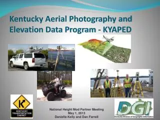
Kentucky Aerial Photography and Elevation Data Program - KYAPED. National Height Mod Partner Meeting M ay 1, 2013 Danielle Kelly and Dan Farrell. KYAPED Program Information. This initiative will provide statewide elevation data (LiDAR) and color leaf-off aerial photography.

E N D
Kentucky Aerial Photography and Elevation Data Program - KYAPED • National Height Mod Partner Meeting • May 1, 2013 • Danielle Kelly and Dan Farrell
KYAPED Program Information This initiative will provide statewide elevation data (LiDAR) and color leaf-off aerial photography. The multi-million dollar project is expected to span a three to four year period which began in January 2012. Funding partners for this effort have include federal agencies such as the Federal Emergency Management Agency (FEMA), the Department of the Interior (DOI) U.S. Geological Survey (USGS), the USDA Farm Services Administration (FSA), and the USDA Natural Resources Conservation Service (NRCS), as well as local governments and several state agencies. The Kentucky Transportation Cabinet (KYTC) is a major partner in this effort. More information regarding the Digital Aerial Photography and Elevation Data Program including agency uses, partner listings, wiki definitions, specifications, and data examples can be found on the program website @: http://kygeonet.ky.gov/kyfromabove/
Why KYAPED? This program will provide significant savings to government and the private sector by using a common basemap, avoiding duplication, and encouraging the standardization of Geographic Information Systems (GIS) assets throughout the Commonwealth.
Kentucky Aerial Photography & Elevation Data (KYAPED) Program Program Goals • • To acquire statewide leaf-off color aerial photography for the entire Commonwealth • • To acquire high-resolution elevation data for the entire Commonwealth • • Pool funding resources from Local, Regional, State, and Federal Agencies
2012 Program Partners • •Kentucky Transportation Cabinet (KYTC) • • Kentucky Division of Abandoned Mine Lands (AML) • • Kentucky Division of Geographic Information (DGI) • • Kentucky Division of Water (DOW) • • United States Geological Survey (USGS) • • National Geospatial Intelligence (NGA) • • Boone County Planning Commission (BCPC) • • Frankfort Plant Board (FPB) • • Louisville-Jefferson County Information Consortium (LOJIC) • • Northern Kentucky Area Planning Commission – LINK GIS • • Fort Knox • • Hardin County • • Kentucky State University (KSU)
2012 Program Status • • All priority areas have been delivered on schedule • • Review has been completed on 11 of the 12 Priority Areas • • 100% of the LiDAR data collected has been delivered • • All Program Partner data has been distributed • • Image Server Services are being created as final data is received • • The remaining data is being staged for distribution processing
2013 Program Plans • • Program will focus on extreme Western Kentucky • •There will be NO Federal Funding in 2013 • • City of Florence will acquire 6 inch imagery • • Paducah/McCracken County is doing a full buy-up (Elevation & Imagery) • Program Partners for 2013Kentucky Transportation CabinetDivision of Geographic InformationPaducah/McCracken CountyCity of Florence
Specifications LiDAR http://kygeonet.ky.gov/kyfromabove/pdfs/Specs_LiDAR_Production.pdf Orthophotography http://kygeonet.ky.gov/kyfromabove/pdfs/Specs_OrthoPhoto_Production.pdf Collection: NAD83(CORS96), NAVD88, Geoid 09 Project Deliverables: Kentucky Single Zone
Additional Considerations • Staff – DGI • The main thing this project has consumed is time. Lots of time. Everything from Project Management to Imagery Review to creating ArcGIS Server Services and everything in between. DGI estimates that it takes 1.5 staff members to manage the data. • Storage Requirements • DGI has increased its SAN storage from 10TB to over 26TB and have invested in 20TB of portable storage as well.
TYPICAL QUESTIONS WHEN USING LIDAR DATA • Why LiDAR? LiDAR generates an accurate 3D model of the earth’s surface. GPS provides the 3D position. What’s the Accuracy? In open, flat areas, ground contours can be recorded from an aircraft flying overhead providing accuracy within 6 inches of actual elevation. In steep, forested areas accuracy is typically in the range of 1 to 2 feet and depends on many factors, including density of canopy cover and the spacing of laser shots. What’s the difference between "raw" LIDAR data and "classified" LIDAR data? The points of the "raw" LIDAR data include elevations for the ground, buildings, highway overpasses, forest canopy, and anything else that the laser beam encountered. In data processing, each of these points is classified into one of the LAS classification values.
What Classification are we using for modeling a surface? Model Key-Point!
ADVANTAGES OF LIDAR OVER TRADITIONAL PHOTOGRAMMETRY AND CONVENTIONAL SURVEYING • Ease of data acquisition • Increased ability to determine surface elevations in difficult areas and less time for creation of elevation data • Less dependent of weather, time of year, time of day • The speed and accuracy of LiDAR make it feasible to map large areas with the kind of detail that before had only been possible with ground survey crews. • LiDAR data (point cloud) is easily used with GIS software and can be used with Microstation
Returns Multiple LIDAR Returns 1 2 3
What about the Breaklines? LiDAR technology, however, does not inherently collect the breaklines necessary to produce traditional DTMs. Breaklines have to be developed separately through a variety of techniques, and either used with the LiDAR points in the generation of the DTM, or applied as a correction to DTMs generated without breaklines. Mobile Mapping and Stationary Scans datasets are highly accurate. Howeverbreaklines from Traditional Survey methods are ready for use, while Breaklines from Mobile Mapping and Stationary Scanning are extracted in post processing. Note: Manual editing is necessary to produce a Quality LiDAR project.
Breaklines collectedEdge of Pavement, Crown, Edge of shoulder, Curb, Median, Ditches, etc
Merged Airborne LiDAR surface with collected field data to make 1 surface
Highway Design Comments • As with traditional photogrammetry, specific features can added to the DTM from field surveys such as utilities, UST, retaining walls, drainage structures TG/IE, etc. • These features are added as-normal by using "survey edit" on the existing DTM. The “point cloud” inside the perimeter of the ground survey is re-triangulated to include the ground survey features. Control points utilized from original LIDAR (KY Single Zone) should be the control points for the ground survey. • Depending on the accuracy of the LIDAR data, the DTM could be more accurate by reducing the contour interval. File sizes and RAM may become an issue on workstations.
CONTACT INFORMATION AND LINK • Contact Information • Inquiries regarding the Commonwealth's • Aerial Photography & Elevation Data • Program can be directed to: • Thomas Rossman, Director • Commonwealth Office of Technology, • Office of Application Development, • Division of Geographic Information • 100 Fair Oaks Lane • Frankfort, KY 40601 • (502) 564-6412 • Thomas.Rossman@ky.gov • http://kygeonet.ky.gov/kyfromabove/
QUESTIONS? REFERENCE LINKS http://technology.ky.gov/gis/Pages/default.aspx • http://kygeonet.ky.gov/kyfromabove/ • http://liaisons.usgs.gov/geospatial/ • http://www.fema.gov/national-flood-insurance-program-flood-hazard-mapping/map-modernization#1