Download
1 / 22
280 likes | 555 Views
Basic Geography Review. Ms. Crone 2012. Basic Geography Review. Relative and absolute location Types of maps Physical and political Basic Geography info Continents and oceans Basic vocabulary Hemisphere, equator Geographic Coordinate System

E N D
Basic Geography Review Ms. Crone 2012
Basic Geography Review • Relative and absolute location • Types of maps • Physical and political • Basic Geography info • Continents and oceans • Basic vocabulary • Hemisphere, equator • Geographic Coordinate System • Latitude and longitude, Prime Meridian, Equator, International Date Line
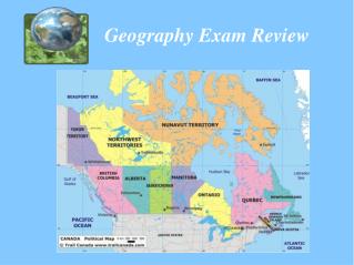
Types of maps • There are many different types of maps. Types of maps and projections: • Physical maps • Cultural maps • Political maps • Population maps • And many more.. • A map projection is any method of representing the surface of a sphere or other three-dimensional body on a plane.
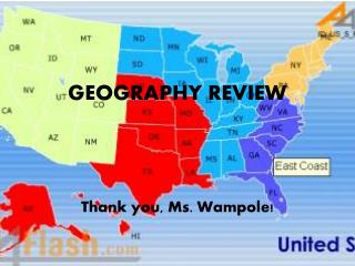
Map 31 of 76 The US and Canada with Political Boundaries
Map 29 of 76 The US and Canada: Physical Map
Map 32 of 76 The US and Canada with Population Density
Map 33 of 76 The US and Canada with Economic Activities and Resources
Map 34 of 76 The US and Canada with Natural Hazards
Map 10 of 76 World Map: Political with Climate Zones
Map 11 of 76 World Map: Political with Ecosystems
Basic vocabulary • Hemisphere- ½ of the earth • Northern and Southern, Eastern and Western
Basic Vocabulary • Equator- The imaginary great circle around the earth's surface, equidistant from the poles and perpendicular to the earth's axis of rotation. • Cuts the earth into the Northern and Southern Hemisphere
Latitude [aka parallels] • Latitude is the measure of how far north or south a location is from the equator. • Measured in degrees by how far away from the equator (North or South) a place is. 66½o N 23½o N 0o 23½o S 66½o S
Longitude [aka meridians] • Longitude is a measure of how far East or West a place is from the Prime Meridian. • Prime Meridian = 0o (Greenwich, England) • International Date Line 180o • All lines to the right of the PM is East, and all lines to the left are West.
Relative and Absolute Location • Relative location- a places location compared to another place • West of Fruitvale • Absolute location – a place’s position on the globe, the geographic coordinates of the place • (33o N, 95o W) • One absolute location, many relative location
How to find a place using its coordinates. (33o N, 95oW) 1st number is the latitude- how far north or south of the equator a place is 2nd number is the longitude, how far east or west of the Prime Meridian a place is So, this means this location is in the northern hemisphere and is west of the prime meridian
Now, Lets Practice… • 40° N, 73°W • New York • 30° N, 31° E • Cairo, Egypt • 33° S, 151° E • Sydney, Australia • 35° N, 139° E • Tokyo, Japan • 33° S, 18° E • Cape Town, South Africa • 51° N, 0° W • London, UK • 34° N, 118° W • Los Angeles, CA