Download
1 / 35
350 likes | 467 Views
Merging census aggregate statistics with postal code-based microdata. Laine Ruus < laine.ruus@utoronto.ca > University of Toronto. Data Library Service 2008-12-03, revised 2010-04-20 <http://www.chass.utoronto.ca/datalib/misc/dli_training_2010/PCCF_2010.ppt>. This session will cover:.

E N D
Merging census aggregate statistics with postal code-based microdata Laine Ruus <laine.ruus@utoronto.ca> University of Toronto. Data Library Service 2008-12-03, revised 2010-04-20 <http://www.chass.utoronto.ca/datalib/misc/dli_training_2010/PCCF_2010.ppt>
This session will cover: • Setting up the original file of postal codes • Decisions the researcher has to make • Extracting census geography from the Postal code conversion file (PCCF) • Things to consider when merging the output from the CHASS PCCF interface, and your file of postal codes
The process, briefly, is: • Extract census geography from the PCCF for the area covered by the survey postal codes • Merge with the original survey data, based on the postal codes. • Extract required census variables (eg from profile files) with census geography ids • Merge with the original survey file which now includes census geography, by census geography ids • There are a number of different ways of doing this. This is one of them.
What is the PCCF? • Postal codes have no direct spatial existence • Postal codes represent where residents receive their mail, not where they live • The PCCF contains one record for each postal code-dissemination block pair, with all other census geographic codes, and some Canada Post management variable for each dissemination block • The PCCF contains no census data.
We start with the researcher’s file of postal codes. Often, the users file of postal codes looks something like this, eg an Excel file with other variables that need to be preserved in the final output file. Note that all these records include a 'Centre' variable. We will use that Information later.
First the file needs to be sorted by postal code, any errors fixed, and then sorted again…
Next, check for duplicate postal codes in the file. You just need to know they are there – you will see why later. Note, in this example, we have rural and urban postal codes as well as duplicate postal codes.
Load the file into SPSS and save it as a system file, Eg postal_codes.sav. SPSS can read an .xls file. Note the variable name of the postal code variable (‘Postalcode’), its type (string) and its width (8)
Now some decisions have to be made: • Which census is closest to the time that the data were collected? (here we assume 2006) • Date of survey collection determines which census year • Date of census determines date of census geography. I.e. a survey done in 2009 needs 2006 census geography so as to link 2006 census statistics; but a survey done in 1992 needs 1991 census geography.
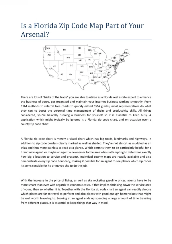
Decisions (cont’d) • How much of Canada does the survey cover: urban areas only, or rural areas as well (we have rural areas in this example)? • 'B1A' thru 'B5A' are urban FSAs; 'B0E', 'B0H', etc are rural FSAs • If only urban areas are included in the file, the user can use census tract level statistics • If urban and rural areas are included, the user must use dissemination area, or CSD level statistics, or even FSA level
Dissemination area (DA) level: • Covers all Canada • Available back to 1961 (computer-readable form only) • Smallest population for which statistics are released by STC • Most likely to be suppressed because of population size or data quality • Most susceptible to distortion when aggregating to higher levels of geography
Census tract (CT) level: • In 2006, available for 33 CMAs, and 15 (of 111) CAs only • Available back to 1951 (in print) and 1971 in computer-readable form • Less likely to be suppressed for reasons of population size or data quality • Less susceptible to distortion due to random rounding
If you are working with earlier files, with no dauid, eauid, or ctuid variables You can compute them: • Eauid (pre 2001)= ((prov*1,000,000)+(fed*1,000)+ea)) • Dauid (post 1996)= ((prov*1,000,000)+(cd*10,000)*da)) • Ctuid=((CMACA*10,000)+ctname))
Once these decisions have been made: • We know which PCCF file to use, • And which geographic identifiers to use (in this example, Dauid) • The CHASS census analyzer provides access to 3 postal code conversion files, containing 1996, 2001, and 2006 census geography respectively. • Earlier versions (with 1981, 1986, and 1991 census geography) can be requested from UT/DLS, if they are not available from DLI
Extracting census geography ids from the Postal code conversion file (PCCF)
Select geography by eg FSAs, CDs, province, etc
Select substantive fields and an output format. Do not forget to click the 'best record' option.
Save this file to your hard drive with a .sps Extension, eg pccf_codes.sps
Load SPSS (again, if it’s not already loaded). • Use Open/Data/Syntax and open pccf_codes.sps • You will need to delete any lines containing angle brackets at the beginning and end of the file. • Make sure that the postal code variable has the same variable name, type, and size as the postal code variable in the postal_codes.sav file. • In order to match the order of the postal codes in postal_codes.sav file, sort the file on the postal code. • Click on Run to create an SPSS system file, and save it as pccf.sav.
Still in SPSS, select Data/merge files/add variables to add the Dauid variable to the original postal_codes.sav file.
Because both files contain duplicates, we need to select the 'Both files provide cases' option. With no duplicates in the original file, select ‘Non active file is keyed table;
The resulting file contains a lot of postal code-dauid pairs that are not in the original postal_codes.sav file. They need to be deleted. Remember that all the records In the original file included a 'Centre' variable, coded 1, 2 or3. Use Data/Select cases to filter out the records that are not In the original sample.
We are now more than half-way. The file is currently sorted by postal code. For the next step, it needs to be sorted by dauid. Make a note of the variable name, type and size of the Dauid variable. Save the sorted file, under a new name, eg merge1.sav.
The CHASS Census Analyzer provides access to census profile files as several levels of geography (census subdivision is coming soon) and is included with your CHASS CANSIM subscription: <http://dc1.chass.utoronto.ca/census/>
Using the same technique as before, select geography and subject matter from the 2006 dissemination area level profile file. Make sure you also select the Dauid identifier. Export format: SPSS Save the file with a .sps extension And a new name, eg. cc06_income.sps
Here I have retrieved the number of households, and average household income, as well as dauid and total population.
Run SPSS as before, to create a new system file. Sort by dauid, to make sure It is in the same order as the merge1.sav file. Save it with a new name, eg cc06_income.sav. Make sure the dauid variable is the same type and size as in merge1.sav. Now we need to merge the merge1.sav file and the cc06_income.sav file, by dauid.
Again, there are many records from the census profile file which are not in the original sample. These records need to be removed.
And at the end of this process • We have produced a file which contains • - the variables from the original file • - the census geography that is the closest match to the postal codes in the original file • - census substantive variables from the profile file


![Chasing Chilliwack: recent historical Canadian census aggregate statistics [version 2]](https://cdn2.slideserve.com/4347233/chasing-chilliwack-recent-historical-canadian-census-aggregate-statistics-version-2-dt.jpg)