iMapBC - 2
iMapBC - 2. Remember iMapBC? Review Tier 2 Environment (for the computer) Finding Data (aka Data Mining) LRDW TSAT Toolbar (Intro to ArcGIS). Review: Starting up. Web links to iMapBC: Maps.bcgov (maps.gov.bc.ca) Lrdw.ca (lrdw.bcgov) Nric.ca. Review: Logging in.

iMapBC - 2
E N D
Presentation Transcript
iMapBC - 2 Remember iMapBC? Review Tier 2 Environment (for the computer) Finding Data (aka Data Mining) LRDW TSAT Toolbar (Intro to ArcGIS)
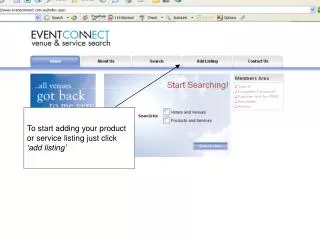
Review: Starting up • Web links to iMapBC: • Maps.bcgov (maps.gov.bc.ca) • Lrdw.ca (lrdw.bcgov) • Nric.ca GIS Self-Serve Tools: iMapBC 2
Review: Logging in Members of the public have access to iMapBC – but logging in as a gov’t employee gives you access to more data Logon using your IDIR user id and password (same as your login in the morning) GIS Self-Serve Tools: iMapBC 2
Review: The Map Window Function Bar Toolbar Information Panel Map Window Do-It-Yourself Go to: http://srmwww.gov.bc.ca/imf/HelpSystem/steps/general1.html# Status Bar GIS Self-Serve Tools: iMapBC 2
Review: Going Somewhere? Zoom-in / Zoom-out Zoom to a location tool GIS Self-Serve Tools: iMapBC 2
Review: Adding Information Add Layer Tool Each folder holds a set of layers that you can add to your map Clicking on the pancake stack lets you see ‘composite’ layers GIS Self-Serve Tools: iMapBC 2
Review: Regional Data Layers Try the Search to look for specifics. See handout for list of regional data (L_) available on iMapBC. GIS Self-Serve Tools: iMapBC 2
Review: Getting Info about Data When you need more info on the data layers you can click on the name of it if it’s coloured blue. This will popup a metadata record for it. GIS Self-Serve Tools: iMapBC 2
Review: The Tool • To get info on a layer you see on the map: • Click on the “i” tool • Click on “Layers” (Function Bar) • Select the layer you want info on • Click on the map on the shape you are interested in • results will show up in the Information Panel GIS Self-Serve Tools: iMapBC 2
Review: Changing Symbols • To change a symbol: • click on the palette after the layer’s name • Information Panel will show this: • Select the feature you want changed and the colour you want. • 100% transparency makes a polygon “hollow” or “invisible” • You have the option of labeling your features by an item in the attribute table GIS Self-Serve Tools: iMapBC 2
Review: Toolsets • You can choose your Toolset, based on what you want to do. • Default: basic tools • Mark-up: allows you to draw points, lines, polygons, text to your map. You can also download your “acetate” layer (point, line and polygon) to a shapefile. • Analytical: allows you to query, select, filter and import shapefiles • User defined: you can choose your own toolsets (based on the ones offered in iMap) to build your own custom toolset. GIS Self-Serve Tools: iMapBC 2
Optional: Shapefile Uploading • you may receive shapefiles from clients representing their area of interest • You can map these in iMap using the upload shapefile tool available under the Analytical Tool Set (Function Bar - Toolsets) • select the upload shapefile tool and the Information Panel will ask you for the location of the dbf and shp file. • you can also change the title of the layer and it’s symbol colour GIS Self-Serve Tools: iMapBC 2
Optional: Selection Menu and Filtering Layers The Analytical Toolset • when creating land document maps you only want to see your file of interest on the map • Click Toolsets on the function bar and choose the Analytical option • Click on the “Select” tool • as with the i-tool, select the layer of interest with the “select” tool • Click on the Select Menu • choose the option “Select by Attribute” GIS Self-Serve Tools: iMapBC 2
Optional: Filtering Layers (cont.) • you can select by a number of fields. E.g.: • PA_NAME = Cultus Lake Park • Fill in your desired query and hit Submit GIS Self-Serve Tools: iMapBC 2
Optional: Filtering Layers (cont.) • the Information Panel will tell you how many features were selected and what your options are • “Default Report” gives you info about your selection • “Extract to Excel” will put that same info onto an Excel spreadsheet • “Filter Layer” will remove all other shapes from your layer except for the one you selected. Useful when making land document maps • “SOE Report” – creates iMap’s version of a tenure conflict report • “Zoom to Extent” – will move the map to where the selected feature is GIS Self-Serve Tools: iMapBC 2
Making a Map • click on the printer symbol • Information Panel will show this • the result will be a PDF file that you can save, print, or e-mail • template options include • land document template • land referral template • water license plat GIS Self-Serve Tools: iMapBC 2
Saving & Sharing your work Two options to save your work: save and download session All your changes will be saved as a file which you can store anywhere (H: preferred) To reload the session you must start up iMap and use the “Open Session” tool save session All your changes will be saved and accessible via a URL (web address) You can send the web address to someone else and they’ll be able to see what you’ve done in the exact same location as when you hit “save” Session will be saved for a limited time GIS Self-Serve Tools: iMapBC 2
Do-it-Yourself (DIY):map making, session saving • select an area to map • select your desired template (if any) • pick your scale, map title, and any additional info required for your template • save it and share it with someone else • try saving your session as a file, and send it to someone else to open GIS Self-Serve Tools: iMapBC 2
Intro. to iMapBC 2 (Tier 2 Users) • Tier 2 : Simple Analysis • TSAT (Terminal Server Access Tool) • Versatile – build custom layouts, colour theme layers, advanced query and analytical capability • Add warehouse data (corporate) • Add local datasets • page 4-6 of your Tier 2/3 Terminal Server Orientation and Data Management Practices Guide GIS Self-Serve Tools: iMapBC 2
The Tier 2 Environment • Web Servers: • Internal HTTPS:\\DTS.BCGOV • External HTTP://DTS.GOV.BC.CA • Use internal to government network with your same IDIR ID and password • It’s like you have 2 computers connected to one monitor. • Let’s log in to DTS • Check your settings and where you store your data • W:\<Ministry>\<your city>\Work Area\ • Page 7 to 11 of your Tier 2/3 Terminal Server Orientation and Data Management Practices Guide GIS Self-Serve Tools: iMapBC 2
The Tier 2 Environment • Working Effectively on the Terminal Server • W:\<Ministry>\<your city>\Work Area\ • Page 12 to 13 of your Tier 2/3 Terminal Server Orientation and Data Management Practices Guide GIS Self-Serve Tools: iMapBC 2
Finding Spatial Data (Data Mining) • Step 1: Question/ Answer • What’s my goal? • What is the deliverable? • What are the limitations of the source data? • Do I have all source datasets required? • Page 14 of your Tier 2/3 Terminal Server Orientation and Data Management Practices Guide GIS Self-Serve Tools: iMapBC 2
Finding Spatial Data (Data Mining) • Step 2: Find the Data that You Need • Data Search Tools http://srmgww.bcgov/landinfobc/imb/ds/find_data.html • iMapBC • LRDW Status Spreadsheets • ArcInfo Coverage Finder • MSRM GIS Data FTP • Oracle Repository Object Browser (ODWA) • P:\ the original data repository, but remember to check .meta • Page 15-16 of your Tier 2/3 Terminal Server Orientation and Data Management Practices Guide GIS Self-Serve Tools: iMapBC 2
Finding Spatial Data (Data Mining) • Step 2: Find the Data that You Need • Data Search Tools • Try the website http://srmgww.bcgov/landinfobc/imb/ds/find_data.html • Page 15-16 of your Tier 2/3 Terminal Server Orientation and Data Management Practices Guide GIS Self-Serve Tools: iMapBC 2
Corporate Data (LRDWhat?) Easy Access to Seamless Provincial Data – providing a seamless integrated province wide view of land andresource information. No Duplication - eliminating duplicate data across ministries and program areas Assured Currency – ensuring that themost current version of the data/ information is representedand published Consistency of Results – allowing consistent, repeatable analysis from uniformly sourced and maintained data LRDW Unified Security - providing a unified security model for data access . • Land Resource Data Warehouse • “LRDW is an integrated collection of data published from diverse sources structured for efficient access in support of decision making and distribution to a wide range of clients.” • Page 17-18 of your Tier 2/3 Terminal Server Orientation and Data Management Practices Guide GIS Self-Serve Tools: iMapBC 2
Connecting to the LRDW • Database Connections • Page 19-21 of your Tier 2/3 Terminal Server Orientation and Data Management Practices Guide • Let’s try connecting • Tips for using the LRDW • Page 21-22 of your Tier 2/3 Terminal Server Orientation and Data Management Practices Guide GIS Self-Serve Tools: iMapBC 2
Tie it all Together • Logon to Terminal Server and copy local data to the W:\drive so you can use the data on the terminal server. • Use Discovery BC Service to locate data • Use Layer Library to add data • Export a subset of data to you W:\ • Carry out analysis (i.e.. geoprocessing) • Page 23-24 of your Tier 2/3 Terminal Server Orientation and Data Management Practices Guide • Reference: • Appendix A: Using Discovery BC Service (pages 25-28) • Appendix B: Using the Layer Library to Access LRDW (pages 29-33) • Appendix C: Other Sites of Interest & Help Resources (page 34) GIS Self-Serve Tools: iMapBC 2
The TSAT Toolbar TSAT: Terminal Server Access Tool Let’s now look at the TSAT handout. Then let’s give this a try!!! GIS Self-Serve Tools: iMapBC 2