Download

1 / 59
910 likes | 1.66k Views
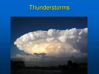
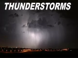
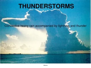
Thunderstorms. TS Facts. It's estimated at any given moment nearly 2,000 thunderstorms are in progress over the Earth's surface. Lightning strikes the earth 100 times each second. There are about 45,000 thunderstorms daily and 16 million annually around the world.

E N D
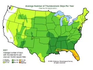
TS Facts • It's estimated at any given moment nearly 2,000 thunderstorms are in progress over the Earth's surface. • Lightning strikes the earth 100 times each second. • There are about 45,000 thunderstorms daily and 16 million annually around the world. • There are at least 100,000 thunderstorms annually across the United States.
TS Facts • In mid-latitudes, thunderstorms are; • most frequent over land in summer. • most frequently of frontal type in winter. • In general movement is in the direction of the 10,000 ft. (700mb) wind.
Conditions for Thunderstorm Development • Conditional instability through a deep layer well above the freezing level. • Adequate supply of moist air from below.
Conditions for Thunderstorm Development • Trigger Action: • Surface heating - convection. • Orographic lifting. • Frontal lifting • Lifting due to convergence in a trough or low. • Differential advection - moist warm air undercutting colder air aloft.
Types of Thunderstorm • Airmass Thunderstorm. • Usually triggered by surface heating such as; • warm sea surface in winter or • hot land surface in summer. • Frontal or Line Type Thunderstorm • Usually occur along the line of the cold front embedded in layer cloud associated with the front.
Types of Thunderstorm • Orographic • forced ascent of air by the high ground rapidly destabilises the air generating convective cells. • Cells are frequently obscured by layer cloud.
Cumulus or Building Phase. • Begins when one or more CU clouds begin to grow into a towering CU. • Typical vertical velocities are frequently in excess of 3000 fpm and can exceed 5000 fpm in severe cases.
Cumulus or Building Phase. • Average life span is 15 to 20 minutes. • No precipitation at this stage due to cell consisting mainly of updraughts.
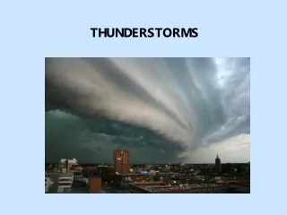
Mature Stage • Mature stage begins with onset of first down-draughts indicated by rain shafts. • Cloud now extends well above the freezing level.
Tops of the cloud are now glaciated (contain mostly ice crystals). • Down draughts associated with increasing volume of precipitation accelerate and produce gust fronts spreading out from the base of the storm.
Mature Stage • Mature stage last about 15 - 20 mins and maximum vertical development is reached.
Dissipating Phase • This is reached when the local supply of moist air is used up. • Anvil top begins to spread out.
Dissipating Phase • Core consists mostly of down-draughts which kill off the up-draughts and rain spreads right across the base of the storm towards the end. • The cloud structure now tends to stratify and spread out.
Dissipating Phase • An individual storm cell may last for less than 1 hour but a system may persist for several hours.
Flight Hazards • Turbulence • Icing • Heavy Rain • Hail • Low Level Windshear • Tornadoes • Lightning • Static Electricity • Instrument Errors
Turbulence • Up/down draughts can vary from 1000 fpm to in excess of 5000 fpm. • Aircraft may experience high rates of roll and pitch and can experience vertical displacements of as much as 5000 feet. • Severe turbulence may be found 15 to 20 miles downwind of severe storm core. • Turbulence by be found up to 5000ft above the tops of CB cells.
Super-cell Thunderstorm Main cause of super-cell thunderstorms is pronounced wind shear with height.
Airframe Icing • Icing range is from 0º C to as low as -45º C • Clear icing may be encountered down to -30ºC. • Inlet anti-ice should always be on prior to any icing encounter, igniters may be needed as well. • Ice ingestion can severely damage axial flow gas turbines. • Piston engines can suffer from induction system icing. • Ice accretion leads to a serious loss of aerodynamic efficiency.
Heavy rain • Ingestion of large quantities of water may cause flameout and possible damage in gas-turbine engines. • Severe updraughts as well as water may induce compressor stalling. • Indicated by loud bangs from the engines. • Igniters should always be on. • Thrust changes should be avoided. • Use approved turbulent air penetration procedures. • Liquid water may exist as low as -30ºC.
Hail • Hail outside of cloud may not show up on weather radar. • No reliable method to predict hail formation. • Severe hail (4") can be encountered up to 10,000 ft. • Damaging hail up to 45,000 ft. • Hail may fall from overhang of anvil into clear air so this zone should be avoided.
Hail • Severe structural damage can result from hail encounters. • No known aircraft accident has yet been attributed to hail.
‘CHIRP’ Feedback Reports • EVENT ONE • Prior to departure Cb's were observed north and west of the field. The SID from RWY 29 calls for a left turn at 2 DME to intercept the XXX VOR (on the field) 166°R until 12 DME, then turn left onto a north-westerly track. The crew believed that this SID would keep them clear of the Cb's and a suitable northbound track could then be requested.
‘CHIRP’ Feedback Reports, cont’d During the left turn after the 2 DME point, ATC gave a radar heading of 250°. The flight then passed through a Cb with intense hail. The noise was so loud they couldn't hear and an ATC instruction to maintain FL 120 on reaching was missed. Both radio altimeters decreased to zero (presumably due to the intensity of the hail) and the GPWS 'PULL UP' terrain warning activated.
‘CHIRP’ Feedback Reports, cont’d The crew responded correctly by increasing attitude and climb rate rapidly and turning left onto heading 210° away from high ground. At FL 120 the aircraft was struck by lightning. During turns, the radar picture may be difficult to interpret. Intense hail doesn't always show red on the radar, which prefers water. It would be helpful if ATC did not vector aircraft into Cb's!
Low Level Windshear • Rapid changes in wind speed and direction. • Microbursts or strong downdraughts can produce catasrophic loss of height during take-off and landing. Microbursts may be wet or dry. • Typical microbursts are less than 5km across lasting 1 - 5 minutes with vertical speeds as high as 60 kt.
Low Level Windshear • Gust front may extend in excess of 20 km from storm centre and up to 6000 ft above the surface. • Cold outflow from down draught may produce wind speed changes as much as 80 kt and direction changes of 90 or more.
Lightning • Can occur within and in clear air adjacent to a thunderstorm. • Most recorded lightning strikes occur between +10ºC and -10ºC (i.e. within 5000 ft above or below the freezing level.) • Strikes may cause serious errors in magnetic compasses and remote magnetic sensors. • They should not be relied upon after a strike and should be checked as soon as possible.
Static Electricity • Seriously affects reception on VLF, MF and HF frequencies. • ADF tends to point to nearest thunderstorm. • Static electricity frequently indicated by a discharge of glowing ionised air particles called St Elmo’s fire. • No effect on VHF and UHF frequencies.
Instrument Errors • Local pressure variations occur in or very close to TS. • Altimeters may be in error by as much as 1000 ft. • Heavy rain may also give false indication on air speed indicators even if pitot heat is on.
Instrument Errors • Air speed indicator may be subjected to violent short term oscillations. • Always maintain a level attitude. • Use turbulent air penetration speed. • A/P Altitude hold should be disengaged and attitude hold engaged.
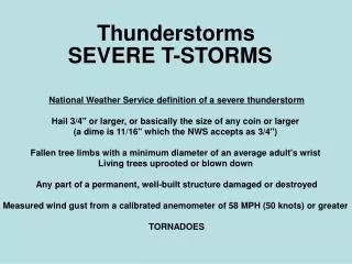
Tornadoes • Threat of tornadoes is always present with severe thunderstorms. • Occur frequently in USA east of Rocky Mts, and in the central plains Mississippi, UK and other parts of the world. • Average ocurrence in UK is about 30 days a year although not as violent as USA. • Vortex may extend right from surface to upper reaches of cloud. • Speed in vortex may exceed 200 kt.
Thunderstorm Avoidance. • Radar returns are attenuated by intervening heavy rain. • Wx radar detects steep rainfall gradients which are the most likely zones for hail. • Areas giving strong radar returns should be avoided. • Larger cells may be concealed behind nearest returns. • Overflying building cells can lead to unexpected encounters due to rapid vertical growth.
Weather Radar Guidance • If visual avoid any cells that by visual inspection are tall, growing rapidly or have anvil tops by at least 10 miles. • In IMC • Up to 25,000 ft avoid echoes by 10 miles. • 25,000 to 30,000 ft avoid echoes by 15 miles. • Above 30,000 ft avoid echoes by 20 miles.