Download
1 / 7
70 likes | 382 Views
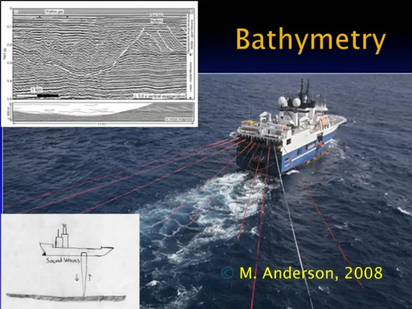
The DNSC08BAT Bathymetry developed from satellite altimetry. Ole B. Andersen and P. Knudsen (DTU-SPACE). DNSC08 Bathymetry. DNSC08 Bathymetry In Google Earth. The DNSC08 Bathymetry. High Quality MSS/Gravity field can be used to map bathymetry.

E N D
The DNSC08BAT Bathymetry developed from satellite altimetry Ole B. Andersen and P. Knudsen (DTU-SPACE)
DNSC08 Bathymetry DNSC08 Bathymetry In Google Earth EGU meeting, Vienna, Austria | April 2008 | OA | page 2
The DNSC08 Bathymetry • High Quality MSS/Gravity field can be used to map bathymetry. • The GEBCO-1 minute is co-registred with DNSC08 used to derive bathymetry • Using Spectral sepration throught filtering (20 and 120 km) • Adjusting wavelength 20 km – 120 km based on DNSC08 gravity optimizing coherency (outside these bands GEBCO-1 is used) • Adjusting depth where GEBCO-1 > 100 meters. • Principle of using • Gravity to predict Bathymetry • (From Sandwell/Smith) EGU meeting, Vienna, Austria | April 2008 | OA | page 3
GEBCO-1 Global Bathymetry EGU meeting, Vienna, Austria | April 2008 | OA | page 4
Difference with GEBCO-1 Global Bathymetry EGU meeting, Vienna, Austria | April 2008 | OA | page 5
Comparison with Polar Stern Bathymetry Survey example around Antarctica EGU meeting, Vienna, Austria | April 2008 | OA | page 6
Summary • DNSC08 Bathymetry • Resolution: 1 minute by 1 minute (2 km by 2 km) • True global fields (90°S to 90°N) • DNSC08BAT ftp.spacecenter.dk/pub/BATHYMETRY • DNSC08 All files ftp.spacecenter.dk/pub/DNSC08 • DVD: Contact oa@space.dtu.dk • Consistent Products available: • Altimetric (geometrical) MSS DNSC08-MSS • Altimetric derived Bathymetry DNSC08-BAT • Altimetryc derived MDT DNSC08-MDT • Altimetric Marine Gravity field DNSC08-GRA • Products also available in Google Earth EGU meeting, Vienna, Austria | April 2008 | OA | page 7