Download
1 / 20
200 likes | 303 Views
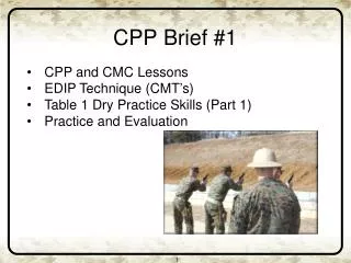
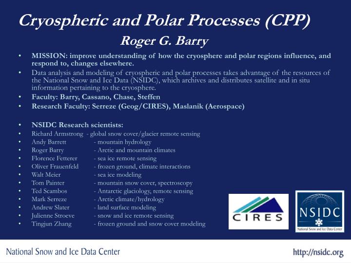
Cryospheric and Polar Processes (CPP) Roger G. Barry. MISSION: improve understanding of how the cryosphere and polar regions influence, and respond to, changes elsewhere.

E N D
Cryospheric and Polar Processes (CPP)Roger G. Barry • MISSION: improve understanding of how the cryosphere and polar regions influence, and respond to, changes elsewhere. • Data analysis and modeling of cryospheric and polar processes takes advantage of the resources of the National Snow and Ice Data (NSIDC), which archives and distributes satellite and in situ information pertaining to the cryosphere. • Faculty: Barry, Cassano, Chase, Steffen • Research Faculty: Serreze (Geog/CIRES), Maslanik (Aerospace) • NSIDC Research scientists: • Richard Armstrong - global snow cover/glacier remote sensing • Andy Barrett - mountain hydrology • Roger Barry - Arctic and mountain climates • Florence Fetterer - sea ice remote sensing • Oliver Frauenfeld - frozen ground, climate interactions • Walt Meier - sea ice modeling • Tom Painter - mountain snow cover, spectroscopy • Ted Scambos - Antarctic glaciology, remote sensing • Mark Serreze - Arctic climate/hydrology • Andrew Slater - land surface modeling • Julienne Stroeve - snow and ice remote sensing • Tingjun Zhang - frozen ground and snow cover modeling
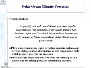
Current foci: • Changes in the cryosphere – Arctic sea ice, Greenland ice sheet, mountain glaciers, Antarctic ice shelves, permafrost • Heat and water balances of the Arctic • Data assimilation • Model parameterizations • Emerging area: • Impacts on and responses of indigenous peoples • IPY Science and data management
Arctic September Average Sea Ice Extent Arctic September Sea Ice Extent/Area Anomaly 2002 - 2005 Arctic Sea Ice Decline - W. Meier, J. Stroeve, F. Fetterer • 2005 lowest September on record • 2002-2005 Septembers all well below normal • September trend is -8%/decade • Different circulation conditions during the four years • Only common factor is higher than normal temps, especially during spring
- Koni Steffen Russell Huff and Konrad Steffen, CIRES/CU
Greenland Ice Flow: Rapid Response to Climate Change • Melt water rapidly migrates to the ice sheet base and enhances basal sliding. • Increasing summer temperatures, more melt water, and greater ice acceleration.
Glaciers at NSIDC • World Glacier Inventory (more than 67,000 glaciers) • 1,000 On-Line Glacier Photographs, 1880-1975 Global Land Ice Measurements from Space (GLIMS): using high resolution satellite data to explore 160,000 glaciers 1928 Retreat of the South Cascade Glacier in the Washington Cascade Mountains, photographed in 1928 and 2000. 2000
Tatiana Khromova Eastern Pamirs 1943 1970 1978 1990 2001 Area decreasing 1943-2001 - 25% 1978-2001 - 19% 1990-2001 - 12% Khromova, T.E.,Osipova,G.B., Tsvetkov, D.G. Dyurgerov, M.D. and Barry, R.G Supported through NASA Grant NNG04GM09G for the GLIMS Core Functions
Larsen Ice Shelf Collapses NASA’s Terra MODIS visible imagery analysis by NSIDC Scientists
Automated Met-Ice-Geo Observing Station (AMIGOS) - Ted Scambos Field team: Ted Scambos Pedro Skvarca Jonathan Thom Ronald Ross Robert Bauer Juan Carlos 60 by 40 km Objectives of the study: • Rate of surface densification? • Rate of basal melting? • Weather/tidal/wind events assoc. with calvings? • Melt ponds? Drainage? Rapid fine-scale calvings? A22A iceberg Thick (~350 meters) Measurements: • Digital Camera @ 6m w/ Iridium trans. • ‘Ping’ radio-echo-sounder (Humphrey) • Flag line for topographic profile • GPS and GPR survey of berg Former Flow Direction site Thin (~80m) Thick (~330 meters) site
Arctic Climate Change Collaboration with NCAR Permafrost extent and active layer depth in CCSM3.0 What is the future of permafrost? Near-Surface Permafrost Area Cold Regions Hydrology NCAR CCSM Andrew Slater - CIRES/NSIDC (Isolated) (Sporadic) (Discontinuous) (Continuous)
Interpolated SWE Mean & Std. Dev Model Truth Raw Assimilated Cold Regions Hydrology – Hydrologic Forecasting Andrew Slater - CIRES/NSIDC • Collaboration with NOAA/NWS • Ensemble Kalman Filter data assimilation of snow for Western US forecasting • Example – Fremont Pass 09/95 – 06/96
0.50 0.25 0 -0.25 -0.50 1930 1936 1942 1948 1954 1960 1966 1972 1978 1984 1990 Freeze Depth Trends – Russia - Tingjun Zhang, Oliver Frauenfeld 1930–1990 net change: -0.27 m 1956–1990 net change: -0.34 m Maximum Annual Depth Departure (m) Source: Frauenfeld, O. W., T. Zhang, R. G. Barry, and D. Gilichinsky, 2004: Interdecadal Changes in Seasonal Freeze and Thaw Depths in Russia. J. Geophys. Res., 109, D05101, doi:10.1029/2003JD004245.
Atmospheric Heat Fluxes Across 70º N - Mark Serreze Latent Heat Flux Moist Static Energy Flux ERA-40 NCEP
Synoptic Forcing of the Arctic Hydrologic Cycle - John Cassano • Create an objective Arctic synoptic climatology based on IPCC GCM simulations • Determine changes in predicted frequency of synoptic patterns during the 21st century • Assess the contribution to Arctic rivers of basin-averaged P-E for each synoptic pattern • Attribute changes in basin average P-E over the 21st century to changes in synoptic patterns and to thermodynamic changes (warming) • Results to date from IPPC simulations indicate: • a decrease of Arctic high pressure patterns • an increase in North Atlantic storm track patterns • These changes correspond to: • warm anomalies in Eurasia and western North America • Increased precipitation along the east coast of Greenland, Scandinavia, and the NW coast of North America
Effect of new land surface parameters on JJA modeled broadband surface albedo in the Community Land Model (CLM 3.0). - Tom Chase Community Climate System Model (CCSM 3.0) sensitivity experiments are compared to MODIS broadband albedo. (a) existing CLM 3.0 parameters (b) new parameters The new parameters have soil colors calculated from 2001 – 2003 MODIS satellite derived surface albedo and lower leaf optical reflectance for grasses than in CLM 3.0. There are large reductions in albedo over Africa and Asia with the new parameters.
What’s at the National Snow and Ice Data Center? SCIENCE DATA and SCIENCE Data management for both Space- and Surface-based data • More than 400 data and information products, most on-line, almost all free • Scientists engaged in data products development • Programmers, systems engineers, writers, and experts in data preservation • Support for data users Proudly sponsored by:
Daily Snow Cover and Sea Ice Extent over North America from DMSP SSM/I Passive Microwave linked to Google Earth Near real time data http://nsidc.org/data/nise1.html
Snow Climate Data Records - Richard Armstrong Consistent data sets can reveal trends Northern Hemisphere Snow Extent 1979 – 2003, from Visible (NOAA) and Passive Microwave (SMMR & SSM/I) Data analysis shows Northern Hemisphere snow extent is decreasing ~ 2% per decade (not statistically significant)
NSIDC leading IPY data management - Mark Parsons • Mark Parsons co-chairing IPY Data Policy and Management Subcommittee • Parsons leading IPY Data and Information Service (DIS) coordination effort • Parsons and Barry hosted IPY data management workshop in Cambridge, March 2006 • Parsons and Barry received NASA award to develop a web services approach to arctic coastal data management in support of IPY • Continuing to seek funding for IPY data management and education.
The NSIDC User Services Offices: Supporting Cryospheric & Earth Sciences David Korn, Amanda Leon, Molly McAllister, Donna Scott, Betsy Sheffield • Expert and timely assistance in selecting and obtaining data • Broad expertise in remote sensing, data manipulation and programming, data management, outreach, and customer service • Assurance of thorough data set documentation and support of data specific tools • Recognized by external reviewers as having the highest customer service satisfaction rating in the federal government.