Seasonal Impacts of Kuroshio Extension Front on Clouds and Sea Fog Dynamics
This study investigates the seasonal effects of the Kuroshio Extension (KE) front on cloud formation and sea fog occurrence. It highlights the contrasting behaviors of these phenomena during winter and summer, shaped by air-sea temperature differences and surface heat flux. In summer, southerly warm advection causes frequent sea fog on the northern flank of the KE front, whereas in winter, turbulent heat release enhances cloud formation on the southern flank. The research suggests that a sea level pressure mechanism drives significant surface wind convergence, impacting cloud depth.

Seasonal Impacts of Kuroshio Extension Front on Clouds and Sea Fog Dynamics
E N D
Presentation Transcript
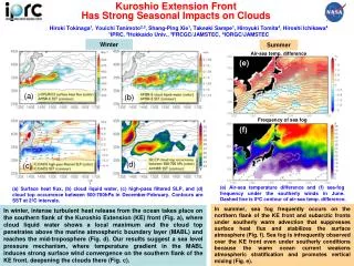
Kuroshio Extension Front Has Strong Seasonal Impacts on Clouds Hiroki Tokinaga1, Youichi Tanimoto2,3, Shang-Ping Xie1, Takeaki Sampe1, Hiroyuki Tomita4, Hiroshi Ichikawa4 1IPRC, 2Hokkaido Univ., 3FRCGC/JAMSTEC, 4IORGC/JAMSTEC Winter Summer Air-sea temp. difference (e) (a) (b) Frequency of sea fog (f) (d) (c) (e) Air-sea temperature difference and (f) sea-fog frequency under the southerly winds in June. Dashed line is 0ºC contour of air-sea temp. difference. (a) Surface heat flux, (b) cloud liquid water, (c) high-pass filtered SLP, and (d) cloud top occurrence between 500-700hPa in December-February. Contours are SST at 2ºC intervals. In summer, sea fog frequently occurs on the northern flank of the KE front and subarctic fronts under southerly warm advection that suppresses surface heat flux and stabilizes the surface atmosphere (Fig. f). Sea fog is infrequently observed over the KE front even under southerly conditions because the warm ocean current weakens atmospheric stratification and promotes vertical mixing (Fig. e). In winter, intense turbulent heat release from the ocean takes place on the southern flank of the Kuroshio Extension (KE) front (Fig. a), where cloud liquid water shows a local maximum and the cloud top penetrates above the marine atmospheric boundary layer (MABL) and reaches the mid-troposphere (Fig. d). Our results suggest a sea level pressure mechanism, where temperature gradient in the MABL induces strong surface wind convergence on the southern flank of the KE front, deepening the clouds there (Fig. c).