
Creepmeters and Borehole Strain Measurement Technologies in Seismic Monitoring
This overview details Advancements in creepmeters utilizing LVDTs as displacement sensors and borehole strain measurement techniques. Focused on legacy instruments, it highlights the deployment of Invar wires for distance change measurements between piers and modern designs by R. Bilham across various locations, including the SF Bay Area and Parkfield. The use of dilatometers and GTSM strainmeters is discussed, emphasizing their roles in monitoring deformations. Current operational frameworks, data archiving, and future maintenance plans for strainmeters in California are examined.

Creepmeters and Borehole Strain Measurement Technologies in Seismic Monitoring
E N D
Presentation Transcript
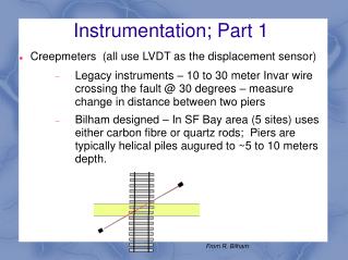
Instrumentation; Part 1 • Creepmeters (all use LVDT as the displacement sensor) • Legacy instruments – 10 to 30 meter Invar wire crossing the fault @ 30 degrees – measure change in distance between two piers • Bilham designed – In SF Bay area (5 sites) uses either carbon fibre or quartz rods; Piers are typically helical piles augured to ~5 to 10 meters depth. From R. Bilham
Instrumentation; Part 2Borehole strain • Dilatometers (first installed in 1980s @ Parkfield); uses lvdt to measure volume change of fluid filled chamber that is ~2 meters long • 5 – Parkfield • 5 – SF Bay • 2 – S. Calif • 4 – Long Valley • GTSM (Legacy or prototype PBO strainmeters) Uses capacitor transducers to measure length change of 4 extensometers – length of each extensometer is ~ few cm; averaging area in borehole a few cm. • 1 – SF Bay • 1 – San Juan Bautista • 1 – S. Calif (???) • 2 – Parkfield – failed • Mini-PBO, 3-component strainmeters; uses 3 vertical chambers each spanning a 120 deg. sector. Otherwise similar to dilatometer • 5 – SF Bay (one not functioning as we are still waiting with UCB to have AC power restored
Instrumentation; Part 2Borehole strain – continued • Simultaneous retirement of personnel from borehole strainmeter project one year ago! • Deformation project in Menlo Park only retained partial expertise
USGS Strain and Creepweb urls: • Locations, data plots and data archive: • http://earthquake.usgs.gov/monitoring/deformation/data/ • http://earthquake.usgs.gov/monitoring/deformation/data/plots/ Low resolution in strain – but does show site locations • http://earthquake.usgs.gov/monitoring/deformation/data/download/ Data archive • High resolution plots of strain data; http://escweb.wr.usgs.gov/share/langbein/Web/USGS_strain/
Locations S.F. Bay San Juan Bautista
Locations Parkfield Southern Calif.
Operations, Part 1: • Only funded to continue operations of Bay Area creep and strain. • Working with NCSN and UCB to upgrade their telemetry to accommodate the borehole strain data (which for the 3-component, mini-PBO includes tilt and pore pressure). Data come in as mini-seed at 100 to 200 sps; raw data available at NCEDC; clean data available at USGS • Once complete, we would remove the low-sample rate, satellite telemetry from these sites. • NCSN and UCB would maintain telemetry (along with co-located seismic equipment) • There is a proposal to upgrade the Parkfield strainmeter sites to continuous, high-rate telemetry • No plans to change creep telemetry from low-sample rate telemetry to higher sample rate • Separate from the telemetry, it is not clear about the future of maintenance to strainmeters – assumption is to operate until the 'die'. How do you define death to a strainmeter? Bad battery??? failure of up-hole electronics? Failure downhole? Where is the expertise?
Operations; part 2 • O & M for central Calif. sites (creep and strain) relies upon having a employee located in Parkfield; that individual also takes care of SAFOD related problems. • O & M for Southern Calif; nothing planned.
Processing and Archiving • Both currently done at USGS Menlo Park • Depends upon availability of Langbein • Could this be transferred to UNAVCO?
1-month GPS and borehole straincomparison High-rate GPS Daily sampled GPS Assumes 10KM distance between GPS stations Borehole strain 1-day