Download
1 / 20
200 likes | 331 Views
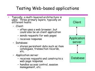
Web Based Device Independent Mobile Map Applications. The m-Chartis System. J. Garofalakis T. Michail A. Plessas. Computer Engineering & Informatics Dept. University of Patras. Computer Technology Institute. Background (1). Mobile devices : mobile phones, smartphones, PDAs, Tablet PCs

E N D
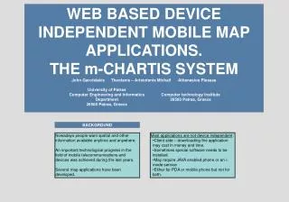
Web Based Device Independent Mobile Map Applications.The m-Chartis System J. Garofalakis T. Michail A. Plessas Computer Engineering & Informatics Dept. University of Patras Computer Technology Institute
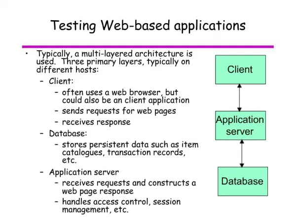
Background (1) • Mobile devices: mobile phones, smartphones, PDAs, Tablet PCs • Recent years: important progress in mobile telecommunications and devices • Users’ requirements: info anytime, anywhere • Result → development of LBS and map applications
Background (2) • Most applications are not device independent: • Client side approach (downloading the application) • Special software needs to be installed • Java enabled or i-mode phones • PDA or mobile, but not both
Constraints of mobile devices • Screen size and resolution • Number of colors, compared to desktop monitors • Limited processing power and storage space • Low data transfer rates and high cost • Not functional interaction with the user • Each limitation is not met in the same extent in all devices
Device independence – our approach • Our approach takes into consideration handhelds’ constraints and capabilities: • Web based approach (simple web pages) • XHTML Mobile Profile pages • No dependence on the connection service (WAP 2.0, i-mode etc) • Pages designed to have the smallest possible size • Possibility to change the size and the zoom level of maps
Device independence – testing the application • In order to confirm that the application is running properly, it was tested with the following devices: • Samsung X460 and D500 (simple phone) • Qtek 8020 (smartphone) • HP iPAQ hw6510 (PDA)
The m-CHARTIS system - overview • Aim: management of information for cities that would be accessible through maps in mobile devices • Two parts: administrator tool and mobile application • Administrator tool: managing information • Mobile application: accessing this information • The system can serve many uses and function as a tourist or professional guide etc
Technical details • PHP and GD library • MySQL • XHTML Mobile Profile • Geographic data in digital file format
Geographic data • Maps produced from the processing of digital spatial data • Digital files with spatial coordinates, not images • MIF (Mapinfo data interchange format) : text files for the description of digital data • Easy processing of data • Scaling and resizing without loss of information and quality
Administrator tool (1) • Secondary web based tool that requires desktop computer • Features: • Insert, delete and modify cities • Insert, delete and modify categories for points of interests. For example museums, restaurants, hotels etc • Insert delete and modify points of interests. For example the archeological museum or the Hilton hotel
Administrator tool (2) • Screenshot: The city’s index page
Mobile application (1) • Specifically designed for mobile devices following special guidelines • Features: • Select one of the available cities • View general information that the administrator has added for each city • Navigate through the map of the city. Navigation starts from pre-specified points. Map scaling and resizing available • Search for points of interest • Search for streets
Mobile application (2) • Screenshot: Navigation page
Mobile application (3) • Screenshot: Searching a point
Map Drawing • A parser reads spatial data from the files and applies the appropriate mathematical transformations to the coordinates • The map is generated with the use of functions of the GD library
Measurements (1) • Usage scenario for bandwidth and time overhead measurements • Script execution time (the overall time depends on the network) • Total KBs received • Use of the application with Samsung X460 (mobile phone), Qtek 8020 (smartphone) and HP PDA
Measurements (2) • Largest page, maximum script execution time: • Mobile phone (128x160) : 7.90 KBs , 0.041 sec • Smartphone (176x220): 13.4 KBs , 0.06 sec • PDA (240x240): 19,3 KBs, 0.07
Conclusions • m-CHARTIS system presentation: a mobile map application • Aim: dissemination of location based information to mobile users • Emphasis on device independence • Exploitation of capabilities of each device for better interaction
Future work • Evaluation and user assessment of the application • Improvements based on the conclusions of the evaluation • Addition of new features such as finding the shortest path from one location of the map to another
End of presentation THANK YOU!!!