Download
1 / 60
600 likes | 727 Views
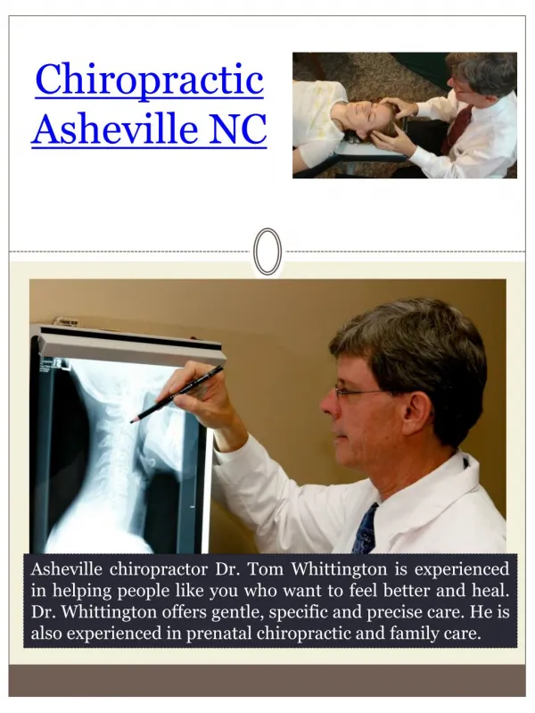
How Open Source Helps Your Projects?. Majed Al-Ghandour, Ph.D., PE, CPM Program Development Branch NCDOT. NCAMPO 2012 Conference Asheville, NC May 2 - 4, 2012. Presentation Outline. What is the Open Source Tour with Open Source Software DynusT

E N D
How Open Source Helps Your Projects? • Majed Al-Ghandour, Ph.D., PE, CPM • Program Development Branch • NCDOT • NCAMPO 2012 Conference • Asheville, NC • May 2 - 4, 2012
Presentation Outline • What is the Open Source • Tour with Open Source Software • DynusT • (Dynamic Urban Systems in Transportation) • WordPress • Closing
Open Source Licenses • My understanding is that “open source” licenses such as GNU GPL3 don’t necessarily require that the software be “free” in terms of not charging for it. • They just require that • (a) the source code always be distributed with the executable, and • (b) that anyone who receives the software cannot make it proprietary. • Check your legal team to provide an open source license.
GNU GPL General Public License Source: http://en.wikipedia.org/wiki/GNU_General_Public_License
Open Source Environment Free Easy to Use Fast Performance
Open Source Environment On your Owen Experience in Coding No Support
E-mail: Mozilla Thunderbird Source: http://www.mozilla.org/en-US/products/thunderbird/
Video Player: Miro Source: http://www.getmiro.com/
GIMP: Graphics / Photo Editing Source: http://gimp-win.sourceforge.net/stable.html
Inkscape: Vector Graphics Application Source: http://inkscape.org/download/
PeaZip: Archiving Source: http://peazip.sourceforge.net/index.html
OpenProjis an open-source desktop project management application similar to Microsoft Project. OpenProjhas a familiar user interface and even opens existing MS Project files. OpenProjis interoperable with Project, Gantt Charts and PERT Charts.
Drupal is an open source content management platform powering millions of websites and applications.
Source: http://www.gcbl.org/blog/marc-lefkowitz/who-collaborate-regional-sustainable-development
Source: http://recoveryfortexas.org/content/texas-transportation-commission-approves-money-public-transportation
SketchUp: Picture anything in 3D Sources: http://picasaweb.google.com/gallery.sketchup/UrbanPlanning#slideshow/5341003808863538946 http://picasaweb.google.com/gallery.sketchup/LandscapeArchitecture#slideshow/5244093690936510850
Atlantica: Pimlico and Arena Districts Source: http://sketchup.google.com/3dwarehouse/details?mid=983a71056cbbc9b29040a7c72f5a18f&prevstart=0
Fusion Tables Gather, visualize and share your data online Source: http://www.google.com/fusiontables/Home/
Source: http://www.ncdot.org/doh/preconstruct/altern/design_build/expressdesignbuild/expressdb.html
Strategic Highway Research Program Some Federal projects such as SHRP2 C10 have required that any software produced be under an open source license. SHRP2 C10 Source: http://www.shrp2c10.org/SHRPC10Portal/Home.aspx
DynusT(Dynamic Urban Systems in Transportation) • Regional Operational Planning Capability • Regional - area larger than corridor • Operational - traffic flow dynamics sensitive to signals, road configurations • Planning - short-term impact and long-term equilibrium • Simulation • Mesoscopic Traffic Simulation • Dynamic Traffic Assignment (DTA) • Micro-meso-micro integration
DTA: Dynamic Traffic Assignment Projects Source: http://code.google.com/p/dta/
Compatibility with Existing Modeling Framework Trip-Based Framework Strategic Modeling Sub-Area Modeling Source: http://www.michigan.gov/documents/mdot/MDOT_DTA_DynusT_Overview_Chiu_8_11_10_334886_7.pdf
Compatibility with Existing Modeling Framework Activity-Based Model Source: http://www.michigan.gov/documents/mdot/MDOT_DTA_DynusT_Overview_Chiu_8_11_10_334886_7.pdf
Triangle, NC Regional DynusT Model Source: http://www.michigan.gov/documents/mdot/MDOT_DTA_DynusT_Overview_Chiu_8_11_10_334886_7.pdf
A Regional View (DynusT Animation) Source: http://dynust.net/wikibin/doku.php?id=start:getting_started
What is Dynamic Traffic Assignment? • A method to predict/estimate how trip-makers may shift to other routes or departure time in response to: • Congestion • Pricing • Controls • Incidents • Improvements • Understand how individual travel decisions impact an entire region, by • Time of day • Origin-Destination (OD) zones • Transportation modes
Macro Meso Micro Proposed toll lanes Analyze Ingress/Egress points for weaving Estimate toll lane usage and revenue Macro-Meso-Micro Integration • Macro • Travel Demand Models (TDM) • Micro • e.g. VISSIM Source: http://dynust.net/wikibin/doku.php?id=start:new_page2
Mesoscopic Traffic Simulation? Source: http://dynust.net/wikibin/doku.php?id=start:new_page2
Other Freeway Operations Scenarios/Strategies • Dynamic message signs • Congestion warning • Mandatory detour • Speed advisory • Information strategies • Pre-trip information • In-vehicle information • Incident • Work zone • Managed lanes • Truck only • Truck restriction
Top left shows a view to traffic simulation. Each vehicles represented by a green dot as it moves through out road networks. Top right shows queues due to the work zone Bottom left shows a view of work zone area allowing to show how vehicles diverse around network work zone area. Bottom right shows speed profiles of the links
Using WordPress Source: http://ahb70.wordpress.com/conferences/2012-conference/