Download
1 / 38
390 likes | 561 Views
Let’s Grow Together!! - A general introduction of Open Source GIS & OSGeo -. 19 th , Sep, 2012 AGF Open Source Session Gaia3D, Inc. Shin, Sanghee(shshin@gaia3d.com). $57.32. $31.92. I-1. What is Open Source SW?. I. Overview of Open Source SW. Freedom Of Software.

E N D
Let’s Grow Together!! - A general introduction of Open Source GIS & OSGeo - 19th, Sep, 2012 AGF Open Source Session Gaia3D, Inc. Shin, Sanghee(shshin@gaia3d.com)
$57.32 $31.92
I-1. What is Open Source SW? I. Overview of Open Source SW Freedom Of Software • Open source SW(OSS) is the computer SW that is available in source code form under certain licenses. • Users of OSS are permitted to use, copy, study, change, improve and even redistribute those OSS freely. • ‘Free’ does not mean ‘Free of Charge’ but ‘Freedom’ Freedom of Redistribute Freedom of Use Freedom of Copy Freedom of Modify
I-2. Cathedral vs. Bazaar I. Overview of Open Source SW • Open Source Software Development Model <Closed Development> <Open Development> Bazaar Cathedral In-House Development Collaborative Development Leverage others knowledge too Leverage own knowledge • Designed and developed by inside R&D lab • Inside knowledge, intellectual property, experiences • Idling knowledge, limited leveraging outside knowledge • Designed and developed with other outside partners • Inside knowledge + outside knowledge • ‘We are smarter than Me!!’ • Leveraging inside & outside knowledge
I-3. Open Source SW vs. Freeware I. Overview of Open Source SW • Open Source SW vs. Freeware OSS Freeware • Users have the right to access &modify the source codes. • In case original programmer disappeared, users & developer group of the S/W usually keep its support to the S/W. • OSS usually has the strong users & developers group that manage and maintain the project • Freeware is usually distributed in a form of binary at ‘Free of Charge’, but does not open source codes itself. • Developer of freeware could abandon development at any time and then final version will be the last version of the freeware. No enhancements will be made by others. • Possibility of changing its licensing policy • OSS is different from Freeware • Antonym of OSS would be ‘Closed Source S/W’ or ‘Proprietary S/W’ • Recently OSS is also regarded as ‘Commercial S/W’
I-4. Benefits of Open Source SW I. Overview of Open Source SW • Benefits of Open Source Software purported by OSS Community • Save money, save resources, increase stability, access to source code, access to skilled community of developers 1. Technological Aspects 2. Economical Aspects 3. Business Aspects 4. Other Aspects Reduce energy Self-Satisfaction Help society Extend company’s products portfolio Open up new market by providing diversified services & products Improve brand image of company Rapid development of high-class SW Increased stability by skilled community review Reduce technological gap to leading proprietary SW company Internalize outside SW developer resources Very low adoption cost Reduce SW development cost Easy to customize Reuse successful story Develop the society by sharing technology & outcomes!!
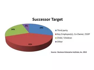
I-4. Benefits of Open Source SW I. Overview of Open Source SW • Open Source Advantages over Commercial SW • Open source’s price tag is clearly important driver. OSS is practically cheaper than commercial one. • 57% said that accessibility to source code really matters and 41% cited community code review as an important benefit over proprietary. • Price &open source code are key factors! * Source : Barracuda Networks
II-1. What is Open Source GIS? II. Open Source GIS • Open Source GIS • FOSS4G : Free Open Source Software for Geo-Spatial • GeoFOSS : GeoSpatial Free Open Source Software
II-2. Why Open Source GIS? II. Open Source GIS • Current State & Needs of Open Source GIS Current State • Boom-up of Open Source &Open Source GIS - Around 300~400 Open Source GIS projects are available (Freegis.org, 2011) • Advance of Open Source GIS - OSGeo Foundation : Commercial proprietary GIS SW can be replaced with Open Source GIS - Google used Open Source based GDAL in its Google Earth program - AutoDeskopend the source code of MapGuide, FDO &MetaCRS and then donated those to OSGeo - ESRI actively used GDAL and also changed its ArcGIS GeoPortal Server to Open Source based one • Active adoption of Open Source GIS in UN, EU, USA , Canada and other countries Necessity • Want to meet lots of needs of GIS from public sectors • Want More with Less!! • Want to replicate other people & institution’s experience • Want to manage & modify the system by ourselves!!
II-3. Characteristics of GIS II. Open Source GIS • Characteristics of GIS • GIS = Vertical Set of Many Software • Interoperability is very crucial among components • Linux, Apache, PHP are Horizontal based Software • GIS is Vertical Architecture based one from DB to web client • GIS as Public Infrastructure = Spatial Data Infrastructure • Vendor neutral, standard based architecture is very important • Active standardization by ISO, OGC • Open Source GIS as another Lego Block • Active implementation of “Standard Compatibility” by Open Source GIS • Open Source GIS could replace commercial proprietary SW/Components
II-4. GIS : Vertical Set of Many Software II. Open Source GIS • Characteristics of GIS : Vertical Set of Many Software Client ArcMAP Google Earth QGIS Web Interface WMS WFS WCS CSW Middleware ArcTMS TMS GeoWebCache Server ArcServer ArcSDE GeoServer MIP DBMS Oracle PostgreSQL Data Map Image DEM
II-5. Another Lego Block II. Open Source GIS ArcReader ArcMap/ArcGIS ArcINFO/ArcGRID ArcPad ArcSDE ArcIMS ArcGIS Server VB, Python uDig, GRASS,gvSIG, QGIS, OSSIM uDig, GRASS,gvSIG, QGIS, OSSIM GRASS, OSSIM, SEXTANTE gvSIG mobile PostGIS Mapserver, GeoServer, DeeGree GRASS, SEXTANTE PHP, Python, Perl, C#.net, etc… Viewing Cartography Analysis Devices Database Web Spatial Server Scripting • Open Source GIS as Substitute for Proprietary Software • Source : Prof. Kwangwoo Nam
III-1. FOSS4G Projects III. Open Source GIS Projects • FOSS4G Projects under OSGeo Umbrella
III-1. FOSS4G Projects III. Open Source GIS Projects • C Tribe TerraLib PostGIS MapGuide GEOS OSSIM GRASS OGR/GDAL Mapserver Proj4 QGIS FDO GMT • Source : Tyler Mitchell
III-1. FOSS4G Projects III. Open Source GIS Projects • Java Tribe gvSIG GeoAPI OpenMap uDig GeoTools GeoServer JUMP JTS Topology Suite DeeGree • Source : Tyler Mitchell
III-1. FOSS4G Projects III. Open Source GIS Projects • .Net Tribe MapWindow Proj4 Proj.Net WorldWind NTS JTS SharpMap GDAL OGR • Source : Tyler Mitchell
III-1. FOSS4G Projects III. Open Source GIS Projects • Web Tribe Ka-Map CartoWeb Mapserver MapBender WMS MapBuilder TileCache OpenLayers FeatureServer PostGIS GeoExt Geoserver MapFish ExtJS OpenScales • Source : Tyler Mitchell
III-2. FOSS4G Based NSDI III. Open Source GIS Projects • FOSS4G Based SDI Architecture
III-2. FOSS4G Based NSDI III. Open Source GIS Projects • FOSS4G Ecosystems Map Window Open Layers GeoExt QGIS Client uDIG World Wind Open Scales Map Fish OWS Interface Middleware Squid TMS GeoWebCache Server MapServer MapGuide GeoServer Deegree GRASS GeoNetwork DBMS PostgreSQL + PostGIS Data Open Street Map Open Aerial Map GeoNames
III-2. FOSS4G Based NSDI III. Open Source GIS Projects • Geo Bolivia • Pursuing Open Source GIS based NSDI
III-2. FOSS4G Based NSDI III. Open Source GIS Projects • EU : INSPIRE • Hybrid model by mixing proprietary and foss4g EU : INSPIRE
III-3. Real Cases III. Open Source GIS Projects • IGN, France http://www.ign.fr • Managing more than 100M spatial entities using PostGIS
III-3. Real Cases III. Open Source GIS Projects • MassGIS, USA http://maps.massgis.state.ma.us/map_ol/moris.php?Yes=Yes • Using PostGIS, GeoServer, GeoExt with ESRI Products
III-3. Real Cases III. Open Source GIS Projects • National Broadband Map, FCCof USA http://www.broadbandmap.gov/ • Using PostGIS, GeoServer, OpenLayers
III-3. Real Cases III. Open Source GIS Projects • TriMet, Portland USA http://trimet.org/ • Using PostGIS, GeoServer, OpenLayers
III-3. Real Cases III. Open Source GIS Projects • Open Source GIS Adoptions in Korea
III-4. Open GeoData III. Open Source GIS Projects • Open Street Map • OSM is made & published by people’s participation!!
IV-1. General Information IV. OSGeo(Open Source GeoSpatial) • OSGeoGeneral • OSGeo • - Open Source Geospatial Foundation • Established in Chicago, US on 4th February, 2006. • Mission : To support the collaborative development of open source geospatial software, and promote its widespread use. • OSGeo is a NPO that is functioning as community of communities.
IV-2. Goal & Activities IV. OSGeo(Open Source GeoSpatial) • Goal & Activities of OSGeo Goal Activities • Provide resources for FOSS4G projects • -Infrastructures • -Legal • -Financial • Promote free and open geospatial data • Create and maintain a quality brand • Create and promote free curriculum • Promote and contribute to standards • Support FOSS4G on a global scale • Support local activities and capacities • Facilitate inter-project communication • Build a solid market for business and users • Interface with industry and academia • Support the education of domain experts not <brand specialists> http://www.osgeo.org
IV-3. Governance Structure IV. OSGeo(Open Source GeoSpatial) • Governance Structure of OSGeo
IV-4. Activity Meter IV. OSGeo(Open Source GeoSpatial) • OSGeo Activity Meter Source : http://lists.osgeo.org
IV-5. Incubation IV. OSGeo(Open Source GeoSpatial) • OSGeo Incubation • Efforts for ensuring high quality open source GIS development • A kind of project health inspection Have a successfully operating open and collaborative development community 1 Have clear IP oversight of the code base of the project 2 Adopt the OSGeo principles and operating principles 3 Are mentored through the incubation process 4
IV-5. Incubation IV. OSGeo(Open Source GeoSpatial) • OSGeoIncubation Projects Statistics
IV-6. OSGeo Live IV. OSGeo(Open Source GeoSpatial) • Enterprise Ready Open Source GIS Stacks
IV-7. Conferences IV. OSGeo(Open Source GeoSpatial) • FOSS4G Conference • Annual largest open source GIS conference hosted by OSGeo • FOSS4G 2013 will be held at Nottingham, UK
V-1. Wrap-up V. Wrap-up Cost Reduction Advance of Open Source GIS Interoperability • Open Source GIS is now comparable with commercial proprietary GIS • Open Source GIS is now actively adopted & used all around the world Opened Source Code • Open Source GIS is basically free. • The price of commercial Open Source GIS is lower than proprietary one • Almost all the Open Source GIS is compliant with OGCstandards • Open Source GIS can be used with existing proprietary GIS Collaboration based SW • Anybody can modify & upgrade the system from the source code level • Can easily replicate or migrate success cases to their system • Collaboration, sharing & community based SW development model • Source code will be managed by community not by company • Neutrality from specific technology or company • Anybody can join and contribute to Open Source GIS with OSGeo
Thank you Q&A