Download
1 / 2
20 likes | 124 Views
Explore key facts about West African countries such as population, major exports, and urbanization percentages. Use maps and labels to identify countries, rivers, and bodies of water in the region. This study guide includes information from pages 533 to 535 of the Purple book.

E N D
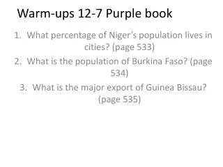
Warm-ups 12-7 Purple book What percentage of Niger’s population lives in cities? (page 533) What is the population of Burkina Faso? (page 534) What is the major export of Guinea Bissau? (page 535)
Map of West Africa use maps on page purple 542-543 or blue 371, 373 • Label each country • Cape Verde • Mauritania • Senegal • Gambia • Guinea Bissau • Guinea • Mali • Sierra Leon • Liberia • Cote D’Ivorie • Ghana • Burkina Faso • Togo • Benin • Niger • Nigeria • Chad • Label the following rivers • Senegal • Gambia • Niger • Volta • Benue • Bodies of water • Lake Chad • Lake Volta • Atlantic Ocean • Gulf Guinea • Color the water blue and color the Sahel countries orange • Color the Coastal countries Green • Color Nigeria purple