
Uploaded by
tynice
2 SLIDES
99 VIEWS
20LIKES
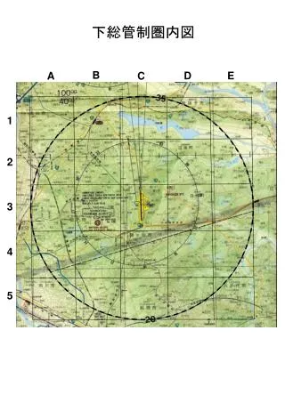
下総管制圏内図
DESCRIPTION
下総管制圏内図. B. D. E. A. C. 1. 2. 3. 4. 5. 飛行経路記入例. 下総管制圏内図. B. D. E. A. C. 1. 2. 3. 4. 5. 経路:5NM東 → 撮影ポイント(3D) → 5nm北東 高度:1,000~2,000ft.
Download
1 / 2
Download Presentation 
下総管制圏内図
An Image/Link below is provided (as is) to download presentation
Download Policy: Content on the Website is provided to you AS IS for your information and personal use and may not be sold / licensed / shared on other websites without getting consent from its author.
Content is provided to you AS IS for your information and personal use only.
Download presentation by click this link.
While downloading, if for some reason you are not able to download a presentation, the publisher may have deleted the file from their server.
During download, if you can't get a presentation, the file might be deleted by the publisher.
E N D
More Related