Chapter 09 Cloud Formation Lesson 27-28-29
380 likes | 1.33k Views
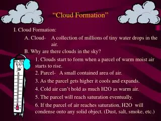
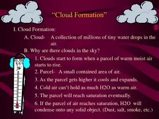
Chapter 09 Cloud Formation Lesson 27-28-29. Cloud Hazards. The principal causes of concern are the following: Visibility reduction Turbulence Airframe icing Precipitation. Cloud Amount. Clouds are reported in OKTAS (1/8ths).

Chapter 09 Cloud Formation Lesson 27-28-29
E N D
Presentation Transcript
Cloud Hazards • The principal causes of concern are the following: • Visibility reduction • Turbulence • Airframe icing • Precipitation
Cloud Amount • Clouds are reported in OKTAS (1/8ths). • To assess the cloud cover the observer divides the sky into 8 equal sections and the cover is assessed according to the number of sections covered by the cloud.
Cloud Base • Is defined as, “ The lowest zone in which the type of obscuration perceptibly changes from that corresponding to clear air or haze to that corresponding to water droplets or ice crystals.” • The height of the cloud base is reported as height above ground level at the reporting station on synoptic charts and in metars.
Cloud Base • On low level significant weather charts the heights of cloud are forecast as height above mean sea level. • On upper level significant weather charts cloud base heights are forecast as flight levels.
Methods of Cloud Formation • Convection • Convergence • Orographic Lifting • Frontal Lifting • Boundary Layer Turbulence
Cloud formed by Boundary Layer Turbulence (STRATUS/STRATOCUMULUS)
Determination of cloud base Level of free convection Dew Pt Surface temperature
Effect of RH on Cloud Base • A decrease in RH will increase the cloud base. • As the day warms up and the spread between dew point and surface temperature increased the the cloud base would rise and • As the day cooled towards night fall the surface temperature would decrease toward the dew point increasing the RH% and the cloud base would drop.
Atmospheric Lifting Convective Lifting • Caused by a warm surface transferring heat to the air in contact with it • Decreases the density of the air • Increases buoyancy • Warm air rises and keeps rising until it has cooled down to the same temperature as its surroundings.
Atmospheric Lifting Convective Lifting, cont’d • Additionally stable air which has been forced to rise will have the ELR modified by the release of latent heat of condensation which can modify the lapse rate and so release latent instability and thus initiate convection. • The point at which this occurs is known as the level of free convection.
Atmospheric Lifting Con’t • Forced Ascent is caused by a number of factors, namely: • Orographic Lifting where air is forced to rise over hills or mountains. • Frontal lifting where air is forced to rise up a frontal surface where two air masses are in contact such as warm fronts, cold fronts and occluded fronts. • Convergence in depressions and troughs.
Convective Cloud Formation Dew Pt Surface heating Critical temperature
Convective Cloud Formation • Requirements: • Adequate supply of moist air at low level. • Conditionally unstable lapse rate at least through a few thousand feet. • Sufficient heating to critical temperature to lift air to the level of free convection • If the conditional instability extends through a deep layer, CB and TS may result if the air is sufficiently moist.
Turbulence Cloud Inversion • Formed by turbulent mixing in the boundary layer ELR Old ELR 4ºC 6ºC 8ºC 2000 ft Top of Boundary Layer Descending air warming at DALR New ELR 3 ºC/1000’ Turbulent Mixing Rising air cooling at DALR 10ºC 14ºC 12ºC
Turbulence Cloud Formation 1000ft HMR line
Turbulence Cloud (cont) • Requirements • Sufficient turbulence to modify lapse rate in friction layer to 3/1000 feet. • Moist air. • Stable ELR.
Turbulence Cloud (cont) • Effects of Mixing: • Formation of inversion at top of mixing layer. • Warming at surface. • Cooling at top of mixing layer. • Drying of air at surface level. • Moistening of air aloft and formation of ST/SC cloud. • Temp at middle of mixing layer is unchanged.
Cloud types and cloud classifications • Clouds generally fall into 3 main types, namely: • Cirroform • Cumiliform • Stratiform
Cloud Chart Nil Turb. Nil Icing. CB/TS Nil/Lt Turb. Lt/Mod Icing. Mod/SevTurb. TCU Mod/Sev Icing. Mod Turb. Mod Ocnl Sev Icing. Lt/Mod Turb. Mod Ocnl Sev Turb. Lt/Mod Icing. CU Nil/Lt Turb. Lt/Mod Icing.
Cloud types and cloud classifications • Cirroform Clouds, are generally high altitude clouds and and have little vertical development and have a fibrous appearance with ill defined edges. They are composed almost exclusively of ice crystals. • Cumiliform clouds, have rounded heaped type appearance or ‘cauliflower’ shape. They often appear brilliant white and have sharp defined edges. They usually have extensive vertical development but limited horizontal extent. • Stratiform Clouds, have wide horizontal extent and limited vertical development and generally opaque and grey in appearance.
Ten Main Cloud Types • High Level Clouds - Cirroform(fibrous) • Cirrus (CI): These are detached clouds in the form of white delicate filaments, or white, or mostly white, patches or narrow bands. They have a fibrous appearance, or a silky sheen or both. • Cirrostratus (CS): These have a transparent, whitish veil of fibrous or smooth appearance, totally or partially covering the sky. They generally produce a halo when the sun or a full moon is above them. • Cirrocumulus (CC): These appear as thin, white patchy, sheet or layer of cloud without shading, composed of very small elements in the form of grains, ripples or bars merged or separate and more or less regularly arranged. Most of the cloud elements have a width of less than 1 degree.
Cloud Types cont’d • Medium Level Clouds - Layer type: • Altocumulus (AC): Appearance is white or grey, or both white and grey patches in sheets or layers. They generally have shading and are composed of laminae, rounded masses, rolls which are sometimes partly fibrous or diffuse and which may or may not be merged. Most are regularly arranged and the elements have an apparent width of between 1 to 5 degrees. • Altostratus(AS). Greyish or bluish cloud sheet or layer of striated, fibrous or uniform appearance, totally or partly covering the sky, and having parts thin enough to reveal the sun at least vaguely, as if through ground glass. Altostratus does not show halo phenomena.
Cloud Types cont’d • Low Level Clouds - Layer type: • Nimbostratus(NS). Grey cloud layer, often dark, the appearance of which is rendered diffuse by more or less continuously falling rain or snow, which in most cases reaches the ground. It is thick enough throughout to blot out the sun. Low ragged clouds frequently occur below the layer, with which they may or may not merge. • Stratocumulus(SC). Grey or whitish, or both grey and whitish, patch, sheet or layer of cloud which almost always has dark parts, composed of tessellations, rounded masses, rolls, etc., which are non-fibrous (except for virgae and which may or may not be merged; most of the regularly arranged small elements have an apparent width of more than five degrees. • Stratus(ST). Generally grey cloud layer with a fairly uniform base, which may give drizzle, ice prisms or snow grains. When the sun is visible through the cloud its outline is clearly discernible. Stratus does not produce halo phenomena except, possibly, at very low temperatures. Sometimes stratus appears in the form of ragged patches.
Cloud Types cont’d • Cumuloform - Heap type (Classified as low cloud) • Cumulus(CU). Detached clouds, generally dense and with sharp outlines, developing vertically in the form of rising mounds, domes or towers, of which the bulging upper part often resembles a cauliflower. The sunlit parts of these clouds are mostly brilliant white; their base is relatively dark and nearly horizontal. Sometimes cumulus is ragged. • Cumulonimbus(CB). Heavy and dense cloud, with a considerable vertical extent, in the form of a mountain or huge towers. At least part of its upper portion is usually smooth, or fibrous or striated (cappilatus), and nearly always flattened: this part often spreads out in the shape of an anvil or vast plume. Under the base of this cloud, which is often very dark, there are frequently low ragged clouds either merged with it or not, and precipitation sometimes in the form of virga.
Cumulus Cloud Formation • These clouds usually have a sharply defined ‘cauliflower’ shaped appearance. • Main method of formation is convective activity due to surface heating. • Usually form when the ELR is conditionally unstable. • Can vary from small fair weather cumulus to towering cumulus and huge CB and TS.
ELR Equilibrium level Condensation level
Large Cumulus Cloud Formation Tropopause SALR ELR DALR DPLR
Orographic Cloud • Requirements for it’s formation are: • Moist air. • Terrain high enough to lift the air to the condensation level. • Stable environmental lapse rate.
Orographic Cloud FREEZING LEVEL 0°C 3°C
FÖHN WIND Warming at DALR Cooling at SALR