1 / 53

Peru, 2013

Peru, 2013. Artesonraju , 6025 m (19,800’). Our goal is the famous peak from the Paramount Pictures logo. Huaraz (base town) Nestled in the low valley at 10,000’. Sunset on the peaks from my hotel balcony. First acclimatization hike up to Lago Churup 14,600’.

trygg
Download Presentation

Peru, 2013

An Image/Link below is provided (as is) to download presentation Download Policy: Content on the Website is provided to you AS IS for your information and personal use and may not be sold / licensed / shared on other websites without getting consent from its author. Content is provided to you AS IS for your information and personal use only. Download presentation by click this link. While downloading, if for some reason you are not able to download a presentation, the publisher may have deleted the file from their server. During download, if you can't get a presentation, the file might be deleted by the publisher.

E N D

Presentation Transcript


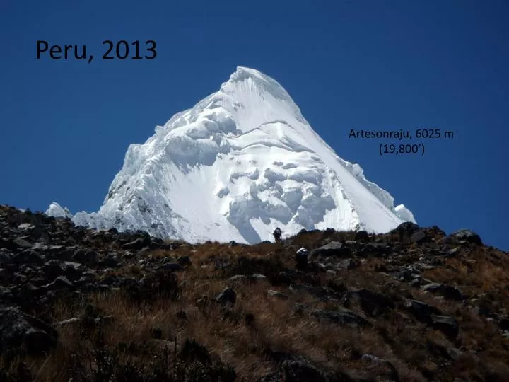
  1. Peru, 2013 Artesonraju, 6025 m (19,800’)

  2. Our goal is the famous peak from the Paramount Pictures logo.

  3. Huaraz (base town) Nestled in the low valley at 10,000’

  4. Sunset on the peaks from my hotel balcony.

  5. First acclimatization hike up to LagoChurup 14,600’

  6. I had the place all to myself.

  7. 2nd acclimatization hike up to LagoLlaco. It was a really bad road up. The other 2 cars we saw broke down. We made it, somehow.

  8. Hiked up to the glacier’s edge at 16,400’

  9. Time to head to the high mountains.

  10. Loading up the 80 lb pack with 7 days of supplies and gear.

  11. First camp was beyond the other side of the LagoParron.

  12. Lake camp. Our goal has come into view.

  13. A steep climb up to Moraine Camp. 15,900’

  14. We passed many memorials to fallen climbers. Not really a good omen.

  15. Weird plants along the way.

  16. John and our cook approaching Moraine Camp. Our route is up the right side.

  17. Pretty views. High camp will be across the low glacier and in the col.

  18. Joaquin cooking us dinner as it starts to snow.

  19. More snow. Not good for our chances of summiting.

  20. We crossed this glacier a few times, preparing our high camp on the other side.

  21. We had to descend a rock slide to even get to the glacier.

  22. Lots of crevasses to negotiate.

  23. On the way to high camp. 5000 m.

  24. Me trying to spot our route in the snow and clouds.

  25. Time to make dinner and melt water for our ascent.

  26. Our route goes up the face on the right. But first we have to cross a jumbled crevasse field, left over from when the glacier on our route ripped free and avalanched to the base.

  27. I hate 1:00 am starts. Cold climbing through the night, weaving through crevasses.

  28. A sketchy snow bridge to cross on the way. But it was our only option.

  29. First light and we are just to the base of the steep face. Camp is at the bottom, somewhere.

  30. Arduous climbing, The fresh snow is knee deep and doesn’t afford a lot of good protection.

  31. Starting to feel the toes again.

  32. Crossing the bergschrund at the base of the face.

  33. Up through a sketchy rock band.

  34. up

  35. And up

  36. And up

  37. And up

  38. And up

  39. The weather deteriorates when we are about at the arrow. We decide to head down. 250 m shy of the summit. It’s a bummer because I was feeling strong.

  40. It’s snowing hard and waterfalling down the entire face above us. It buries us and our anchors in seconds.

  41. We make eight 70 meter rappels to get back to the bergschrund.

  42. Final rappel over the berg. We were just up there in the clouds somewhere.

  43. A steep harrowing descent down a debris slide.

  44. Unstable ice

  45. John leading the descent. Our tents are the two dots way down below.

  46. Back down to Moraine Camp. The view from my tent.

  47. John filtering our snow samples. Science!

  48. The steep hike down to the turquoise lakes.

More Related