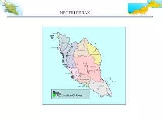
NEGERI PERAK
100 likes | 433 Views
NEGERI PERAK. Note : AIZ Location Of Area. Tasik Temenggor. Sg.Dala , Hulu Perak. Tasik Kenering. Rungkup Hilir. TASIK TEMENGGOR, HULU PERAK. Tasik Temenggor. Fig 1.2 : View of the potential area that had been developed. Fig 1.3 : View of site area

NEGERI PERAK
E N D
Presentation Transcript
NEGERI PERAK Note : AIZ Location Of Area
Tasik Temenggor Sg.Dala , Hulu Perak Tasik Kenering Rungkup Hilir
TASIK TEMENGGOR, HULU PERAK Tasik Temenggor Fig 1.2 : View of the potential area that had been developed Fig 1.3 : View of site area from the North point Fig 1.4 : View of water body at site area Fig 1.1 : Locatioan map
TASIK KENERING, HULU PERAK Tasek Kenering Tasik Kenering Fig 1.2 : View of the potential area that had been developed Fig 1.3 : View of Perak river at the site area Fig 1.4 : View of water body at site area Fig 1.1 : Locatioan map
RUNGKUP HILIR, HILIR PERAK Fig 1.2 : View of the potential area that had been developed Fig 1.3 : View of site area from the North point Rungkup Hilir Fig 1.4 : View of water body at site area Fig 1.1 : Locatioan map
Sg.Dala, HULU PERAK Fig 1.2 : View of the potential area that had been developed Fig 1.3 : View of site area from the North point Sg.Dala, Hulu Perak Tasek Kenering Fig 1.4 : View of water body at site area Fig 1.1 : Locatioan map