Download
1 / 11
110 likes | 280 Views
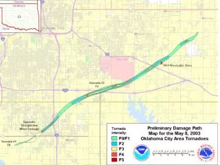
x. 3904 Woodcutter Drive. 3904 SE Woodcutter Drive. I-40. Westminster Road. Path of Tornado. Westminster Road. I-40. Path of Tornado. 11331 Burning Oaks Road (looking left from the end of Woodcutter Dr). Burning Oaks Road (looking right from the end of Woodcutter Dr).

E N D
x 3904 Woodcutter Drive
3904 SE Woodcutter Drive I-40 Westminster Road Path of Tornado
Westminster Road I-40 Path of Tornado
11331 Burning Oaks Road (looking left from the end of Woodcutter Dr)
Burning Oaks Road (looking right from the end of Woodcutter Dr)
Fast Facts about the May 8, 2003 Oklahoma City Tornado • (From National Weather Service website) • The tornado was first reported by a spotter on the west side of I-35 at Hwy. 37 in Moore, near the intersection of Santa Fe Ave. and 149th St. at about 5:10 p.m. It then tracked across I-35 at 12th St., through south Oklahoma City, across I-240 at Sooner Road, across Tinker Air Force Base, across I-40 into SE Midwest City, and into Choctaw.Approximately 21 minute lead time for Moore in Cleveland County and approximately 30 minute lead time for Oklahoma County.Preliminary estimates indicate the tornado path was about 19 miles long.The tornado outbreak was forecast several days in advance.For the first time ever at the NWS Norman office, a live weather briefing was given at 2:30 pm CDT on 5/8/2003 concerning the developing severe weather situation. This briefing was broadcast through the 10 weather radio stations operated by NWS Norman.The first tornado warning of the day was for Grady County at 4:33 p.m.The warning issued for the metro area, including Cleveland, McClain and south Oklahoma Counties was issued at 4:49 p.m.The NWS Forecast Office issued a regional weather discussion at 4 p.m. that specifically mentioned the risk for severe storms in the Oklahoma City metro area between 4:30 and 6 p.m.The NOAA/NWS Storm Prediction Center issued a tornado watch for south central Kansas and central Oklahoma, including the Oklahoma City metro area, at 1:35 p.m.Staff members from the National Weather Service Norman Forecast Office are conducting surveys of the damage. An F-scale rating will be released when the surveys are completed, possibly as soon as Friday afternoon.Preliminary total tornadoes in central Oklahoma - 3.About the time the metro area tornado was dissipating, a new tornado started near Harrah and moved into southern Lincoln County north of Meeker.An additional tornado occurred in Noble County.While the tornado was on the ground, the NWS FO provided continuous live coverage of the storm track on NOAA Weather Radio.