Download
1 / 28
280 likes | 301 Views
This presentation discusses the use of short range ensemble forecasts in the National Fire Weather Outlooks. It includes case studies and the benefits of using ensemble forecasts over single deterministic models.

E N D
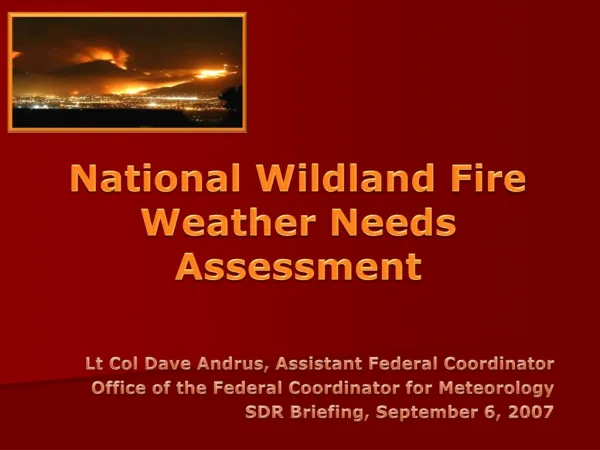
Using Short Range Ensemble Model Data in National Fire Weather Outlooks Sarah J. Taylor David Bright, Greg Carbin, Phillip Bothwell NWS/Storm Prediction Center Richard Naden Southwest Predictive Services
Overview • SPC Fire Weather Program • Use of short range ensemble forecasts (SREF) • Case Studies • July 8, 2003 • Recent Santa Ana event (October 25-31, 2003) • Conclusions
SPC Fire Weather Program • Fire weather forecasts began in 1998 • Purpose is to provide national fire weather guidance to NWS, federal, state and local government agencies • Product will outlook areas where critical fire weather conditions combined with pre-existing fuel conditions forecast to occur
SPC Fire Weather ProgramTypes of Outlooks: • Critical Fire Weather Areas • Extremely Critical Fire Weather Areas • Dry Thunderstorm Areas • Issued for widespread dry lightning
Critical Fire Weather Area • Outlooks based on forecasts of Relative Humidity, maximum temperatures, sustained winds, and pre-existing fuels • RH criteria varies by geography • Temperatures must be greater than 60 F • Sustained surface winds (10 meter) must be greater than 20 mph • High Fire Danger Class Index, low 100/1000 hr fuel moisture, long term drought
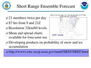
Use of SREF output • What is an ensemble forecast?? • Collection of different model solutions • By changing the initial conditions, different forecast solutions are created • SPC uses a 15 member ensemble from NCEP • Consists of Eta, Eta KF, RSM models • 48 km resolution
Use of SREF output • Ensemble forecasts first applied operationally in the 1990s • Studies have shown that ensembles are more skillful than using 1 single model (Wandishin et al, 2001, Bright and Mullen 2001) • SPC began using SREF operationally in 2002
Use of SREF output • At the SPC, nearly 300 SREF products are available: • Relative Humidity • Temperature • Wind • Fosberg Fire Weather Index • Haines Index • Convective precipitation • Combinations of the above
Use of SREF outputStatistical Fields • Mean and Spread • Shows the “average” of the ensemble • Will smooth small scale features • Probability • Indicate the percentage of ensemble members which meet certain criteria • Extreme values • Useful in predicting “worst case” events
Fosberg Fire Weather Index Mean and Standard Deviation Valid July 8 at 2100 UTC
Probability of Fosberg FWI greater than 75 Probability of Fosberg FWI greater than 50
Maximum Fosberg Fire Weather Index valid 18 UTC July 8, 2003
Case Studies/Verification • SPC Fosberg Fire Weather Index is used to verify fire weather outlooks • Index is calculated with local objective analysis scheme • Fosberg FWI greater than 50 is a “threshold” value
Case Studies (July 8, 2003) • Forecast valid at 18 UTC on July 8 • Minimum RH with Mean Surface Wind Sustained winds 20 kts or greater Minimum RH less than 5%
Santa Ana Event October 2003 • Statewide loss of 20 lives • 2600 houses with over 725,000 acres burned • Monetary loss figures for the disaster are estimated to be over two billion dollars
2055 UTC October 27, 2003 Image courtesy of Liam Gumley, Space Science and Engineering Center, UW-Madison
Santa Ana Event October 2003 • SREF showed some skill • Increased resolution of model would likely create better forecasts • Fosberg Fire Weather Index did not verify well for this event
Conclusions • Short range ensemble forecasts will be used more and more in the future • With increased experience and development, ensembles will likely prove to be more useful than a single deterministic model
Conclusions (Continued) • Model resolution increases • Better model physics • Ongoing research in Initial Condition perturbations • Increased ensemble spread • Data mining tools and display
Acknowledgements • The authors would like to thank Steve Weiss at the Storm Prediction Center for his review and Jason Levit for his assistance with case study data
For more information • Visit the SPC Fire Weather Page: • www.spc.noaa.gov/fire • Page contains latest SPC fire outlooks, Eta forecasts and latest surface analysis • Will include ensemble forecast guidance in the future • This presentation is available online: www.spc.noaa.gov/publications/taylor/srefams.html Email: Sarah.Taylor@noaa.gov