Download
1 / 21
210 likes | 344 Views
Global Terrestrial Network HYDROLOGY (GTN-H). Supported by: World Meteorological Organization/Climate and Water Department (WMO/CLW) Global Climate Observing System (GCOS) Global Terrestrial Observing System (GTOS) Observational arm of the GEO/IGWCO Theme. Goals of GTN-H.

E N D
Global Terrestrial NetworkHYDROLOGY (GTN-H) • Supported by:World Meteorological Organization/Climate and Water Department (WMO/CLW)Global Climate Observing System (GCOS)Global Terrestrial Observing System (GTOS)Observational arm of the GEO/IGWCO Theme
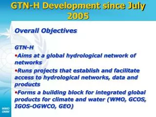
Goals of GTN-H • Aims at creating a global hydrological network of networks • Plans and implements projects that facilitate access to hydrological networks and observation data, and generates derived products • Forms an essential component for integrated global and regional hydrological products
Main Objectives • Make available data from existing global hydrological observation networks and enhance their value through integration • Generation of datasets suitable for: • Research in the areas of global and regional climate change • Environmental monitoring, and • Hydrology and water resource management
Selected Achievements • Prototype system for the online near-real time data access to over 400 river gauging stations worldwide • Access to a first global gridded precipitation product • First-time online access to a global water quality database • Prototype definition of a hydrological metadata standard, based on the WMO core metadata standard
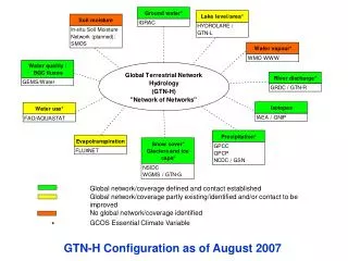
Configuration (as of October 2008) GTN-H Secretariat, October 2008
GTN-H Projects Status October 2008
Products that enhance baseline or core hydrological data and improve our knowledge of hydrology • Development of gridded runoff datasets (B. Fekete/UNH) • Ready to distribute gridded runoff and discharge products • Significant progress on: • core gridded river networks at various resolutions • co-registration of auxiliary data discharge gauges, lakes/reservoirs, etc. • streamlining the access to climate forcing information • Map product on real-time hydrological data acquistion (I. Dornblut/GRDC) • Prototype of a scaleable and interactive map is provided by GRDC • Development of software till end of 2008
Products that are designed to address specific science questions • Reference Hydrological Datasets – pristine basins (H. Lins, U. Looser, W. Grabs) • Letter from WMO in 2006, 23 countries have replied positively, 22 provided a list of river discharge stations • Data are essential for calibration and validation of remote sensing data and climate models, as well as monitoring of trends and changes in the water system • GTN-H Networks (S. Bojinski) • Setting of criteria for defining each of the GTN-H variables and networks – successfully completed
Where do we go from here? • Integration with WMO Integrated Global Observing Systems (WIGOS) • Definition of GTN-Hs role as the observational arm of GEO/IGWCO • Development of map-server aggregated data products • Implementation of HARON with GTN-H as a core partner
RECOMMENDATIONS Seek support by GCOS SC through: Expressing support to continued collaboration between GCOS and the WMO CLW/Hydrology secretariats in advancing the GTN-H and its emerging networks Stressing the importance of global hydrological networks, including appropriate data exchange and means of telecommunication Reiterating the strong concern over the continuing decline of hydrological networks, especially the closure of climate-relevant stations Calling upon WMO CHy to assign highest priority to address these issues and take appropriate remedial action
International Context Joint effort of the: • World Meteorological Organization/Climate and Water Department (WMO/CLW) • Global Climate Observing System (GCOS) • Global Terrestrial Observing System (GTOS) • Observational arm of the Group on Earth Observations/ Integrated Global Water Cycle Observations Theme (GEO/IGWCO)
National Snow and Ice Data Centre (NSIDC) Daily snow extent and snow water equivalent derived from NASA EOS AMSR-E (passive microwave) and MODIS (optical) Satellite Date (26 Feb – 5 March 2003)
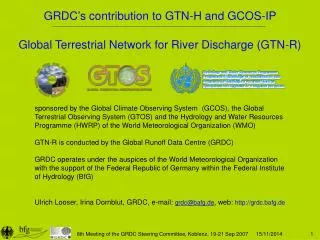
Global Terrestrial Network for River Discharge (GTN-R) • Global Runoff Data Centre (GRDC) hosts data of over 7000 river gauge stations from 156 countries • Subset of 400 river discharge refernence stations: GTN-R as a priority network along the continental coastlines, covering about 70 per cent of total continental runoff • http://gtn-r.bafg.de
Global Terrestrial Network for River Discharge (GTN-R) 400 river discharge reference stations worldwide, covering about 70 per cent of total continental coastline
Global Terrestrial Network for Lakes (GTN-L) • International Data Centre on the Hydrology of Lakes and Reservoirs (HYDROLARE) • established in 2007 • Develop and regularly update an international database on the hydrological regime of lakes and reservoirs (including metadata) • Monitoring 150 major lakes and reservoirs worldwide
Global Precipitation Climatology Centre (GPCC) • Provides raingauge-based monthly precipitation analyses, for monitoring and research of the Earth’s climate • Largest in situ precipitation database worldwide • 78 000 stations in more than 180 countries • http://gpcc.dwd.de
Global Precipitation Climatology Centre (GPCC) Precipitation anomaly for January – December 2007 in millimeters per month as a departure from the 1961-1990 base period
European Space Agency (ESA) • Soil Moisture and Ocean Salinity (SMOS) mission • http://www.esa.int International Atomic Energy Agency (IAEA) • Global Network of Isotopes in Precipitation (GNIP) • http://www.iaea.org/water
Hydrological Applications and Run-Off Network (HARON) Background River discharge has a role in influencing the climate system, as the freshwater inflow to the oceans alters the thermohaline circulation, acts as an indicator for climate variability and change as they reflect changes in precipitation and evapotranspiration, and is also required for the calibration of global models, trend analysis and socio-economic investigations. Goal, Objective and Outcome • goal is to observe and analyze surface runoff and lake storage variations • objective to considerably enhance in-situ hydrological measurements supplemented with remote sensing observations • produce integrated, comprehensive datasets that are essential for hydrological research and effective water resources management
Hydrological Applications and Run-Off Network (HARON) Project Implementation • Phase 1: Upgrade & sustained maintenance of major global run-off stations, monitoring continental freshwater fluxes into the world’s oceans • Phase 2: Integration of hydro-meteorological and related in-situ components with satellite observations • Phase 3:Consolidation of integrated hydrological observation network development and application of user-oriented information products made available by HARON