The Dynamic Shoreline
The Dynamic Shoreline. Breaking waves provide the energy that changes the shape and texture of the beach deposits. As waves shoal (touch bottom) in shallow water celerity decreases, wavelength decreases, wave height increases, waves become less stable and refraction occurs.


The Dynamic Shoreline
E N D
Presentation Transcript
Breaking waves provide the energy that changes the shape and texture of the beach deposits. • As waves shoal (touch bottom) in shallow water celerity decreases, wavelength decreases, wave height increases, waves become less stable and refraction occurs. • Refraction is the bending of waves towards shallower water so that they break almost parallel to the shore. • Waves become unstable and break in very shallow water. • The beach is the part of the land that touches the sea. It can be divided into the: Off shore, Near shore (breaker zone, surf zone, swash zone), and the Back ShorePosition of the divisions of the beach varies with the tides, advancing landward with high tide and retreating seaward with low tide.
11-1 Coastal Water Movement Waves generate longshore currents that flow parallel to the beach and rip currents that flow perpendicularly to the beach. • Angle of wave approach is the acute angle (less than 90o) between the wave crest and the beach. • The direction of longshore current varies with the direction of wave approach. • Longshore currents can also be generated by wave set-up. • Where two opposing longshore currents collide, they form a swift, narrow, seaward rip current.
11-2 Beaches Beach sediments are moved by currents and waves, especially breakers. • A beach profile is a cross section of the beach along a line that is perpendicular to the shoreline. • A swell profile is concave upward with a wide, broad berm (relatively flat backshore) and steep intertidal beach face. • A storm profile displays erosion of the berm and a broad flat intertidal beach face. • A sand budget is the balance between sediment added to and sediment eroded from the beach.
11-3 Coastal Dunes Sand dunes are formed by winds blowing sand landward from the dry part of the beach. • Well developed dunes typically have a sinusoidal profile with the primary dune at the landward edge of the beach and possible secondary dunes located farther inland. • Vegetation on the dunes traps windblown sand on their downwind side and promotes dune growth and stability. • Blowouts are wind-scoured breaks in the dune or depressions in the dune ridge and commonly occur if vegetation is destroyed. • Dunes are best developed if sand is abundant, onshore winds are moderately strong and persistent, the tidal range is large and the beach is wide and gently sloping.
11-4 Barrier Islands Barrier islands are islands composed of sediment that parallel the coast and form where sand supply is abundant and a broad sea floor slopes gently seaward. • The islands are separated from the mainland by shallow bodies of water which are connected to the ocean through tidal inlets. • A series of distinct environments develop across the island parallel the beach and include the nearshore zone, dune field, back-island flats and salt marshes. • Barrier islands are created in many ways including: sand ridges isolated by rising sea level, Sand spits breached during a storm, vertical growth and emergence of longshore sand bars.
11-4 Barrier Islands • As sea level rises, barrier islands migrate landward as washover transports sediments from the seaward side of the island to the landward side.
11-3 • Sand saltates (bounces) up the windward side of the dune, collects in the wind-shadow at the top and periodically slides down the leeward face of the dune when the accumulation of sand becomes over-steepened—resulting in dune migration. • Wave erosion of sand dunes transports sand offshore and creates a steep scarp at the base of the dune. • Dunes act as a natural barrier and prevent inland flooding. • Human activity that damages vegetation leads to dune destruction by blowouts and washover by storm waves.
11-4 Barrier Islands Storm surge is the high water created by the accumulation of wind-blown water against the shore and the mound of water generated by the low atmospheric pressure of the storm. • The elevated water level allows waves to reach much farther inland than usual, especially if the storm surge coincides with a high tide. • Waves more easily breach the island and wash over lower areas. • New tidal channels may form during a storm surge.
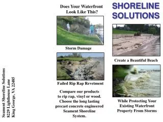
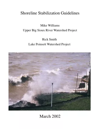
11-7 Impact of People on the Coastline Coastlines are desirable areas for human habitation, but human activity conflicts with the dynamic state of coastal systems. • Humans try to stabilize the coastline in two ways: by interfering with longshore sand transport, and by redirecting wave energy to prevent erosion. • Preventing of sand drift involves jetties and groins. • Redirecting wave energy involves breakwaters and seawalls. • Beach nourishment with sand is expensive and temporary. • An increase in sea level from global warming will cause more land to be flooded and threaten more coastal buildings.
11-5 Cliffed Coasts A sea cliff is an abrupt rise of the land from sea level. • A sea cliff is most vulnerable to erosion at its base because waves that slam against the cliff compress air inside cracks which expands violently, sediment is hurled against the cliff by the waves, and sea water dissolve some rock types. • When sufficient rock at the base of the cliff has been removed, the upper part of the cliff collapses. • Collapsed material protects the base of the sea cliff from additional erosion until it is destroyed and removed.
11-5 Cliffed Coasts • Rate at which the cliff recedes is dependent upon: • Composition and durability of cliff material. • Joints, fractures, faults and other weaknesses in the cliff material. • Amount of precipitation. • Steepness of the cliff. • The wave-cut platform is the gentle sloping area in front of the sea cliff that was produced by sea-cliff retreat.
1910 1890 1920 1990 1970
11-6 Deltas A delta is an emergent accumulation of sediment deposited at the mouth of a river as it flows into a standing body of water. • Deltas were named after the Greek letter delta. • The three major areas of a delta are delta plain ,delta front and prodelta. • In cross section, a delta’s deposits can be divided into three sets of beds: topset beds, foreset beds, and bottomset beds. • As sediment accumulates the delta expands seaward with foreset beds burying bottomset beds and topset beds covering foreset beds. • Shape of the delta can be altered by tides, waves and river deposition. • Reduction in the supply of sediment to a delta results in delta erosion and subsidence as the sediments of the delta compact.
Floods of 1849 and 1850, which caused widespread damage in the Mississippi River Valley, revealed the national interest in controlling the mighty river. Major floods again occurred in 1912, 1913, and 1927. The flood of 1927 was the most disastrous in the history of the Lower Mississippi Valley. An area of about 26,000 square miles was inundated. Levees were breached, and cities, towns, and farms were laid waste. Crops were destroyed, and industries and transportation paralyzed.
The Flood of '27 • The nation's most destructive flood began with the heavy rains that pounded the central basin of the Mississippi in the summer of 1926. By September, swollen tributaries were pouring through Kansas and Iowa. On New Year's Day, 1927, the Cumberland River threatened Nashville, topping levees at 56.2 feet. By May, the Mississippi below Memphis was a watery oval as wide as 60 miles across. Twenty-seven thousand square miles were inundated to depths up to 30 feet.
Nobody knows exactly how many died in the great disaster. Historians once estimated the death toll at 250 victims, but deaths due to disease and exposure after the immediate flood are hard to tally. John Barry's Rising Tide (1997) estimates that up to 1,000 people, mostly black, died in the Yazoo basin alone. At Mounds Landing near Greenville, for example, a flood surge blew out a dike where thousands of terrified workers were building a bunker of sandbags. Swirling west, the flood ravaged 2.7 acres of farmland before rejoining the mainstem of the Mississippi en route to Natchez and New Orleans.
The Flood Control Act of 1928 authorized work that would give the various basins protection against Mississippi River floods only, although the tributary streams within the basins caused frequent flood damage that could not be prevented by the main stem Mississippi River protective works. Later amendments to this act have authorized work that provides alleviation of the tributary flood problems.
One of the most important modifications to the project was made in 1954 when Congress authorized the feature for the control of flow at Old River to prevent the capture of the Mississippi by the Atchafalaya River.
The problem is that the Mississippi is on the verge of switching to a new channel along what is now the Atchafalaya River. The Atchafalaya River has already captured the Red River which flows from the west and used to be a tributary of the Mississippi. Already 30 percent of the flow of the Mississippi goes into a channel called the Old River and thence into the Atchafalaya River. The configuration is roughly in the form of an H in which the the Atchafalaya-Red Rivers form the left leg and the Mississippi the other with the Old River being the cross branch. • The Old River Control Project of the Corp of Engineers is working to prevent the capture of 100 percent of the Mississippi by the Atchafalaya. But the Corps of Engineers doesn't want to cut off all flow through the Old River because agricultural and marine development along the Atchafalaya River would be hurt. The Corps is committed to maintaining the 30 percent diversion that now exists.
The U. S. Army Corps of Engineers estimates that the present rate of coastal land loss is 25 square miles a year. The U. S. Fish and Wildlife Service places that figure even higher at about 34 square miles a year. The latter number is based on measuring the loss in coastal land are between 1978 and 1990. Many areas of the Gulf of Mexico coastline are retreating. If allowed to continue, this retreat can cause irreversible damage to the coastal environment, economy, and quality of life. All Gulf states have serious coastal erosion problems. Parts of Louisiana retreat 65 feet or more per year, while erosion rates of 15 feet year can be found in many other areas of the Gulf.
Wetland Loss in Louisiana (1) Sediment Deficit(2) Canals(3) Reclamation (4) Wave Erosion (5) Subsidence (6) Sea Level Rise (7) Saltwater Intrusion Nutria?????
Measures for Curtailing Wetland Loss in Louisiana Barrier Island RestorationWetland RestorationMarsh ManagementCanals and Land UseDiversion
On March 26 the Davis Pond Freshwater Diversion Project opened. Davis Pond is the largest freshwater diversion project in the world. • Capable of diverting up to 10,650 cubic feet of water per second, officials from the Army Corps of Engineers hope that the $120 million project will help revive ailing wetlands in the Barataria-Terrebonne Estuary region. The plan is to divert freshwater from the Mississippi River into the estuary, pushing back salt water encroaching from the Gulf of Mexico. • The plan met with some opposition, mostly from oyster farmers who were working in the wetlands. With the water restored to a freshwater state, the oysters could not survive. A relocation program was established for the farmers.
The key feature of the project, built into the Mississippi River Levee, is a reinforced concrete diversion structure with four 14-by-14-foot gates. It flows into a ponding area covering 10,084 acres and is expected to help preserve 33,000 acres of marsh and 777,000 acres of marshes and bays in the Barataria-Terrebonne Estuary region. A smaller, similar project in St. Bernard parish has already helped restore nearly 70 percent of the freshwater vegetation in the area.
The Caernarvon Project diverts fresh water and its accompanying nutrients and sediments from the Mississippi River to coastal bays and marshes in Breton Sound for fish and wildlife enhancement. Benefits include restoration of former ecological conditions by controlling salinity and supplementing nutrients and sediments. The bays are important to oyster production and as breeding areas for shrimp and food fishes, while the marsh areas produce food for fur-bearing animals, alligators, and migratory waterfowl. A total of 16,000 acres of marshland will be preserved and 77,000 acres of marshes and bays will be benefited by the project.