Download
1 / 20
200 likes | 337 Views
Surface Water Ch. 9. Water Cycle. The interchange of water among land, oceans, and the atmosphere. No beginning or end Can change state from liquid, ice, and vapor. http://www.metoffice.gov.uk/education/images/water_cycle.jpg. Runoff.

E N D
Water Cycle The interchange of water among land, oceans, and the atmosphere • No beginning or end • Can change state from liquid, ice, and vapor http://www.metoffice.gov.uk/education/images/water_cycle.jpg
Runoff • Describes the flow of water from rain, snowmelt, and other sources over land • Major component of the water cycle http://www.waterencyclopedia.com/images/wsci_04_img0490.jpg http://ga.water.usgs.gov/edu/watercyclerunoff.html
Water Infiltration • Water that falls as rain or snow infiltrates into the subsurface rock and soil • Precipitation infiltrates into subsurface soil an unsaturated and saturated zone
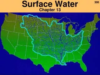
Stream System System of streams that contain a drainage basin and watershed Mississippi River drainage basin drains 41% of continental United States
Watersheds and Divides Watershed- land area drained by a stream system Divide- elevated land that divides watershed from other watershed http://servercc.oakton.edu/~billtong/eas100/watershed.gifgb
Stream Load Suspension- State in which small particles are held up and carried along by the stream’s moving water Bed Load- Sediments that are too heavy to be kept in solution or suspension and are pushed or rolled along the bottom of a stream bed http://www.indiana.edu/~g103/G103/week6/load.jpg
Stream Carrying Capacity • Ability of a stream to transport material • Depends on velocity and amount of water moving in the stream • Speed and direction are affected by the slope, depth, and width
Floodplain • Broad, flat area that extends out from a stream’s band and is covered by excess water during times of flooding • Lots of sediment is eroded from Earth’s surface • Sediment is deposited onto floodplain
Flood • Occurs when water spills over the sides of a stream’s bank onto the adjacent land • Stream has to reach flood stage; stream overflows its banks and the crest of the stream is at its maximum height http://pasc.met.psu.edu/PA_Climatologist/extreme/Floods/flood%20house%20pic.jpg
Meander - Curve or bend in a stream formed when a stream’s slope decreases, water builds up in the stream’s channels, and moving water erodes away the sides of a stream bed http://cgz.e2bn.net/e2bn/leas/c99/schools/cgz/accounts/staff/rchambers/GeoBytes%20GCSE%20Blog%20Resources/Images/Rivers/Meander.processes.jpg http://www.uwsp.edu/geo/courses/geog391/toriv/images%5Cmeander.gif
Point Bar and Cut Bank • Depositional feature of streams • Crescent shaped and located on the inside of stream beds • Gentle slopes and elevation close to the water • Often overtaken by floods • Found along meandering streams • Located on the outside of stream bends • Area of erosion • Cut nearly vertical • Area of the stream where water flows fastest
http://www.hgs.org/hgsvft/vfth1/h1bbf02b.jpg http://w3.salemstate.edu/~lhanson/gls210/Image_streams/streamMeandering.jpg http://www.uwsp.edu/geo/faculty/ritter/images/lithosphere/fluvial/cutbank_small.gif
Oxbow and Oxbow lake http://www.emporia.edu/earthsci/student/laird2/oxbow1.jpg
Deltas • Landform where mouth of river flows into an ocean, sea, desert, lake, or other river • Triangular deposit forms when stream enters a large body of water • Deposits consist of sit and clay particles • Sediments build up and slow the stream water, blocking movement Nile River Delta http://www.mbarron.net/Nile/sat-delta.jpg Mississippi River Delta formed millions of years ago. http://msnbcmedia1.msn.com/j/msnbc/Components/Photos/070717/070717_mississippi_hmed_7a.h2.jpg
Eutrophication • Process by which lakes become rich in nutrients from the surrounding watershed, thereby resulting in a change in the kinds of organisms in the lake • Natural process that can be sped up by the addition of nutrients: fertilizers containing nitrogen and phosphorus • Overpopulation of algae and other organisms lead to depletion of the water’s oxygen supply Pond undergoing eutrophication http://www.samford.edu/schools/artsci/biology/wetlands/assets/eutrophication.gif
Marshes • - Form along the mouths of streams in areas with extensive deltas • Constant supply of water leads to growth of marsh grasses- Shallow roots anchor deposits of silt and mud on the delta, slowing water and expanding the marsh area Grass, reeds, sedges, rushes, and abundant wildlife are common in marsh areas http://www.ansp.org/research/pcer/projects/marsh_climate/images/FW_tidal_marsh_1_532.jpg http://www.surreywildlifetrust.co.uk/PublishHTML/ImageLibrary/2003/November/Papercourt%20Marshes%20Robert%20Brewer350.JPG
Swamps • Low- lying areas located near streams • May develop from marshes that have filled in sufficiently to support growth of shrubs and trees • Large plants grow and shade marsh plants, killing marsh plants http://www.dkimages.com/discover/previews/960/90048234.JPG http://www.rajeshkrishnamurthy.com/plog/archives/pics/general/BullRunSwamps.jpg
Lake Formation & Evolution • Oxbow lakes form when streams cut off meanders and leave isolated channels of water • Lakes can form when stream flow becomes blocked by sediment from landslides • Other lakes have glacial origins (moraine-dammed lakes) • Limestone is the dominant bedrock where many lakes are found http://www.dorlingkindersley-uk.co.uk/static/clipart/uk/dk/sci_earth/image_sci_earth052.jpg http://volcanoes.usgs.gov/Imgs/Jpg/VEffects/PinaLakeBrk1.jpg http://maps.grida.no/library/files/formation-of-lakes-and-glacier-lake-outburst-floods-glofs-by-medvezhi-glacier-pamirs.jpg