Download
1 / 34
340 likes | 476 Views
Development of Geoprocessing Service with Realtime Data Using WPS and SOS Open Standard. Sarawut Ninsawat, Venkatesh Raghavan Graduate School for Creative Cities Osaka City University. Introduction.

E N D
Development of Geoprocessing Service with Realtime Data Using WPS and SOS Open Standard Sarawut Ninsawat, Venkatesh Raghavan Graduate School for Creative Cities Osaka City University FOSS4G2007 24-27 September 2007
Introduction • Rapid urbanization is global phenomenon and it is estimated that 60% of the worlds population will be urban by the year 2050. • Providing a clean, safe and creative urban environment has become a top priority for many nations. • Clean and safe water is one of the precious resource for the urban population . • A comprehensive system that could monitor a water quality and provide information for to stake-holders needs to be implemented • Such a system should; • Provide access to geospatial water quality data over the Web for collaborating all the departments. • Allow spatial analysis and environmental modeling functionality for decision making. • Afford timely reporting of events through real-time in situ measurement (not a archive system). FOSS4G2007 24-27 September 2007
Dynamic Web-GIS • Many standards for a Spatial Data Infrastructure (SDI), which aims to facilitate and standardize the storage and access of to spatial data • Availability of spatial analysis capability in Web-GIS applications would allow extraction of knowledge from spatial data repositories. • GRASSLinks (Huse, 1995) is one of the early implementation of analytical Web GIS for providing public access to environmental information. • Similarly, pgRouting provides some core tools for Location Based Services. • However, only the visualization and searching is inadequate for monitoring purposes. FOSS4G2007 24-27 September 2007
Web Processing Service • Recently, Open Geospatial Consortium (OGC) launches a draft specification of Web Processing Service (WPS) , originally named Geoprocessing Service. • The specified Web Processing Service provides client access to pre-programmed calculations and/or computation models that operate on spatially referenced data. • The result of request process are available to download for further analysis at user’s machine. FOSS4G2007 24-27 September 2007
PyWPS (Python Web Processing Service) • PyWPS is written in Python programming language. • GRASS Go Web • PyWPS implement OGC’s Web Processing Service standard • Operable with any other tool or just with Python itself even without GRASS GIS in the background • Current version is 2.0.0 • http://pywps.wald.intevation.org/index.psp. FOSS4G2007 24-27 September 2007
WPS Interface • GetCapabilities –This operation allows a client to describe the abilities of specific server implementation. • DescribeProcess –This operation allows a client to request detailed information about one or more process that can be executed, including the necessary input parameters and formats, and the outputs. • Execute –This operation allows a client to run a specified process implemented by the WPS, using provided input parameter values and returning the output produced. FOSS4G2007 24-27 September 2007
WPS : GetCapabilities Interface • ppt\getcap01.jpg http://mizu.info.gscc.osaka-cu.ac.jp/cgi-bin/wps.py?service=wps&version=0.4.0&request=getcapabilities FOSS4G2007 24-27 September 2007
WPS : DescribeProcess Interface http://mizu.info.gscc.osaka-cu.ac.jp/cgi-bin/wps.py?service=wps&version=0.4.0&request=describeprocess&Identifier=shortestpath FOSS4G2007 24-27 September 2007
WPS : Execute Interface[ProcessAccepted] http://mizu.info.gscc.osaka-cu.ac.jp/cgi-bin/wps.py?service=wps& version=0.4.0&request=execute& Identifier=shortestpath&Datainputs=cost,0,x1,596527,y1,4921298,x2,598173,y2,4923383&store=true&status=true FOSS4G2007 24-27 September 2007
WPS : Execute Interface[ProcessStarted] http://mizu.info.gscc.osaka-cu.ac.jp/wpsoutputs/executereponse-2007-6-18-15-9-3.xml FOSS4G2007 24-27 September 2007
WPS : Execute Interface[ProcessSucceeded] http://mizu.info.gscc.osaka-cu.ac.jp/wpsoutputs/executereponse-2007-6-18-15-9-3.xml FOSS4G2007 24-27 September 2007
Web Processing Service Server PyWPS System GRASS GIS GML Execute Request **Execute Request http://wps.org/cgibin/wps.py?service=wps& version=0.4.0&request=execute& Identifier=shortestpath&Datainputs=cost,0,x1,596527,y1,4921298,x2,598173,y2,4923383&store=true&status=true GeoTiff GML or GeoTiff Result User Shp Web-Mapping Application PostgreSQL/PostGIS FOSS4G2007 24-27 September 2007 WFS WCS GeoTiff, GML
WPS : Result[GML] FOSS4G2007 24-27 September 2007
Demo site FOSS4G2007 24-27 September 2007
Real-Time Data Web Processing Service Server PyWPS System GRASS GIS GML Execute Request GML or GeoTiff Result GeoTiff User Web-Mapping Application Shp PostgreSQL/PostGIS WFS WCS GeoTiff, GML FOSS4G2007 24-27 September 2007
Sensor Network • In the past, to acquire an information from remote place consume time and money. • Environmental monitoring requires real-time reporting and archiving of events and phenomenon. • Sensors and communications chips can be embedded in data logging devices enabling them to. • communicate with other devices, serviced and upgraded remotely through computer network. • collect huge amount of information at low costs via a network of field sensors. FOSS4G2007 24-27 September 2007
Wireless Sensor system • The sensor-node “Field Server” equipped with a Web server and Wireless Lan was introduced for a remote field monitoring system • Manage and periodically collect monitoring data via the Internet connection from remote place. • More than 40 Field Servers are currently deployed in various parts of Japan, the United States, Thailand, China, Korean and Taiwan. • However, the lack of integration and communication between these sensor networks, often leaves such valuable information underutilized. FOSS4G2007 24-27 September 2007
Sensor Web Enablement (SWE) FOSS4G2007 24-27 September 2007
Sensor Web Enablement (SWE) • O&M [Observations & Measurements Schema] • SensorML [Sensor Model Language ] • TML [Transducer Markup Language] • SOS [Sensor Observation Service] • In this study, 52N Sensor Observation Service (52NSOS) has been used. • Provides the framework of the sensing resources to service users. • SPA [Sensor Planning Service] • SAS [Sensor Alert Service] • WNS [Web Notification Service] FOSS4G2007 24-27 September 2007
Sensor Observation Service (SOS) GetObservation Observations/Measurements FOSS4G2007 24-27 September 2007
SOS Result FOSS4G2007 24-27 September 2007
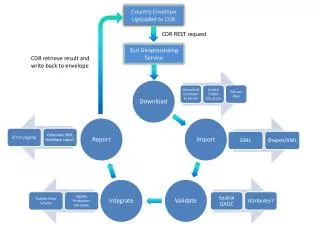
Implementation of Real-time unmanned modeling map Sensor Observation Service (SOS) WFS WCS Web Processing Service (WPS) GeoTiff, GML • Real-time map • Update in situ data to modeling computation • Water Quality demonstrate is developing. • In this demonstrate, simulated sensor nodes are used to supply a water quality value to SOS. Web-Mapping Application User FOSS4G2007 24-27 September 2007
WPS and SOS integration • Due to the capability of WPS that allows to access distributed geospatial data across the network (such as WCS and WFS). • It is possible to utilize the observation from SOS server. • Presently, WPS are not able to directly use this observation data in further processing. • The observation is converted to a feature object as GML document, which is an acceptable data format for WPS. FOSS4G2007 24-27 September 2007
SOS Result -> GML FOSS4G2007 24-27 September 2007
Water Quality Index (WQI) • The WQI, which was developed in the early 1970s, • Over 100 water quality experts were called upon to create a standard Water Quality Index. • Monitor water quality changes in a particular water supply over time, • Compare a water supply's quality with other water supplies in the region or from around the world. • The results can also be used to determine if a particular stretch of water is considered to be "healthy." FOSS4G2007 24-27 September 2007
Seven water quality parameters • Dissolved Oxygen (% Saturation) • Nitrate (mg/L) • pH • Total Phosphate (mg/L) • Total Dissolved Solids (mg/L) • Temperature Change (C) • Turbidity (NTU) FOSS4G2007 24-27 September 2007
WQI Calculation qn that is a quality rating is computed using the following equation. Where Vactual : actual amount of n parameter from analysis Videal : ideal value of water quality parameter Videal for pH = 7, D.O. = 14.6 mg/L and for other parameters is zero. Vstandard: recommended WHO standard value of water quality parameter. FOSS4G2007 24-27 September 2007
WQI Calculation Where W (Weight factor) is computed using the following equation. Where K is proportionality constant that is derived from Where Sn and Si are the WHO standard values of each water quality parameters. FOSS4G2007 24-27 September 2007
WQI • The Q-value for each test should then be multiplied by the weighting factor. • Summarize of all Q-value is a Water Quality Index rating. • You may perform as many of the following tests as you wish. • However, at least 6 must be completed, Divide the total of the Q-value by the total of the Weighting Factor to obtain the Water Quality Index rating. FOSS4G2007 24-27 September 2007
Demo System : WQI(Biwa Lake Supplies water to Osaka) FOSS4G2007 24-27 September 2007 • http://mizu.info.gscc.osaka-cu.ac.jp/waterwqi/
Demo system : SST (WCS data source) FOSS4G2007 24-27 September 2007 • http://mizu.info.gscc.osaka-cu.ac.jp/waterwqi/
Demo site : Turbidity Index (WCS data source) FOSS4G2007 24-27 September 2007
Conclusion • The integration of two OGC-compliant open standards to create a comprehensive geoprocessing service utilizing real-time data from sensor observation network has been described • SOS can be a valuable data source for WPS via the integrated client developed as a part of this study • Due to standardization, the usage of geodata as well access to real-time data much easier and less expensive allows better decision making. • We are now working on development of field water quality sensor that could be integrated with the present system for monitoring groundwater quality urban areas. FOSS4G2007 24-27 September 2007
Thank you FOSS4G2007 24-27 September 2007