Download
1 / 29
310 likes | 585 Views
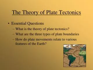
Introducing the Theory of Plate Tectonics. Prepared by: Mrs. C. Hildreth March 5, 2004 Shenendehowa High School Clifton Park, NY Diagrams and information from: Tarbuck, E. & Lutgens, F. Earth Science . Prentice-Hall, Inc. 2000 Earth Science . McDougal Littell Inc. 2003

E N D
Introducing theTheory of Plate Tectonics • Prepared by: • Mrs. C. Hildreth March 5, 2004 • Shenendehowa High School • Clifton Park, NY • Diagrams and information from: • Tarbuck, E. & Lutgens, F. Earth Science. Prentice-Hall, Inc. 2000 • Earth Science. McDougal Littell Inc. 2003 • Spaulding, N & Namowitz, S. Heath Earth Science. DC Heath & Co. 1994. NEXT
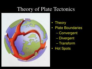
New York State Physical Setting / Earth Science Core Curriculum • Standard 2, Key Idea 1--Information technology is used to retrieve, process, and communicate information as a tool to enhance learning. • Standard 4, Key Idea 2 -- Many of the phenomenon that we observe on Earth involve interactions among components of air, water, and land. • Earth’s internal heat engine is powered by heat from the decay of radioactive materials and residual heat from Earth’s formation. Differences in density resulting from heat flow within Earth’s interior caused the changes explained by the theory of plate tectonics: movement of the lithospheric plates; earthquakes; volcanoes; and the deformation and metamorphism of rocks during the formation of young mountains. • Major Understandings: 2.1 a, b, k, l, m, n • The outward transfer of Earth’s internal heat drives convective circulation in the mantle that moves the lithospheric plates comprising Earth’s surface. • The lithosphere consists of separate plates that ride on the more fluid asthenosphere and move slowly in relationship to one another, creating convergent, divergent, and transform plate boundaries. • Many processes of the rock cycle are consequences of plate dynamics. • Many of Earth’s surface features are a consequence of forces associated with plate motion and interaction. • Standard 6, Key Idea 1, 2, 5 -- Process skills: systems thinking; models; patterns of change. NEXT
EARTH’S INTERNAL HEAT ENGINE AND CONVECTIONThe diagram below shows a cross section of Earth to a depth of approximately 700 km (not to scale). Arrows show motion of Earth’s interior and surface. In this lesson you will learn about the dynamics of heat generated motion.You will also explore evidence of the Theory of Plate Tectonics.TO VIEW THE LESSON: Click on each number in order from # 1 to #6.Answer the questions on the accompanying notesheet. 6. Convergence 4. Divergence 5. Convergence 2. Asthenosphere 3. Convection 1. Earth’s Interior
CROSS-SECTION VIEW OF EARTH’S INTERNAL STRUCTURE Since its formation, Earth has been losing heat (cooling) through two processes: 1. Decay of radioactive materials 2. Residual heat from Earth’s formation See your Earth Science Reference Tables, page 10. Find the following: Inner core Outer core Stiffer mantle Asthenosphere Observe the temperature ranges within each of these interior layers. BACK
ASTHENOSPHERE AND LITHOSPHERE The surface of Earth is broken into huge lithospheric or crustal plates. The lithosphere consists of the upper rigid mantle and the overlying oceanic or continental crust. The asthenosphere is capable of flow. This is because the temperature in the asthenosphere is slightly greater than the melting point of the ultramafic rock material which makes up the asthenosphere. This causes a partial melting of the mantle. See your Earth Science Reference Tables, page 10. Find the following: lithosphere rigid mantle oceanic crust continental crust asthenosphere. BACK
CONVECTIONHeat from Earth’s interior causes density differences and results in convection in the asthenosphere. This region of high heat flow pushes magma upward into the solid lithospheric plates (upper rigid mantle and crust), forcing the plates aside and forming new rock on the sea floor. See the Earth Science Reference Tables, page 10.Observe the convection arrows in the asthenosphere. Where the arrows are shown rising, they diverge, or split apart. Where arrows are shown sinking, they converge, or come together. BACK
DIVERGENCE Heat flow causes the lithosphere to break apart (divergence) and form a rift valley. These rift valleys form the boundaries between plates and new rock is formed as the magma cools. This is referred to as sea-floor spreading.Older rock is pushed aside where new rock is forming. As distance from mid-ocean ridges increases, age of rock also increases. Most divergent boundaries have mid-ocean ridges with deep rift valleys along their entire length. Find the rift valley and mid-ocean ridge in the diagram below.See your Earth Science Reference Tables, page 10. Find the Mid-Atlantic Ridge.See your Earth Science Reference Tables, page 5. Again find the Mid-Atlantic Ridge. Below the page 5 map is a diagram of a divergent plate boundary. Locate other divergent plate boundaries (mid-ocean ridges) on the map. OLDER ROCK OLDER ROCK HEAT FLOW NEXT
DIVERGENCE WITH TRANSFORM FAULTSRift valleys are broken into segments by transform faults. Movements along these fractures are a source of earthquakes that occur along the ridge.Observe the many transform faults along the mid-ocean ridges on page 5 of the Earth Science Reference Tables. NEXT
TRANSFORM BOUNDARYAt the boundaries of some areas, the lithospheric plates are sliding past each other. Frequent earthquakes occur along these transform boundaries as huge masses of rock move. Find a transform boundary on the US west coast on page 5 of the Earth Science Reference Tables. NEXT
TRANSFORM BOUNDARYThe San Andreas Fault, located in western California, is the source of frequent earthquakes. Here, the Pacific Plate and the North American Plates are sliding past each other. The average rate of movement along the San Andreas Fault is about 5 cm per year. Some areas have not moved for centuries. Pressure has been building and is thought to be the most likely places for future earthquakes. Find the San Andreas Fault on page 5 of the Earth Science Reference Tables. San Andreas Fault BACK
CONVERGENCE:ocean-continental plate boundaryContinental crust is made of granite, which is less dense than ocean crust, which is made of basalt. (See Earth Science Reference Tables, pg. 6 and 10) The more dense ocean crust subducts (goes under) continental crust, forming a deep trench on the ocean floor. High temperatures and pressures in the asthenosphere cause the subducting plate to melt. Magma then rises to the surface and escapes in volcanic eruptions, forming major mountain ranges on the continent. Eruptions can be very violent and earthquakes at subduction boundaries occur much deeper in the lithosphere than at other plate boundaries. It is important to recognize that plates formed at mid-ocean ridges are destroyed at subduction zones.The Convergent Plate Boundary diagram, at the bottom of the Earth Science Reference Tables page 5, indicates which plate is subducting and which plate is overriding. BACK
CONVERGENCE:oceanic-oceanic plate boundaryWhere two ocean plates converge, the older, more dense ocean crustal plate subducts under the younger, less dense. Remember, the older crust is farther from the mid-ocean ridge where it was originally formed as new seafloor. Island arcs are formed near ocean trenches as subducting plates are melted and rise to the surface as volcanic eruptions. Island arcs are found along the Aleutian Trench and Tonga Trench in the Pacific Ocean. Find the Aleutian Trench and Tonga Trench on page 5.. NEXT
CONVERGENCE:continental-continental plate boundaryIf converging plates are both carrying continents, the continents may be welded into a single larger continent. This converging boundary is known as a collision boundary. The collision causes the lithosphere to be pushed up into a mountain range. NEXT
CONVERGENCE: India colliding with AsiaThe Himalayan Mountains are an example of a collision boundary that is still forming today. Here India is pushing northward into China at a rate of about 5 cm each year. India is now welded to the Eurasian continent with the world’s highest mountains and frequent earthquakes. The Appalachian Mountains formed by the same process during the collision of North America and northern Africa. At a much later time, these continents were rifted apart, forming the Atlantic Ocean. NEXT
CONVERGENCE:This map shows theAustralian-Indian plate colliding with the Eurasian plate. Find India and the Himalayan Mountains. HIMALAYAN MOUNTAINS INDIA NEXT
WORLD MAP – TECTONIC PLATE BOUNDARIESStudy the three types of tectonic plate boundaries shown below. Locate these boundaries on the map on pg. 5 in your Earth Science Reference Tables. NEXT
EVIDENCE: This world map shows the distribution of shallow-, intermediate-, and deep-focus earthquakes. Deeper focus earthquakes occur in subduction zones along convergent plate boundaries. Shallow focus earthquakes occur along mid-ocean ridges and transform boundaries. NEXT
EVIDENCE:EARTHQUAKE FOCI DEPTH [Japan trench region]Japan is an island arc created from the subduction of the Pacific Plate. Earthquakes in western Japan are deeper than earthquakes in eastern Japan. NEXT
EVIDENCE: Many earthquakes and volcanic eruptions surround the Pacific Ocean. This is known as the “Ring of Fire”. NEXT
EVIDENCE: Volcanic activity occurring at subduction boundaries usually results in more violent eruptions. Figure #1 Mount St. Helen’s Figure #2 Mt. Uluigalau Volcano, Fiji NEXT
EVIDENCE:map of the ocean floorRed areas indicate shallower regions along continental shelves. Blue areas show the deepest regions in the oceans. Green areas show the locations of undersea mountain ranges. NEXT
EVIDENCE:physical world map…locations of mountain rangesMountain ranges are formed at active plate boundaries where tectonic plates are converging. Find the Cascade Mts., the Andes Mts. and the Himalaya Mts. in the map below. Cascades Himalayas Andes NEXT
EVIDENCE:magnetic polarity patterns in seafloor rocksThere have been four major polarity reversals in the past four million years. Geologists use the knowledge of magnetic polarity to compare ages of rocks near spreading centers on the ocean floor. • The diagram below shows divergent plates at a mid-ocean ridge. Solid arrows show direction of normal polarity. Currently forming rocks at the spreading center show normal polarity. North Reverse Polarity Sea Level Rift Valley Mid-Ocean Ridge OLDER ROCK OLDER ROCK Spreading center 4 0 4 NEXT Millions of years
EVIDENCE : TECTONIC HOT SPOTSNot all volcanism occurs at plate boundaries. Hot spots are usually located in the middle of lithospheric plates. The hot spot seems to remain in the same location while the plate moves over it. This results in a chain of extinct volcanic islands like the Hawaiin Islands. Direction of Plate Movement North KAUAI OAHU MOLOKAI NEXT Active Volcano is over the Hot Spot MAUI HAWAII
PLATE TECTONICS AND THE ROCK CYCLENew rocks are continually being created due to tectonic forces. Igneous rocks form from the solidification of magma and volcanic lava.Metamorphic rocks are changed by the heat and pressure caused by converging of tectonic plates.Sedimentary rocks are created when other rocks are weathered and eroded, deposited as sediments, and then compacted and cemented.Find the location of each of these processes in the diagram below. Igneous Sedimentary Metamorphic NEXT
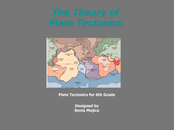
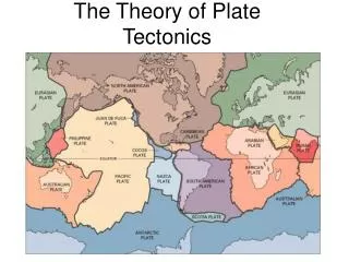
PLATE BOUNDARIES MAPThe map below shows the major plate boundaries currently identified by the Theory of Plate Tectonics. You should now be familiar with the evidence which supports this theory, as well as with the interactions and types of plate boundaries as shown on page 5 of the Earth Science Reference Tables. Pacific Plate NEXT
QUIZ YOURSELF Use your Earth Science Reference Tables, pg. 5 and 10Then click NEXT for the KEY. Correct your answers. Then you may go back and review the slide presentation if you have time. • 1. What type of plate boundary occurs at the Peru-Chile Trench? • 2. The Mid-Atlantic Ridge forms what type of plate boundary? • 3. At the Tonga Trench, lithospheric plates are [converging, diverging, sliding past]. • 4. The African Plate is moving toward which direction? • 5. Which hot spot is located on the North American Plate? • 6. Where is the Nazca Plate subducting and being destroyed? • 7. Where is the African Plate beginning to break apart? • 8. Which direction is the Pacific Plate moving relative to the North American Plate? • 9. What is the name of the fault that separates the Pacific and N. American Plates? • 10. What is happening in the asthenosphere which results in volcanism in rift valleys along the Mid-Atlantic Ridge? NEXT
KEY • 1. What type of plate boundary occurs at the Peru-Chile Trench? • 2. The Mid-Atlantic Ridge forms what type of plate boundary? • 3. At the Tonga Trench, lithospheric plates are [converging, diverging, sliding past]. • 4. The African Plate is moving toward which direction? • 5. Which hot spot is located on the North American Plate? • 6. Where is the Nazca Plate subducting and being destroyed? • 7. Where is the African Plate beginning to break apart? • 8. Which direction is the Pacific Plate moving relative to the North American Plate? • 9. What is the name of the fault that separates the Pacific and N. American Plates? • 10. What is happening in the asthenosphere which results in volcanism in rift valleys along the Mid-Atlantic Ridge? CHECK YOUR ANSWERS: • 1. CONVERGENT 6. PERU-CHILE TRENCH • 2. DIVERGENT 7. EAST AFRICAN RIFT • 3. CONVERGING 8. NORTHWEST • 4. EAST 9. SAN ANDREAS FAULT • 5. YELLOWSTONE 10. RISING HEAT FLOW or CONVECTION NEXT
RELATED WEBSITES Click on some of the following to learn more about the Theory of Plate Tectonics… • http://pubs.usgs.gov/publications/text/understanding.html • http://kids.earth.nasa.gov/archive/pangaea/ • http://geology.er.usgs.gov/eastern/tectonic.html • http://vulcan.wr.usgs.gov/Glossary/PlateTectonics/description_plate_tectonics.html • http://observe.arc.nasa.gov/nasa/earth/tectonics/Tectonics1.html • http://scign.jpl.nasa.gov/learn/plate.htm Click to Review This Lesson QUIT